 |
 |
|---|---|
| Plate I-4 | Map |
|
|
|---|---|
| Plate I-4 | Map |
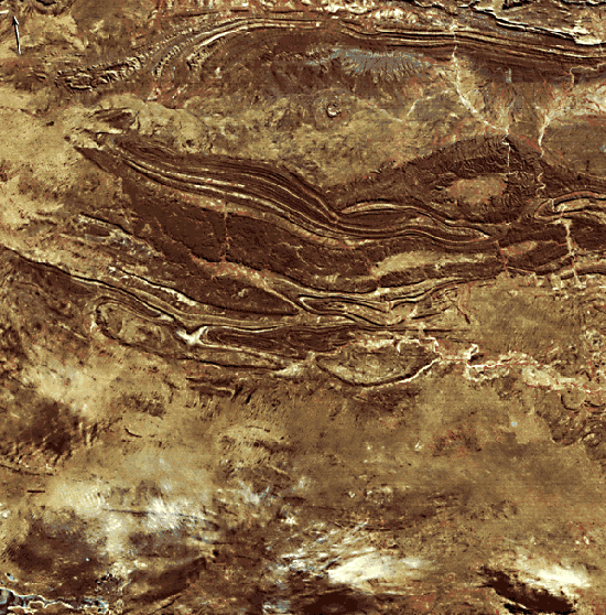
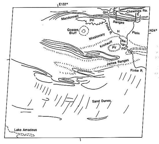
The east-west fold belt of central Australia contains some of the world´s most fascinating desert scenery. The folding occurred during Late Devonian and Carboniferous time and affected a thick sequence of Late Proterozoic through Carboniferous rocks comprising the Amadeus Basin (Wells et al., 1970). The principal mountain areas include the Macdonnell, James, and Krichauff Ranges. Relatively tight anticlines and broad synclines are clearly indicated by the differential erosion of the various sedimentary rocks.
The oldest rocks on this image occur in the northeastern corner, where the Chewings Range stands as a resistant member of the Lower Proterozoic Arunta Block. During the Upper Proterozoic, this block became the source area for sedimentation into the Amadeus Basin to the south. Oldest of the sediments deposited in this basin is the Heavitree Quartzite, which forms magnificent resistant ridges breached by spectacular gorges such as Ellery Big-Hole (E on the sketch map) and Ormiston Gorge (0). Deposition of the Heavitree Quartzite was followed by the emplacement of a thick sequence of sediments ranging from Adelaidean to Devonian in age (850 to 400 million years ago). The Macdonnell and James Ranges expose older rocks in this sequence, while the Krichauff Range and the Pertnjarra Hills (PH) expose younger Devonian/Carboniferous rocks. The latter consist mainly of sand and conglomerate shed during the Alice Springs Orogeny, which occurred about 350 million years ago. The orogeny resulted in the spectacular folds of the James Range and the lesser ranges to the south.
| Figure I-4.1 |
|---|
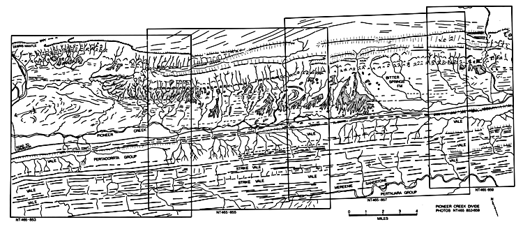 |
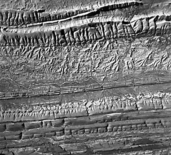
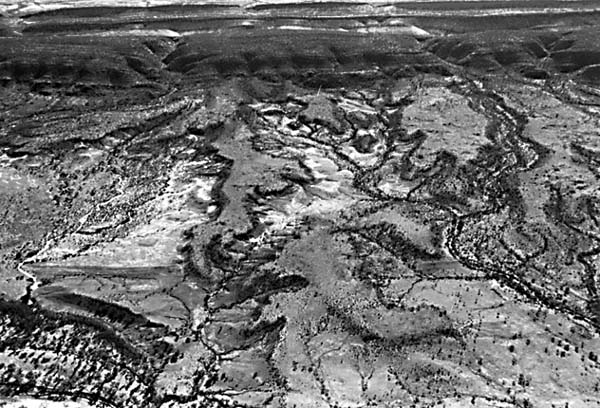
Figure I-4.1 is a detailed geomorphic map of a portion of this Landsat image that was prepared from standard low-altitude aerial photography. The location of the mapped area is shown as a box in the northwest corner of the index map. The map was prepared from photographs NT465-853, NT465-855, NT- 465-857, and NT465-859, which were flown in 1978 and produced at 1:53000 for the Australia national mapping program. Figure I-4.2 shows photograph NT465-855, which was used in this exercise. The stippled areas mapped in Figure I-4.2 are dissected remnants of debris-mantled pediment surfaces of Middle Tertiary age. These surfaces comprise remnants of a deeply weathered Tertiary landscape that existed in the valleys between the resistant ridges (Figure I-4.4).
| Figure I-4.2 |
|---|
 |
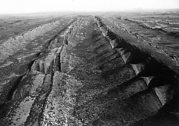
The Mesozoic and Tertiary history of this region was a prolonged episode of denudation, during which multiple erosion surfaces evolved. Fluvial action and deep weathering were both important during this period. In a sense, the structures were "etched" by the differential erosion (Figure I-4.3). Less resistant rocks were preferentially removed to comprise low plains. During the Tertiary, a wet climate promoted the development of lakes in some of the plains. Changing climate also promoted an episode in the Miocene of extensive silicification on the landscape. This produced siliceous duricrusts called silcrete. The latest Tertiary and Quaternary was marked by progressively more arid conditions. Extensive sand sheets and dunes developed during the Quaternary.
| Figure I-4.3 | Figure I-4.4 |
 |
 |
|---|
The central ranges line up with a pattern of high-amplitude highs and lows in the free-air and Bouguer gravity anomaly pattern over Australia. Gravity highs occur over the thrust-bounded cratonic blocks, such as the Arunta Block, and lows occur over sedimentary basins, such as the Amadeus Basin. The pattern is thought to be consistent with north-south lateral compression. This compression could have either: (1) deformed the central Australian lithosphere into a series of buckle-like undulations, or (2) broke the lithosphere into juxtapositioned blocks through mechanical failure. The Devonian/Carboniferous Alice Springs Orogeny was presumably the major manifestation of the compression. The gravity anomalies show that the cratonic blocks are uncompensated today, suggesting that lateral compression may still be maintaining the Amadeus Basin. The combining of geophysical data sets with orbital imagery thus provides an important perspective on regional tectonic geomorphology.
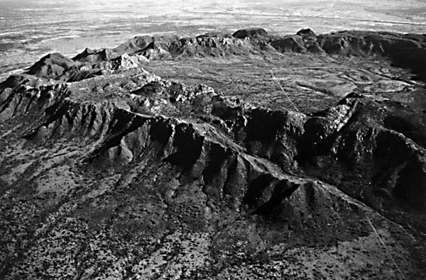
Perhaps the most striking structure in this region is the Gosses Bluff astrobleme. This impact structure formed during the Early Cretaceous, about 130 million years ago (Milton et al., 1972). Deep erosion has exposed a deformed zone 20 km in diameter (dashed pattern on the index map). The central uplift (Figure I-4.5) is a ring of vertically dipping sandstone units. Less resistant sandstone and siltstone comprise the central depression, and brecciated sediments form the outer zone on the Missionary Plain. Thus, erosion has preferentially removed the breccia, but little of the coherent bedrock. Gosses Bluff is an excellent example of a partially eroded impact structure.
| Figure I-4.5 | Figure I-4.6 |
 |
 |
|---|
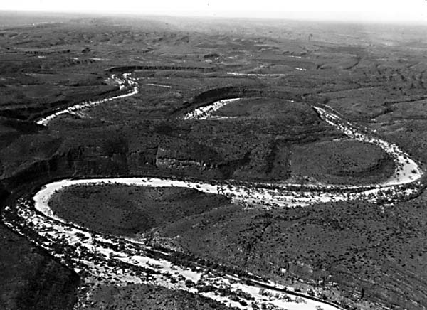
The prominent meandering valley of the Finke River cuts directly across the mountain trends. The Finke River Gorge (Figure I-4.6) is an example of this cross- axial or discordant drainage. Other gorges and water gaps are well displayed in the Macdonnell Range. The discordance of drainage with regional drainage has been attributed by various investigators to superimposition, antecedence, and inheritance from the ancient erosion surface. Speculation that the Finke was antecedent to the Devonian/Carboniferous folding has led to its popular description as the "world´s oldest river." However, there is no evidence to associate the river with its present course any time earlier than the Cretaceous. Current hypotheses suggest that the drainage of central Australia developed since the Cretaceous through a complex combination of inheritance, local superimposition, and stream capture (Mabbutt, 1966). Landsat 1373-00364, July 31, 1973.
Continue to References| Chapter 1 Table of Contents.| Return to Home Page| Complete Table of Contents