 |
|---|
| Plate P-12 |
|
|---|
| Plate P-12 |
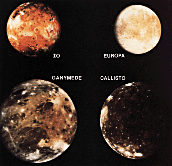
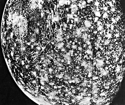
The four largest satellites of Jupiter, although visible from Earth with 7-power binoculars, were not seen close-up until 1979 when Voyagers 1 and 2 flew through the Jovian system. The variety and strangeness of landforms on these and the Saturnian satellites could hardly have been greater if the spacecraft had made interstellar flights and returned photographs of another solar system. The three icy Galilean satellites, shown in a composite view are discussed here; Io will be treated separately (Plate P-13).
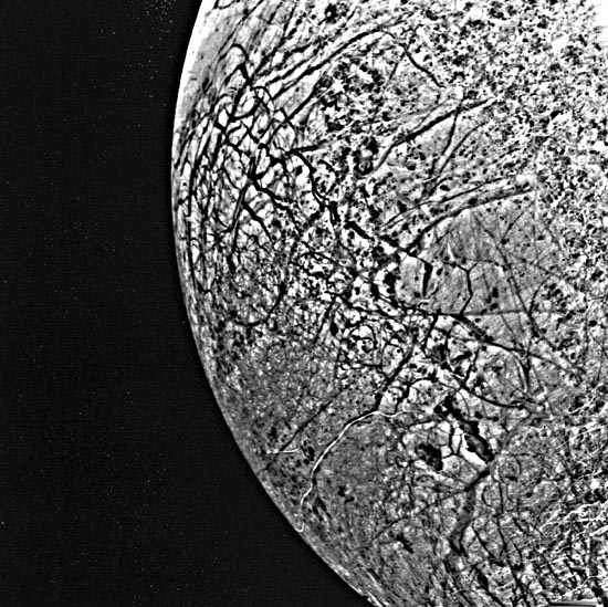
The innermost of these three bodies, Europa, possesses a network of lines that are strikingly similar to prespacecraft renderings of Percival Lowell´s fancied canals on Mars, at least in early distant views. At higher resolution, the terrain is revealed as criss-crossed with a complex network of intersecting lineaments cutting an otherwise smooth surface, with only a few craters. The lineaments, many of them hundreds of kilometers long, have little evident relief and are visible mainly because of albedo or color contrast. They have been intensively studied by many investigators; the following account is based primarily on the comprehensive treatment by B. K. Lucchitta (1981) and her colleagues.
| Figure P-12.1 | Figure P-12.2 |
|---|---|
 |
 |
As shown in a closer view (Figure P-12.1), the most conspicuous lineaments are dark bands, generally with sharp edges and often wedge-shaped. They dominate the upper left part of the area shown here. Because they cut most other features, they are probably the youngest class of lineament and they appear to have been formed by local expansion and rotation of the crust, which is presumed to be impure water ice from reflection spectra. The wedge-shaped bands are concentrated near the point farthest from Jupiter, suggesting that they are in some way related to tidal deformation. In the lower right part of the image, parts of three gray bands are visible; when seen in broader perspective, they form concentric arcs around a common point in the southern hemisphere. They show some similarities to the dark wedge-shaped bands, but appear to be considerably older. They may represent parts of large circles, but there are so many ways that such features could originate (such as major impacts) that further speculation at this time seems fruitless. A third type of lineament, also curved, dominates the right side of the area shown here. These are ridges with at most a few hundred meters relief, best seen along the terminator. They sometimes form cycloidal patterns, but may locally grade into straight segments. Their azimuthal distribution, peaking in the northwest and northeast, suggests the regmatic shear pattern often postulated for the Earth, and Lucchitta et al. (1981) suggest they may have been formed as conjugate shears. The specific nature of the curved ridges is unclear; two possibilities are ice dikes and compressional structures (reverse faults or folds). A major problem in interpreting the Europan lineaments is uncertainty about the internal structure of the satellite. Its density implies a silicate interior, but it may have retained a liquid interior long after the outer ice crust formed. Tidal interactions, supplemented by internal radioactivity, have evidently led to resurfacing and renewed tectonism, as shown by the near absence of impact craters. It is obvious that study of Europan tectonics will be a fruitful one for many years, especially when better imagery is obtained from the Galileo mission in the late 1980s.
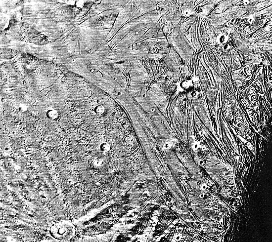
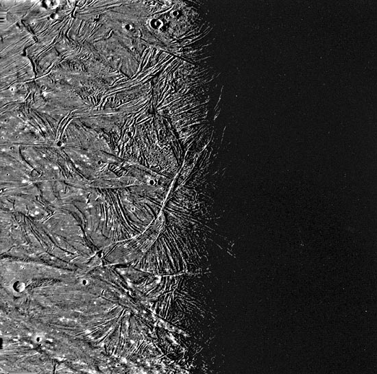
Ganymede Figures P-12.2 and P-12.3) has a bulk density of 1.9 gm/cm3, implying a substantial ice fraction. The expectation that closeup views from Voyager would show some type of ice landscape proved correct. The surface is an intricate montage of dark cratered terrain (left part of Figure P-12.2), cut by a network of light-toned grooved terrain (right part of Figure P-12.2; left part of Figure P-12.3). The grooved terrain is clearly younger than the cratered terrain, as shown not only by its cross-cutting relationships but by its much lower crater density. The absolute ages of both have been estimated by Shoemaker and Wolfe (1980) to be older than 3 billion years (i.e., in the same general range as the lunar surface).
| Figure P-12.3 | Figure P-12.4 |
|---|---|
 |
 |
The impact craters, although modified by plastic flow in the ice, are clearly recognizable cousins to the classic example, Tycho (Plate P-l). The grooved areas, or sulci (sing. sulcus), are unlike anything seen before the Voyager missions. They superficially resemble folded mountains such as the Appalachians or, more plausibly, the Zagros Mountains. However, the consensus of almost all investigators is that they are extensional structures of some type, probably families of normal faults that have formed repeatedly, producing the intricate superposition relationships noted in Figure P-12.3. Flow of water from the interior of Ganymede may have accompanied the faulting. It is tempting to draw a comparison between the grooved terrain and terrestrial spreading centers, Ganymede providing a type of ice/water analog to the basalt eruptions found on Earth. A more plausible analog may be the grooved terrain on Saturn´s Enceladus (Figure P-14.3). This account has only touched on the fascinating variety of strange landforms seen on Ganymede; further examples are illustrated in the initial Voyager reports (Smith et al., 1979) and the summary by Johnson (1982).
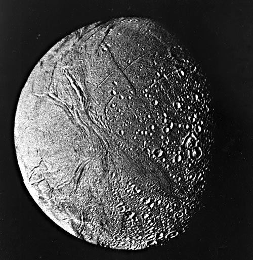
The last of the Galilean satellites covered here is Callisto (Figure P-12.4), which is also the most primitive one. Callisto´s density is close to that of Ganymede, suggesting that it too consists of a thick crust and mantle of ice over a silicate core. The landforms seen on Callisto favor such a structure; the terrain can be summarized as an extremely old one, saturated with craters formed in an icy crust (Smith et al., 1979). The closeup view shows general characteristics of this terrain, as well as the gigantic Valhalla ring structure. Valhalla superficially resembles the Orientale Basin on the Moon or the Caloris Basin on Mercury, and in fact, it is judged to be a large impact structure. However, it is morphologically very different, displaying little relief and no evidence of a distinct ejecta blanket. It is generally believed that the initial crater has nearly been erased by plastic flow of the ice, as has apparently happened to many smaller craters both on Callisto and Ganymede. 83-H-205.
Continue to Plate P-13| Chapter 10 Table of Contents.| Return to Home Page| Complete Table of Contents|