 |
 |
|---|---|
| Plate P-7 | Map |
|
|
|---|---|
| Plate P-7 | Map |
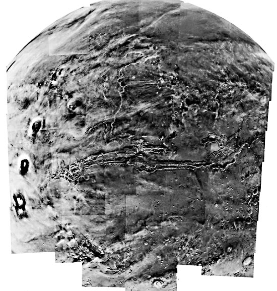
One of the most striking discoveries made by the Mariner 9 mission was the immense series of equatorial canyons, collectively named the Valles Marineris, shown in the Plate as a mosaic of Viking Orbiter images and in a USGS shaded relief map derived from the imagery (Figure P- 7.1). The Valles Marineris would reach from almost coast to coast if it were in the United States; again, the most immediately obvious characteristic of Martian physiographic features is their great size. However, a number of terrestrial features are of comparable size and geometry; the East African rift valleys come to mind at once, and of course, the global system of terrestrial oceanic ridges are in aggregate much longer.
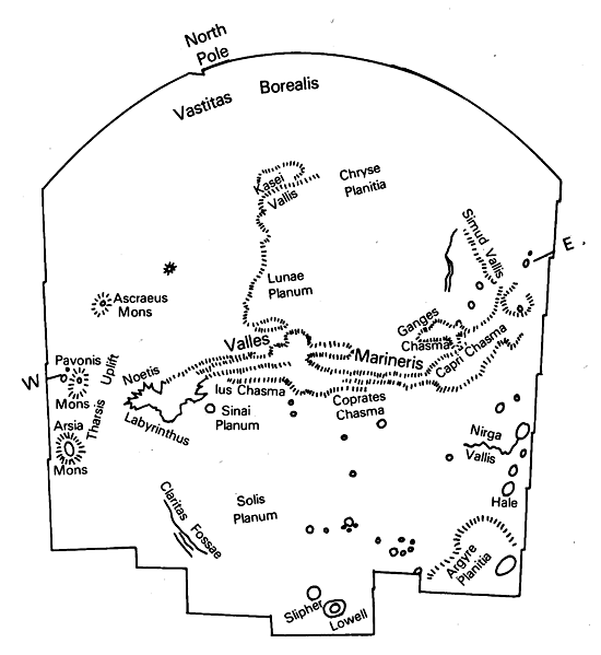
Before the details of the Valles Marineris are discussed, their regional relationships should be pointed out. The Valles are radial to the Tharsis uplift, which lies to the west, and slope off into low areas to the east (Figure P-7.1). There is a corresponding geomorphic gradation from dominantly tectonic valleys to those formed by fluvial processes. It will be helpful here, following Carr (1982), to distinguish between Martian "canyons" and "channels." "Canyon," as the term is applied to Mars, refers to features that do not form integrated drainage networks, consisting instead of segmented and frequently closed depressions showing little evidence of water erosion or deposition. They are inferred to be caused primarily by tectonism or subsidence. "Channel," in contrast, implies the opposite characteristics and, in turn, an origin by fluid erosion or deposition.
| Figure P-7.1 | Figure P-7.2 |
|---|---|
 |
 |
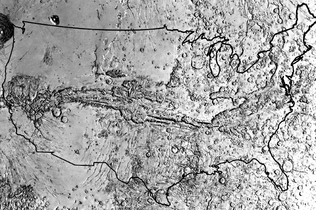
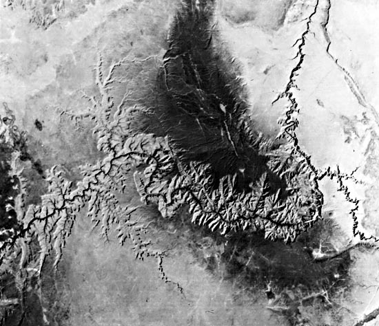
The Valles Marineris area composite feature, formed by the interaction of several different geomorphic and tectonic processes. This composite nature is well illustrated by a classic Mariner 9 view (Figure P-7.2) of what has since been named Ius Chasma (from the Latin term for large canyon or chasm). This segment of the Valles Marineris is roughly 60 km wide and 2 to 3 km deep, and can be compared with a partial Landsat frame showing the Grand Canyon and Kaibab Plateau in an area 130 km wide (Figure P-7.3). The main part of Ius Chasma is agreed to be of tectonic origin, the canyon being fundamentally a graben. There are all gradations, however, from grabens to chains of craters such as those north of Ius Chasma. These craters presumably result from collapse of the surface material into underlying fissures, although similar crater chains on the Moon are generally interpreted as volcanic, probably diatremes. The question of just how much of the main canyon's volume is the direct result of faulting remains open. Some authors have proposed a Martian version of plate movement, with the tectonic part of the Valles Marineris resulting from horizontal (north-south) spreading. However, the majority view is that the walls were never in contact and that the movement has been primarily subsidence.
The tributary canyons of Ius Chasma are strikingly similar to those of the Grand Canyon, such as the Little Colorado River at far right in the Landsat view. Despite this similarity, the origin of the Martian tributaries is by no means understood. The terrestrial ones are clearly the result of water erosion, involving spring sapping and rain runoff. However, liquid water could not exist on Mars at this time or for along time in the geologic past, leaving some sort of sapping as the most likely origin for the tributaries to Ius Chasma. Sharp and Malin (1975) have proposed such an origin, perhaps aided by dry mass wasting following the sublimation of ground ice. An interesting parallel between the Martian and terrestrial tributaries is the degree of fracture control shown by a few. The terrestrial examples are known to result from differential erosion along faults such as those extending southward along the Kaibab uplift.
| Figure P-7.3 | Figure P-7.4 |
|---|---|
 |
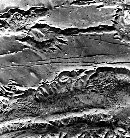 |
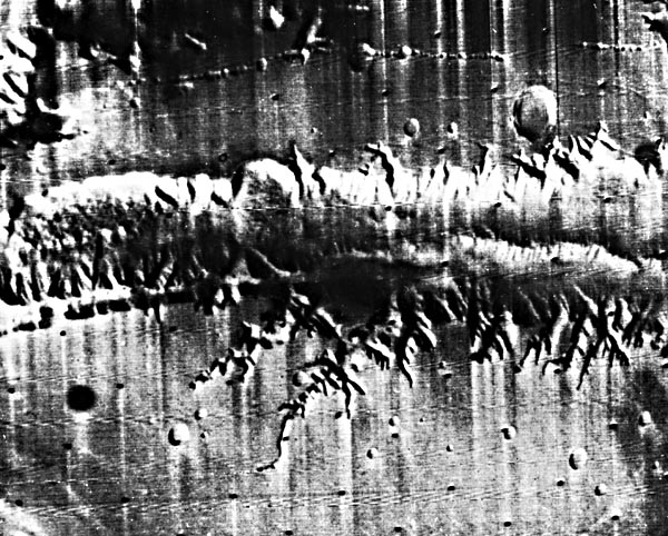
Another section of Ius Chasma (Figure P-7.4), seen in a Viking view, shows the type of tributaries just discussed, but also shows another process by which the main graben has been enlarged (namely, landslides from the north wall). Similar landslides are visible in Tithonius Chasma to the north. These are large features, the area covered by the mosaic being about 300 km wide, and slope retreat by such landslides has clearly contributed substantially to the width of the main canyons. The reader may find it incidentally interesting to compare these undoubted landslides with the ridged terrain northwest of Olympus Mons, for which a landslide origin has also been proposed (Plate P-6). A nonrigorous but perhaps plausible argument against that proposed for the ridged terrain is simply that the landslides in Ius Chasma are instantly recognizable as such, and resemble terrestrial analogs in morphology and regional setting. Another class of feature shown in the Voyager mosaic is the series of east-west trending valleys between Ius and Tithonius Chasmas. These are clearly grabens, occasionally intersected by other grabens, and their location provides further support for the basically tectonic origin of the central part of the Valles Marineris.
The north wall of Ius Chasma, notably at the extreme right of Figure P-7.4, provides an interesting exposure of the subsurface structure of the Martian highlands. Several strata are visible that can be traced for many kilometers to the west (left). Similar strata have been seen on Viking photos elsewhere in the highlands. Their nature is unknown; the obvious possibilities are sedimentary or volcanic layering, or a combination of the two. They appear to be relatively undeformed, with near-horizontal dips, which would be consistent with the general absence of major crustal deformation commented on previously.
Before leaving this unusually interesting scene, we should call the reader´s attention to the crater at bottom center, south of Ius Chasma. The lobate ejecta blanket around what is presumably an impact crater has no counterpart on the Moon or Mercury. 83-H-244.
Continue to Plate P-8| Chapter 10 Table of Contents.| Return to Home Page| Complete Table of Contents|