 |
 |
|---|---|
| Plate T-1 | Map |
|
|
|---|---|
| Plate T-1 | Map |
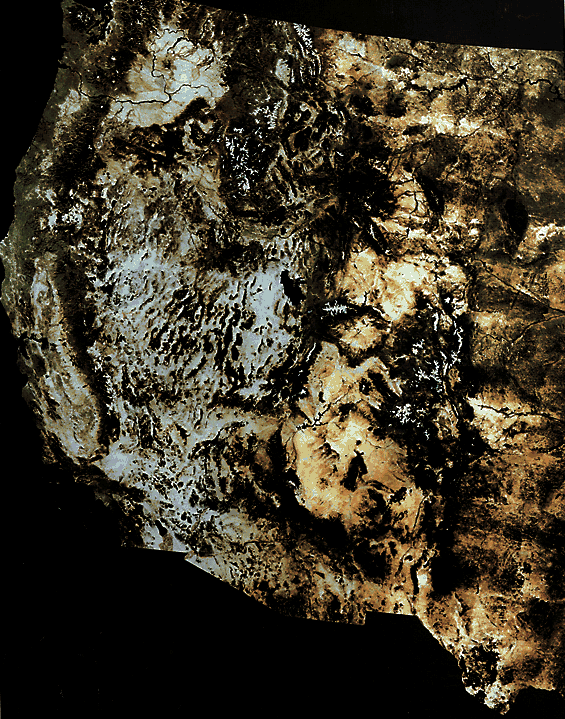
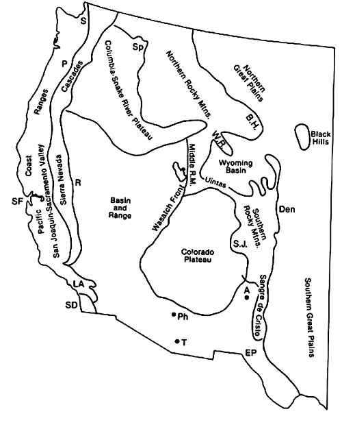
Computer-enhanced Landsat Multispectral Scanner (MSS) images can be joined into mosaics at continental scales. This Plate displays the geomorphology of the western third of the National Geographic Society´s U.S. Bicentennial mosaic (vegetation rendered in natural color by projecting IR band 7 through a green filter). Major physiographic divisions (Hunt, 1974) appear in the index Map. The Plate T-1 serves as a small-scale visual framework for relating present geomorphic expression to the geologic evolution of the Cordillera, synopsized as follows (Condie, 1982; King, 1976; Windley, 1984); and especially Ch. 13 in Suppe, 1985):
1. Development in Late Precambrian of a miogeoclinal clastic sedimentary prism along a trailing continental edge, thickening off craton (west of present Wasatch Front of Utah) as a Proto-Pacific ocean opened (Stewart, 1972); later carbonate deposits through Devonian affected by possible subduction (with polarity reversal) and arc-continent collision in Early Carboniferous (Antler orogeny; Roberts Mountain thrust belt in Nevada); Late Paleozoic block-faulting in Colorado/New Mexico (Ancestral Rocky Mountains)/ Permo-Triassic collision of arcs, eliminating inland basins, during Sonoma orogeny; eastward thrusting (Golconda allochthon) in Great Basin; westward thrusting around Klamath Mountains (Burchfiel and Davis, 1972); cratonic deposits into Cretaceous in eastern Cordillera.
2. Early Mesozoic shift in megastructural trend from NNE to NNW as Pangaea breaks up and North America again moves westward; during Jurassic/Cretaceous, the Kula/Farallon plates subduct under continental margin (inland California today), leading to paired orogenic belts of (1) a western high P-low T Franciscan Group (ophiolites, pelagic sediments, and continental margin turbidites, intermixed as mèlange; also blueschists) and (2) an eastern high T pervasive batholithic assemblage and arc volcanism (160 to 130 Ma) in Sierra Nevada/Klamath regions; forearc basin fill from eroding belts (Great Valley of California) and Coast Ranges affected by westward thrusting atop under-thrust oceanic plate; tectonic climax during Nevadan orogeny.
3. Orogeny intensifies inland during Cretaceous, leading to major eastward thrusting during Sevier orogeny (105 to 75 Ma) along a zone extending through Utah, western Wyoming, and Montana, passing into Canadian Fold and Thrust belt and Alaska; subsequent broad deformation with folding and thrusting during Laramide orogeny (80 to 60 Ma) over most of U.S. and Canadian Rocky Mountains and Mexican Sierras; extensive plutonism in Rockies and southern California/Arizona; basement uplift along thrust faults in Middle and Southern Rocky Mountains forms large mountain blocks and intermontane basins; erosion products build up in basins and Great Plains.
4. Throughout later Paleozoic and entire Mesozoic, much of western Cordillera experiences numerous collisions with oceanic plateaus, arcs, microcontinental fragments, and other terranes rafted on oceanic plates from beyond North America; accretionary terranes expand Cordilleran margin, comprising much of present land masses and causing or moderating orogenies (see also Plates T-9 and T-10).
5. In Cenozoic, most of Farallon plate consumed along shallowing subduction zone; ~ 30 Ma ago, North American plate encounters Pacific plate, whose spreading ridge (East pacific Rise (EPR)) is being progressively overridden; two triple junctions where separated remnants of Farallon plate (Gorda (Juan de Fuca) plate in north; Cocos plate in south) meet the North American/Pacific plate boundary; lengthening boundary becomes Proto-San Andreas (SA) fault where northward spread of Pacific plate initiates right-lateral slip along Mendocino transform; Salinas terrane (Los Angeles sliver) and Baja California detach from North America along SA fault, and Gulf of California opens along decoupling zone; other faults subparallel to continental margin allow various accreted terranes to continue northward movements.
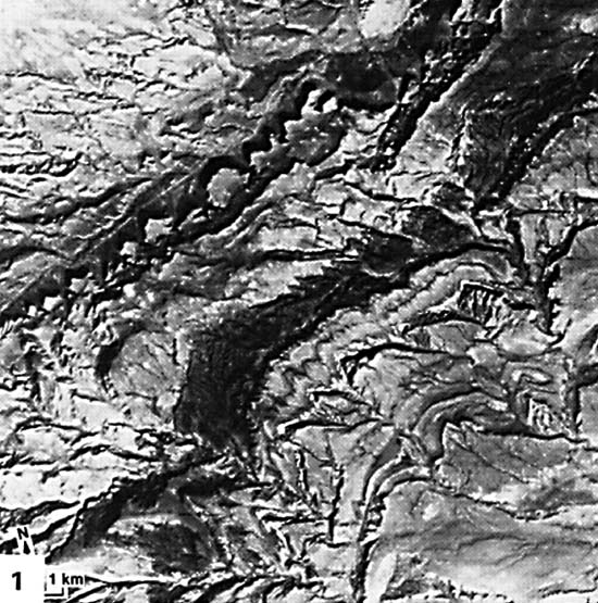
| Figure T-1.1 |
|---|
 |
6. Initial widespread calc-alkaline volcanism in Early Tertiary changes ~ 16 Ma ago to basaltic outpourings in Columbia Plateau; younger basalts in Snake River Plains and silicic lavas over hotspot now beneath Yellowstone; basalt-rhyolite volcanism in Great Basin; Basin and Range begins ~ 19 Ma ago as crustal thinning causes extension, inducing grabens/horsts along normal faults; general regional uplift within Cordillera, including largely undeformed cratonic sediments of Colorado Plateau; calc-alkaline volcanism confined to active subduction boundaries inboard from Cocos (Mexico), Juan de Fuca (Cascades), and Pacific (Alaska) plates.
Figure T-1.1 shows details visible in a computer enlargement of a small part (subset) of a single Landsat frame (Paylor et al., 1985) covering Casper Arch south of the Bighorn Mountains in Wyoming. Homoclinal dipping resistant beds of Pennsylvanian through Cretaceous age give rise to hogbacks and cuestas. Parallel consequent and resequent drainage has developed on the longer dip slopes. (NMS) Landsat Mosaic.
Continue to Plate T-2| Return to Chapter 2 table of Contents| Return to Home Page| Complete Table of Contents