 |
 |
|---|---|
| Plate T-13 | Map |
|
|
|---|---|
| Plate T-13 | Map |
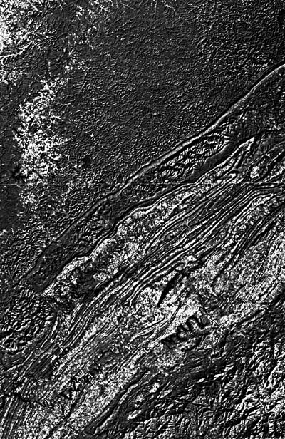
This two-frame mosaic of the northern end of the southern Appalachians further demonstrates the close relationship of topography and underlying structure in this orogen. Three major structural provinces -the Cumberland Plateau to the northwest, the Valley and Ridge, and the Blue Ridge at the southeast corner -coincide with physiographic provinces of the same names. Although the Valley and Ridge Province in Pennsylvania consists of plunging folds in a large anticlinorium, that province here includes numerous imbricated thrust sheets (see index map). The stratigraphic section exposed in this southern segment contains mainly Lower Paleozoic sedimentary rocks; the folds in Pennsylvania include younger units.
Deformation in much of the Appalachians is related to a master décollement zone that extends from under the continental shelf westward below the eastern Appalachian Plateau. Over most of the area, the detachment zone is a sole thrust just above crystalline basement. Imbricated thrust sheets, with east-dipping fault planes, developed progressively westward during at least two episodes of continent/continent convergence (Mid-Ordovician and Late Paleozoic time), carrying successive slices of older rocks over younger rocks. Although deformation in the Valley and Ridge Province is thin-skinned and apparently does not involve basement, it is characterized by folds and faults in the sedimentary cover.
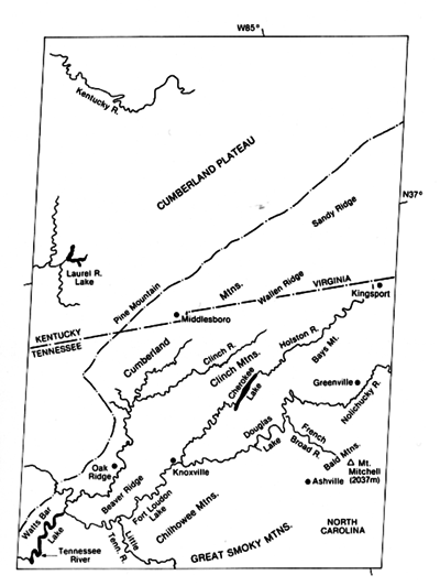
The dominant feature in this scene is the Pine Mountain block, a rectangular structure about 200 km long and 40 km wide, thrust to the northwest along the Pine Mountain fault (PM). The Jacksboro (J) and Russell Fork (RF) strike-slip faults and Wallen Valley (WV) fault further bound the block. The master décollement thrust faults are stratigraphically controlled, rising in abrupt steps at ramps. The thrust planes are concentrated in thick fine-grained sediments of low viscosity and permeability (the Rome Formation, the Conasauga Group, and the Reedsville and Chattanooga Shales).
Topographically, Pine Mountain on the northwest and Cumberland Mountain on the southeast outline the fault block. The scarp slope on Pine Mountain faces northwest, with dip slope to the southeast; the steeper face on Cumberland Mountain faces southeast. The mountains thus form a syncline (the Middlesboro syncline) containing gently dipping Pennsylvanian coal beds. Within this structure is a 9-km circular depression, centered on the town of Middlesboro, that is an astrobleme (eroded impact crater). Southeast of the syncline, the Powell Valley anticline is a broad fold above a structural ramp with Cambro-Ordovician carbonate rocks at the surface. Drilling indicates that the Pine Mountain sole thrust is about 2 km higher under the rootless anticline than east of the ramps.
| Figure T-13.1 | Figure T-13.2 |
|---|---|
 |
 |
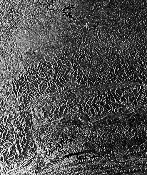
A Seasat radar image (Figure T-13.1) presents a different perspective on the topography in and around the Pine Mountain fault zone (Ford, 1980). In particular, it emphasizes differences in drainage texture between the thrusts and folds to the east and the flat-lying rocks of the Appalachian plateau to the west.
In the Valley and Ridge Province extending northeast across the image, resistant sandstones form strike ridges roughly parallel to the thrust planes. Each successively eastward fault carries older rocks over younger units to the west. These faults probably merge with the master décollement at depth. Numerous cross faults cause offsets or disappearances of ridges. The Great Valley of Tennessee is approximately equivalent to the Shenandoah Valley in northern Virginia; both are controlled by the presence of more erodible limestones.
The southeast corner of the scene shows the Great Smoky and Holston Mountain faults that comprise the northwest boundary of the Blue Ridge Province. The crystalline Blue Ridge block of Precambrian to Lower Paleozoic metamorphic rocks is a single allochthonous thrust sheet 10 to 20 km thick that overrode previously emplaced Valley and Ridge units (visible as whitish terrain in the image where several windows (e.g., Caves Cove) cut through the overlaying thrust).
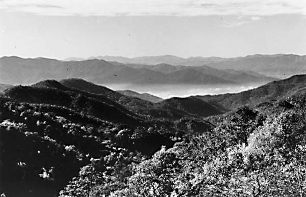
The Smoky Mountains are among the most spectacular in the Appalachians (Figure T-13.2). Mount Mitchell (2037 m) and Clingman's Dome (2025 m) are the highest in the Appalachians. The high relief and dendritic drainage result from deep downcutting into relatively homogeneous crystalline rocks.
Present topography throughout the Appalachians has developed mainly in the last few million years. Although larger streams cross structural units, the landforms in each province are well adjusted to the dominant lithologies and structures on which the drainage networks are imposed. Historic Cumberland Gap, shown as a reentrant on Cumberland Mountain, is a wind gap. Whether it was formed by a north-or south-flowing stream is debatable. (NMS) Additional References: Harris and Bayer (1979), Harris and Milici (1977), King et al. (1968), Rich (1933). Landsat Mosaic.
Continue to Plate T-14| Chapter 2 Table of Contents| Return to Home Page| Complete Table of Contents