 |
 |
|---|---|
| Plate T-22 | Map |
|
|
|---|---|
| Plate T-22 | Map |
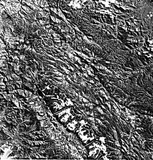
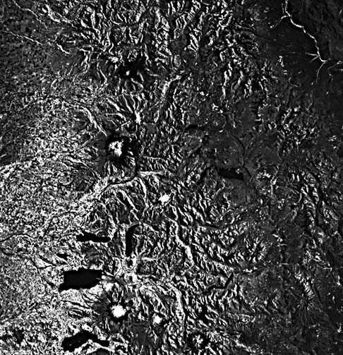
This Plate covers a portion of western Peru in the Western Cordillera. Virtually all of the landforms encompassed by the image can be related to plate interactions. To the west, the Nazca plate is subducting beneath this portion of the South American plate. This action has produced a progression of events well portrayed in the geology and geomorphology of the area. The image shows five distinct northwest-trending morphotectonic bands, which correspond to differing rock types and ages of deformation that ultimately form the spectacular landforms in this segment of the Andes Chain.
The first band, the Cordillera Central, drained by the Rio Huallaga, contains the oldest rocks in the scene. These Precambrian rocks were first deformed in the Middle and Late Paleozoic. Andean tectonic activity subsequently has deformed the same area. This multiplicity of events has so churned these phyllites and schists that they now have a fine-grained nondescript geomorphic texture with only a few through-going structural features. However, one northwest-trending and several east-trending lineaments indicate faults. Separated from the foredeep to the northeast by a thrust fault along the Rio Huallaga, this area experienced the first Andean deformational pulses during subduction of the Nazca plate in this part of South America.
The Rio Marañon flows along a fault trace for most of its length on the image, separating these older rocks from younger, less deformed rocks to the west. Jurassic, Cretaceous, and younger strata dominate this second band of rocks between the Rio Marañon and the Cordillera Blanca farther west. These rocks have been affected by fewer deformational pulses than the areas to the northeast and consequently appear to have more coherent structure that can be traced across the image in the topography. The main deformational event for this region is known as the Inca Phase and spans Middle Eocene to Early Oligocene time. The deformation has produced long northwest-trending folds, as well as a number of east-directed thrusts. Erosion along the thrust traces and less resistant beds has given rise to a geomorphology characterized by long northwest-trending linear mountains with relatively little crosscutting drainage (Figure T-22.1). The area is not as finely dissected as the area northeast of the Rio Marañon.
| Figure T-22.1 | Figure T-22.2 |
|---|---|
 |
 |
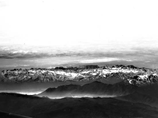
The third morphotectonic band on the image is the Cordillera Blanca. This mountain range, the highest in the area, reaches 7000 m. The Cordillera Blanca is composed mainly of Tertiary intrusive rocks. It is part of the Coastal Batholith, emplaced by generation of magma from the subducting Nazca plate. The intrusive rocks of the Cordillera Blanca have been uplifted along normal faults and glaciated (Figure T-22.2). Some glaciers and a substantial amount of snow still cover the peaks (thus, the name Cordillera Blanca).
The fourth distinct band on the image is sandwiched between the Cordillera Blanca to the northeast and Cordillera Negra to the southwest. This band of mainly Quaternary volcanic rocks comprises most of the eastern portion of the Rio Santa Valley. Referred to as the Callejon de Huaylas, this valley is one of the more densely inhabited and cultivated valleys of Peru. Earthquakes related to subduction of the Nazca plate are frequent destructive events that can cause large mudslides composed of saturated soils derived from the Quaternary volcanic material on the eastern side of the valley. The earthquakes also start snow avalanches that come into the valley from the snow-covered Cordillera Blanca. Close examination of the image reveals several avalanche tracks, the most notable of which is seen in the lower left corner.
| Figure T-22.3 | Figure T-22.4 |
|---|---|
 |
 |
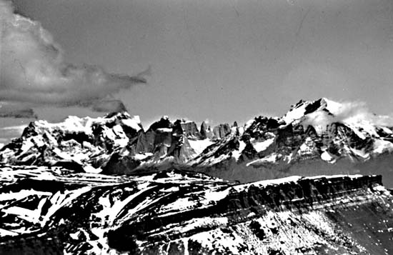
The fifth and southwesternmost band of structures in the Plate image is the Cordillera Negra, seen also from the road to Húanuco (Figure T-22.3). The rocks of this mountain range are mainly Late Cretaceous. Of the units on the image, the Cordillera Negra has experienced the most recent large-scale deformation. In addition to Inca Phase deformation, the Cordillera Negra has undergone a Middle Miocene/Early Pliocene Quechua Phase deformational event. Although folding is common here, with minor amounts of thrust faulting, overall the deformation has progressed less in this area than between the Cordillera Blanca and the Rio Marañon. Characteristically, the western slopes of the mountains have distinct watersheds that drain the area toward the nearby Pacific Ocean. The exposed Andes orogen, where expressed by mountainous terrain, narrows to less than a 200-km width farther to the south in Chile/Argentina (Figure T-22.4). Volcanoes (including V. Lhaima and V. Villarrica) once more become prominent. (GCW: S. J. Prucha) References: Geologic Map of South America (1964), Rutland (1974), Tectonic Map of South America (1978), Zeil (1979). Landsat 2194-14351-6, August 4, 1975.
Continue to Plate T-23 Chapter 2 Table of Contents| Return to Home Page| Complete Table of Contents