 |
 |
|---|---|
| Plate T-3 | Map |
|
|
|---|---|
| Plate T-3 | Map |
One of the major types of interaction that lithospheric plates exhibit is sliding past each other. This happens along transform faults, which are major strike-slip fault systems. These fault zones characteristically exhibit landscapes with linear valleys and ridges and evidence of "drag" of the structural fabric in the area adjacent to the fault zone. In active zones, this structural drag affects very young and transient features, offsetting streams, fans, and ridge spurs. Such an active fault zone may also include sag ponds, small closed drainage basins, and anomalous drainage patterns (Blake et al., 1978; and Ernst, 1981).
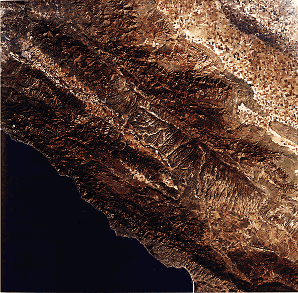
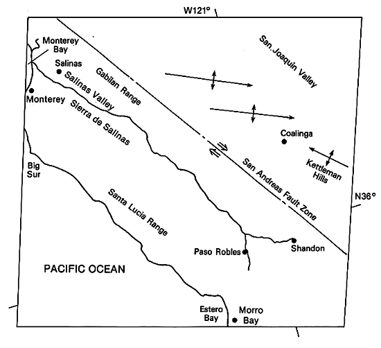
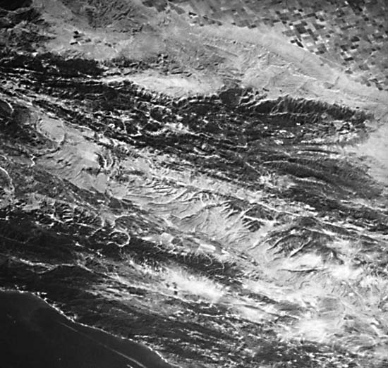
The Thematic Mapper (TM) image of the Coast Ranges of California, which lie along the San Andreas fault between the San Joaquin Valley and the ocean, displays an excellent example of the topography within a major strike-slip zone. (Plate T-2 provides the regional context for this image.) In this active zone, much of the topography, the direct result of movement on the faults, is only slightly modified by erosion. Strike-slip movement commenced in the area as the westward-moving North American plate began to overrun a spreading ridge at about 30 Ma ago (Atwater, 1970). Strike-slip faults joined portions of the spreading ridge lying north and south of the overrun part of the ridge. As subduction of the ridge continued, strike-slip movement extended progressively inland. Through time, movement was concentrated on the Hosgri (off shore), Sur-Nacimiento, and Rinconada fault systems and, finally, the San Andreas (Diblee, 1976; Graham, 1978). Although the majority of movement now takes place on the San Andreas (about 2.5 cm/year), some movement continues to occur on the older zones. After the Coalinga earthquake of 1983, aftershocks occurred along the Rinconada system, as well as the San Andreas.
The main trace of the San Andreas fault zone is clearly visible as a lineament, partly ridge and partly valley, running diagonally northwest across the scene. Figure T-3.1 shows the remarkable linearity and crispness of the San Andreas fault trace in the Carizzo Plain near the southeast corner of the image. The uplifted area is dissected by a system of parallel streams, some of which have been offset by very recent right-lateral movement on the fault. To the east of the fault, elliptical and linear ridge patterns indicate several large folds developed in an area of relatively easily deformed Franciscan basement. These appear to swing into the San Andreas as if dragged. To the west of the fault is the Salinian block with a more brittle granitic basement. West of the San Andreas, numerous linear valleys, which mark fracture traces, also appear to trend into the major fault.
| Figure T-3.1 | Figure T-3.2 |
|---|---|
 |
 |
The northern reaches of the Salinas River occupies a valley that lies between the welt created by the San Andreas on the east and the welt of the older Rinconada/Jolon fault zone to the west. The valley itself probably marks the trace of a major fault. The ridge to the west of the northern section of the Salinas River is an excellent example of a fault scarp with a steep, short northeast face and a gentler western backslope on which longer streams have developed. Some triangular facets (interstream spurs) are also visible along this ridge front, further evidence of its fault origin. The abrupt right-angled change in flow direction of both the San Antonio and Nacimiento Rivers above their junctions with the Salinas is a result of faulting. West of the Rinconada zone is the Sur-Nacimiento zone, a darker area adjacent to the Pacific Coast. This heavily forested region includes numerous outcrops of Franciscan (trench, mèlange, and serpentine) rocks. Even though major strike-slip movement on this zone ceased several Ma ago, the terrain still displays a very strong northeast lineation parallel to the strike of the faults.
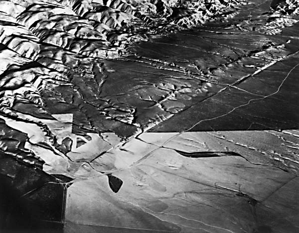
Figure T-3.2 is a view of the Kettleman Hills, a large doubly plunging anticline, seen near the east-central edge of the TM image. The inward-facing cuesta-form ridges outline the edges of the breached anticline. Subsequent strike valleys have formed where less resistant beds outcrop along the dipping strata so that a trellis pattern is beginning to develop. Linear and curved ridges and valleys at the southeast edge of the Cholame Hills (middle distance) illustrate structural drag.
| Figure T-3.3 | Figure T-3.4 |
|---|---|
 |
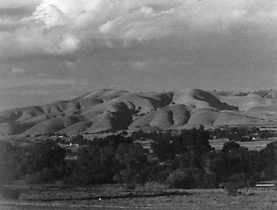 |
Figure T-3.3 is a view of this region taken from the Shuttle. The San Andreas fault zone runs diagonally across the center of the photograph, with several splays toward the upper right corner. The strongly linear topography of the entire region is quite evident.
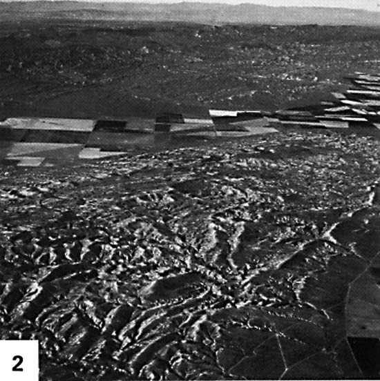
Figure T-3.4 is a photograph looking northeast from the Salinas Valley toward the topographic high west of the San Andreas fault. The streams that drain the upland are "shuttered" right-lateral movement on several small faults paralleling the San Andreas has successively shifted segments of the interstream promontories to the right, creating shutter ridges that obscure, or shut off, the stream valleys from view. (JRE) Landsat TM 40145-18084, December 8, 1982.
Continue to Plate T-4| Chapter 2 Table of Contents| Return to Home Page| Complete Table of Contents