 |
 |
|---|---|
| Plate T-30 | Map |
|
|
|---|---|
| Plate T-30 | Map |
The deformed rocks of the Atlas mountain system (Anti Atlas, High Atlas, and Rif Mountains of Morocco) and the neighboring mountain ranges of southern Spain (Betic Cordilleras) record the collision of Africa and Eurasia-the final stage of the closing of the Tethys Sea. The Atlas system is the only Cenozoic orogenic belt in Africa and, by virtue of the climate, degree of erosion, and contrast in rock types (both in terms of erodibility and spectral response), one of the most spectacularly exposed fold belts in the world. The structures are clearly outlined by the resistant beds because erosion has removed the softer layers. The earliest Alpine deformation began in latest Cretaceous time and continues to the present. Like other Alpine mountain belts, the extreme degree of nappe formation, overthrusting, and folding of platform sedimentary rock attests to the consumption of a substantial (150 km wide at a minimum) section of continental crust in the course of the continent/continent collision (Choubert and Faure-Muret, 1974; Dewey et al., 1973; Manspeizer et al., 1978; Trumpy, 1983; Wildi, 1983).
| Figure T-30.1 | Map T-30.1 |
|---|---|
 |
 |
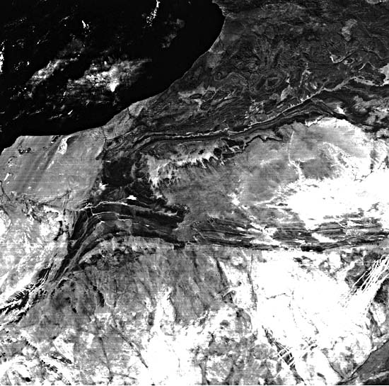
The day-visible band Heat Capacity Mapping Mission (HCMM) image below (Figure T-30.1) provides a regional context for the spectacular Plate scene on pages 96 and 97, taken from the full Landsat image used on the cover of this book. (The small rectangle on the index map tied to the HCMM image shows the location of this image in the region.) The presence of an east-west-trending fault is suggested by the deformation style along a zone that bisects the area shown on the HCMM image for a linear distance of some 640 km. This zone is parallel to the right-slip Agadir fault to the north (Dewey et al., 1973). Offsets in gross outcrop patterns of Saharan platform rocks suggest that this suspected fault, like the Agadir, has at least some component of right-lateral movement. The orientation of the folds, north of Gebel Ouarkziz (well displayed on the color composite), confirms this sense of movement.
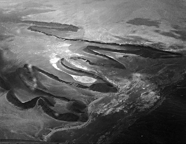
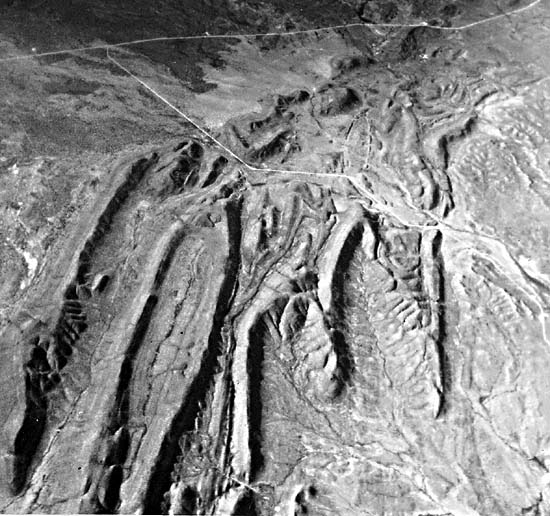
The Plate image displays topographically several characteristics of continental collision orogenic belts. Most obvious is that the rocks are complexly folded and thrust-faulted. Rock sequences are repeated, anticlines encroach upon anticlines, and synclines encroach upon synclines. These exemplify extreme compressive deformation and imply substantial crustal shortening. Figure T-30.2 and Figure T-30.3, aerial photographs taken over the Moroccan Atlas, offer two striking examples of the zig-zag ridges and plunging anticlinal (long, gentle) and synclinal (short, steep) noses formed by resistant rock strata. This style of deformation is common to the layered sedimentary cover of all major fold belts.
| Figure T-30.2 | Figure T-30.3 |
|---|---|
 |
 |
Numerous zones of structural discontinuity or disharmonic folding are particularly obvious in the Plate image. In general, the older rocks to the northwest appear to be more highly deformed than the younger rocks to the south and southeast. The lighter colored yellowish brown Precambrian rocks in the northwest are tightly folded, highly fractured, intruded, and metamorphosed. The high degree of deformation and reorganization of the Precambrian rocks is a function of extreme compression, their deep burial and intrusion, and their greater age. This implies that these rocks might have sustained several periods of deformation before the closing of the Tethys Sea. The younger Cambrian through Silurian rocks are disharmonically folded about this Precambrian core.
There are several zones of disharmonic folding within the Paleozoic sedimentary section. The most obvious zone is the drag-folded Devonian rocks-the narrow band of contorted, intensely folded black rocks that extend diagonally across the center of the image just north of Gebel Ouarkziz. By comparison, the Carboniferous rocks of Gebel Ouarkziz are rather gently deformed and dip to the south, forming the northern limb of a broad synclinorium. The very tight east-northeast-trending folds in the black Devonian rocks north of Gebel Ouarkziz and similar trends of more gentle folds in the Carboniferous and Triassic rocks to the south of the Ouarkziz imply that a major zone of right-lateral transcurrent, or right-slip, movement lies just north of Gebel Ouarkziz. This zone is also parallel to the Agadir right-slip fault to the north and the previously mentioned suspected fault zone to the south (Wildi, 1983).
| Figure T-30.4 | Figure T-30.5 |
|---|---|