 |
 |
|---|---|
| Plate T-40 | Map |
|
|
|---|---|
| Plate T-40 | Map |
This controlled Landsat MSS mosaic includes all or parts of twelve enhanced color-composite scenes that have been geocorrected to Lambert Conformal Conic Projection. The mosaic encompasses southwesternmost Saudi Arabia and the contiguous northwestern portion of the Yemen Arab Republic along the east side of the Red Sea rift. Jizan, Saudi Arabia's major southern Red Sea port, is across from the small tombolo located slightly south of the thin north-south-trending Ras At Taria Peninsula. The major cultivated areas (bright red hues) are developed on the alluvial fan deposits associated with the major drainages. These include Wadi Qadim in the southeast corner, the Najran oasis to the north where the Wadi Najran extends into the southwest corner of the Rub Al Khali, and several wadis on the coastal plain that extend seaward from the Red Sea escarpment. Water from the infrequent rains flows along the intermittent streams (wadis) and, in part, infiltrates the underlying alluvium. These aquifers can be tapped by shallow irrigation wells to provide water for fairly intensive but localized cultivation.
The darker rocks that are exposed in the northwest quadrant and transect the photograph in southeasterly direction form the southern section of the Arabian shield. The old erosion surface (partially exhumed) developed on these crystalline rocks inclines eastward into the Rub Al Khali basin where it can be seen to be overlain by gray and tan alluvial sediments and light brown to light yellow eolian sands. The bold fault-line scarp that separates the Tihama (coastal plain) from the highlands marks one of the major bounding fault zones of the Red Sea rift. The east-northeast slope of the old erosion surface demonstrates the arching and tilting of crustal blocks associated with rifting. Along the right edge of the Plate, the wind-deposited sands tend to be concentrated in local depressions along the eastern margin of the shield or as elongate "seif" dunes farther toward the basin. Along the south edge of the mosaic, deformed Mesozoic sedimentary rocks overlie the basement. Just to the north of the southeast corner, a major northwest-trending fault separates the dark highly jointed crystalline rocks on the north from yellow-brown Jurassic limestones on the southeast.
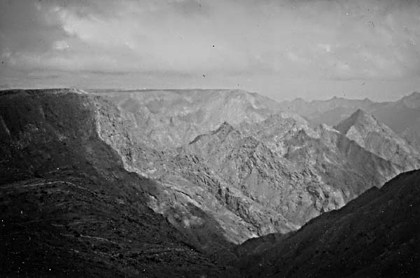
The eroded south-southeast-trending Red Sea escarpment is clearly visible starting slightly below the upper left corner of the mosaic. Elevations along the scarp edge average 2200 m, but local prominences exceed 3000 m (Figure T-40.1). The scarp drops rapidly toward the Red Sea, and elevation averages 30 m where the basement slopes intersect the narrow coastal plain.
| Figure T-40.1 | Figure T-40.2 |
|---|---|
 |
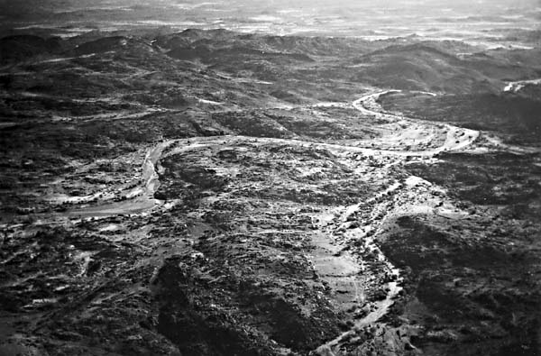 |
Crystalline rocks of the shield consist of complexly folded, metamorphosed, and granitized rocks that are locally intruded by Upper Proterozoic igneous bodies ranging from syenite to gabbro. These intrusions have a regular, near-circular form (see Plutons, Plate T-60). Erosion has reduced parts of the shield to low hills (Figure T-40.2). On the west, erosional remnants of Cambro-Ordovician sandstone locally unconformably overlie the basement; this basement is encroached upon locally by Recent alluvium and eolian sands. The southeast-trending Y-shaped As Sirat volcanic field (harrat) located just to the left of the center of the mosaic provides evidence of the large-scale volcanic eruptions associated with the Red Sea rifting. This is the southernmost and smallest of the 13 flood basalt flows in Saudi Arabia; it covers an area of about 750 km2, and comprises 20 separate flows. Its maximum thickness is 580 m. Isolated volcanic cones are scattered over the lower half of the mosaic area. Those most easily recognized appear as small, very dark, near-circular features superposed on the light-brown Mesozoic limestones.
The coastal plain separating the shield from the Red Sea averages 40 km in width. It consists primarily of fan and terrace deposits composed of silt to gravel-sized clastics and coastal salt-mud flats. Narrow, shallow coral reefs closely parallel much of the southern shoreline.
The islands in the southwest corner are part of the Farasan Group. The coral reefs that comprise these islands grew over salt domes and were subsequently uplifted. (GCW: H. Blodget) References: Al-Shanti (1979), Brown and Jackson (1959), Geukens (1966). Landsat Mosaic.
Continue to Plate T-41| Chapter 2 table of Contents| Return to Home Page| Complete Table of Contents