 |
 |
|---|---|
| Plate T-44 | Map |
|
|
|---|---|
| Plate T-44 | Map |
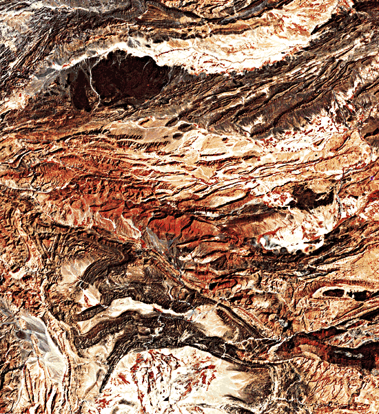
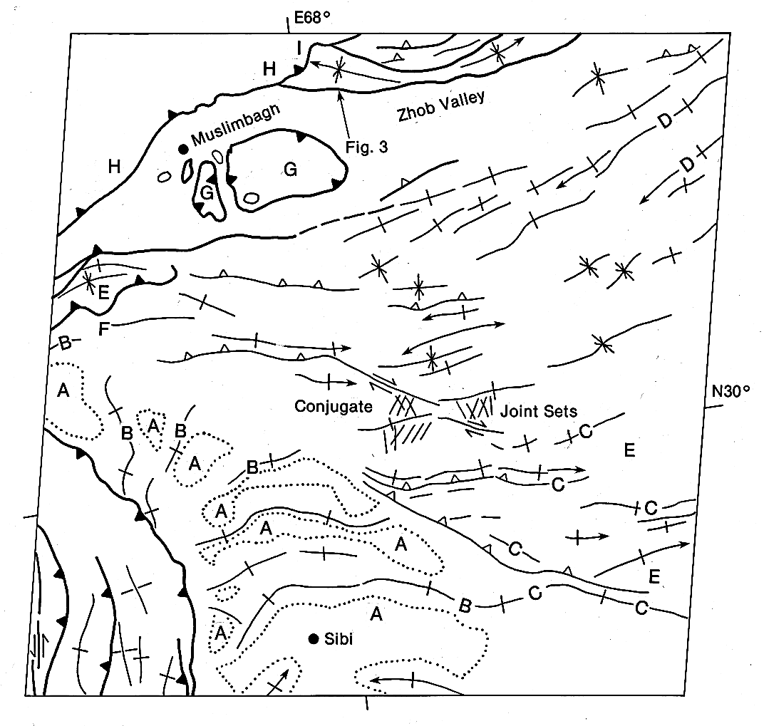
This and the next two Plates show different aspects of the tectonic effects of the collision between the Indian subcontinent and Eurasia. The collision was frontal in the Himalayas, but in the Kirthar and Sulaiman Ranges of western Pakistan, it was oblique. Assessment of deformational styles shown in Plates T-44 and T-45 (Zhob Valley and Zinda Pir) indicates that oblique collision there resulted in a structural complexity greater than that found in the foothills of the Himalayas (Plate T-46, Kohat). In an oblique collision zone, such structural complexity may be expressed by major strike-slip faulting, overprinting of tectonic domains, and drastic changes in the direction of thrusts and folds over short distances. All of these features can be seen in this Plate.
The city of Sibi is located in a small undeformed basin, presumably the westernmost outlier of the undeformed Indian subcontinent. West of the basin, thrust sheets moved eastward, which is the typical transport direction in the north-south-oriented Kirthar Range. In the extreme southwest corner of the Zhob Valley image is a fault parallel to a group of three or four faults farther west that repeat the sinistral motion along the Chaman fault. The fact that this is an active group of faults is demonstrated by a series of earthquakes (30000 killed in Quetta in 1935). Combined, the two transport directions, eastward-thrusting and sinistral strike-slip along north-south-oriented faults, indicate northwest motion of the subcontinent with respect to the Afghan block.
| Figure T-44.1 | Figure T-44.2 |
|---|---|
 |
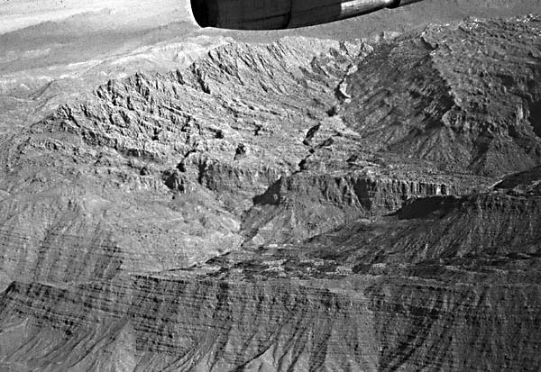 |
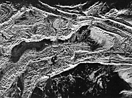
North of Sibi is the Sibi Trough, a triangular area with broad basins (A) separated by narrow tight folds. Details of the intricacies of these fold patterns are strikingly revealed in a SIR-A radar image (Figure T-44.1). The youngest deformed rocks are Pleistocene (Figure T-44.2, Mount Zarghun, 3615 m), implying that this is a trough in the process of being deformed. The accumulation of sediments continues in the southern basins around Sibi. Visible in some of the narrow anticlines are whitish Middle Eocene limestones (B); they, together with the overlying red bed sequence, are detached with respect to the lower strata. The detachment horizon is in Lower Eocene shales. Northeast of the Sibi Trough, Lower Eocene, Cretaceous (C), and Jurassic (D) rocks are exposed in the cores of doubly plunging folds, thus demonstrating that another, much deeper zone of detachment exists in this area. The folds contrast with those of the Sibi Trough, having broad anticlines and narrow synclines; such anticlines farther to the southeast host the major gas occurrences in Pakistan (e.g., the Sui gas field, located in the southernmost anticline visible in the Landsat image just to the southeast (Figure T-44.3). In the southeast corner of the Zhob Valley Plate, complex structures (E) between the broad folds attest to the role of the Lower Eocene shales as a detachment horizon higher in the section.
All deformation discussed thus far is of Late Tertiary, Pleistocene, or even Recent age. Farther to the north, however, spectacular examples of older deformation are visible. For example, near the apex of the Sibi Trough, the existence of a thrust fault can be inferred from the repetition of Paleocene limestone (F) (Kazmi, 1979). The upper slab has been partially eroded and is discordantly overlain by Miocene red beds, which, together with the underlying thrust sheet, are folded in an anticline and syncline. The folds are cut off by a Late Tertiary or Pleistocene thrust fault overlain by a unit with two huge slabs of dark (almost black) rock (G). These are ophiolites, originally part of the mantle and oceanic crust that once separated Eurasia from the subcontinent. The ophiolites were thrust upon the continent before the collision, but not later than Paleocene, since they are overlain by white limestones of Early Eocene age (Abbas and Ahmad, 1979). The ophiolites are underlain by mélanges, chaotic deposits which contain large ophiolitic blocks that are visible in the Landsat image.
| Figure T-44.3 |
|---|
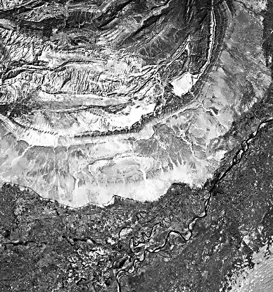 |
North of Muslimbagh (meaning Garden of Muslims; bright red in the Plate), both Eocene rocks and ophiolites are caught in imbricate thrust slices beneath the major thrust fault of the area, the Zhob Valley thrust (H). This fault juxtaposes Tertiary marine rocks, similar to those in the Makran (see Plate T-43), with continental red beds, also of Tertiary age. The marine sediments had been deposited in the gulf between the Afghan block and the advancing subcontinent before they were underthrust by the latter. The telescoping of two different facies domains was preceded by folding, as can be deduced from the syncline that is cut by the Zhob Valley thrust (I). (GCW: K. A. DeJong) Landsat 30212-05203, October 3, 1978.
Continue to Plate T-45| Chapter 2 table of Contents| Return to Home Page| Complete Table of Contents