 |
|---|
| Plate T-48 |
|
|---|
| Plate T-48 |
 |
|---|
| Map |
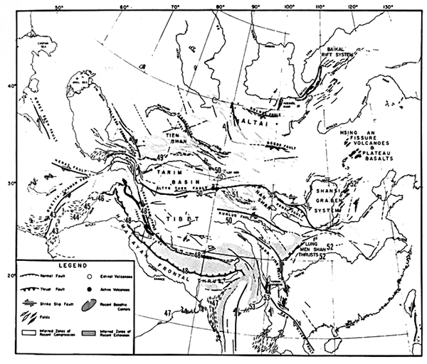
The most profound deformational event involving the interaction of lithospheric plates is the collision between continents. The Indian continent began to impinge on the Eurasian continent in the Eocene. The continuing northward compressional movement of India has produced intracontinental thrust sheets responsible for the highest mountains in the world. Mount Everest, the Annapurna Range, and the rest of the Himalayas are still rising, and the region remains seismically active. The effects of this collision are extraordinarily widespread, being responsible for the 2500-km long thrust front of the Himalayas (see Figure 2-2) that extends from the Hindu Kush (Plate T-43) on the west to the Burma Ranges (see Figure T-48.9) on the east and for the creation of tectonically bonded intramontaine basins (e.g., Kashmir and Katmandu) developed on the back slopes of the frontal thrusts. In addition, the collision is still producing strike-slip faulting far into western and central China, as well as along the Red River fault of southwest China and Vietnam (Plate T-53) and normal faulting on the Lake Baikal (Plate KL-14) and Shaanxi graben (Plate T-52) systems. The collision has led to 60 to 80 km of crustal thickening beneath the Tibetan Plateau, an area of 600 by + 1000 km, which provides the buoyancy in part necessary to maintain the plateau at an average of 4 km above sea level (Lyon-Caen and Molnar, 1985).
| Figure T-48.1 |
|---|
 |
| Figure T-48.2 |
 |
Much of our understanding of the geometry and kinematics of this widespread deformation is derived from studies of Landsat mosaics and their integration with available geologic and geophysical data (Molnar and Tapponnier, 1975, 1978; Ni and York, 1978; Tapponnier and Molnar, 1976, 1977, 1979; Tapponnier et al., 1982). Space imagery is virtually the only tool available to visually span the regions affected by this vast deformation. Other Plates in this chapter that include elements of this widespread deformation field are T-43, T-44, T-45, T-46, T-49, T-50, T-51, T-52, and T-53, whose locations are plotted on Figure 2-2.
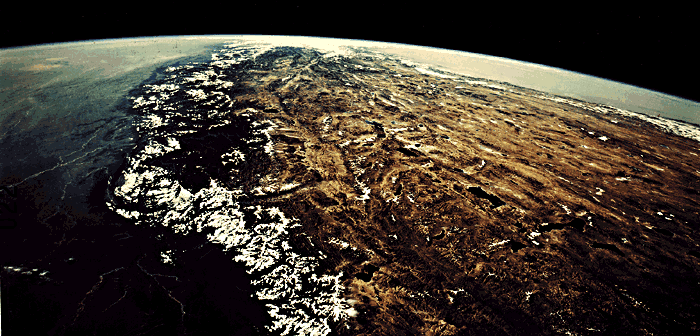
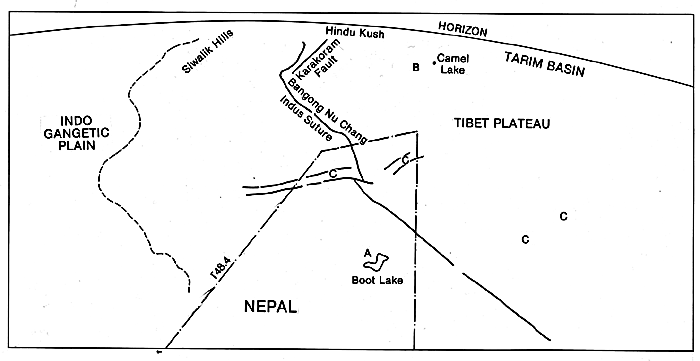
On the facing page is a spectacular hand-held camera photograph taken during Shuttle Mission S-17 from a point almost directly above Mt. Everest looking northwest to the Hindu Kush (snow-covered peaks near the midhorizon). (A "boot-shaped" lake (A) is a useful reference in locating several other figures in this Plate.) The Indo-Gangetic Plains (bluish-green), at less than 100 m average elevation, lie to the left, and the haze-filled Tarim Basin occupies the right half of the horizon (see index map below Plate). Over much of the Himalayas, topography strongly mirrors underlying structure. The light- to dark-green transition on the left roughly marks the edge of the Himalayan deformation front and the approximate location of the Main Boundary Fault (Gansser, 1974). Snow delineates the higher Himalayas (many peaks being greater than 7500 m, with Mt. Everest rising to 8848 m); the southern margin of the snow crudely follows the trace of the Central Thrust of the Himalayas.
| Figure T-48.3 | Figure T-48.4 |
|---|---|
 |
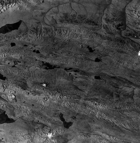 |
In the Plate, the extensive area of light-brown (tawny) terrain containing scattered lakes that indicate closed drainage basins is the youthful topography of the Tibetan Plateau. Deformation and uplift, although strong, are so recent that much of the plateau lacks an integrated drainage system. Linear ridges mark fold and thrust belts; faults control many of the linear valleys. The very straight valley near the horizon is cut along the Karakoram fault zone (right-lateral); the Indus suture, or Bangong Nu Chang, representing the collision boundary between India and Asia (Crawford, 1974), occupies a wide light-colored valley that runs diagonally across the photograph. Several straight graben valleys, some containing lakes, trend northward transverse to major compressive features. Other lakes collect in low spots along active strike-slip faults or in valleys dammed by recent volcanic material.
Figure T-48.1 (Large Format Camera photograph 0534) pictures a segment of the Himalaya front from the syntaxis near Islamabad, Pakistan, to Simla, India. The Main Boundary Thrust (MBT) of the Himalayan front marks the boundary between the low relief and relatively gently deformed Tertiary rocks of the highly cultivated Punjab plain and the folded and thrust-faulted Tertiary rocks of the Siwalik Hills (darker toned (forest-covered) topography), beyond which are the more highly deformed Lower Paleozoic and Mesozoic rocks of the lower Himalayas. Most of the Punjab plain is at an altitude of about 100 m, whereas the cloud-covered peaks to the north are above 6000 m (6 km or more of relief over a 60-km horizontal distance). Actually, topographic relief along the front is even more abrupt, with elevations rising to 2500 m in less than 10 km. Discrepancies between land surveys based on celestial and ground measurements in the vicinity of this impressive topographic discontinuity led to an awareness of gravity anomalies and the development in the last century of the Airy and Pratt theoretical models for isostasy.
| Figure T-48.5 | Figure T-48.6 |
|---|---|
 |
 |
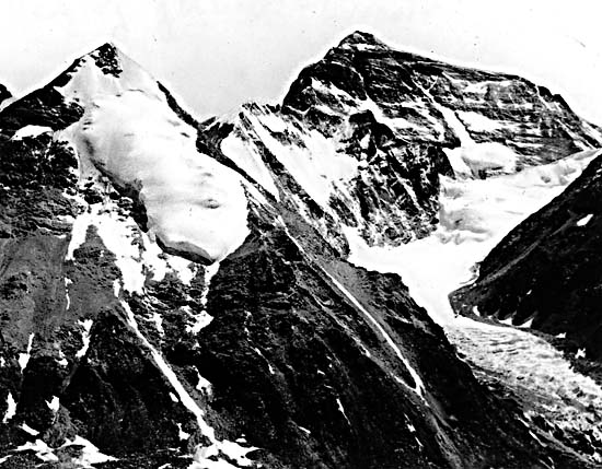
Another LFC photograph (Figure T-48.2) is a vertical view of much the same area as shown in the center foreground of the Plate photograph (the boot-shaped lake, center of the LFC view, is a good tie point). The scene extends across the main Himalaya in Nepal to the Siwalik Hills and Indo-Gangetic Plain (lower right), with its center about 1500 km southeast of Figure T-48.1. Mt. Everest appears in the photograph toward the upper right. Terrain typical of the Everest region appears in Figure T-48.3.
| Figure T-48.7 |
|---|
 |
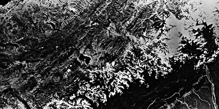
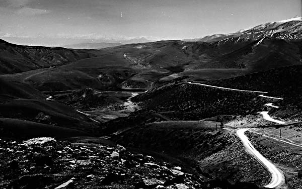
Despite the great elevations of the Tibetan Plateau, the comparatively gentle topography of much of this plateau (Figure T-48.4 (Landsat) and Figure T-48.5 (ground)), except near its northern and southern margins and in several ranges such as the Tengulla Shan (Figure T-48.6) that lie within it, is strong evidence for recent uplift. Paleontological evidence suggests that most of this uplift is post-Miocene. Indeed, the region is still rising, some places at rates greater than 1 cm per year (Lyon-Caen and Molnar, 1985). Many of the circular features that dot the plateau are young volcanoes (e.g., southeast of the boot-shaped lake in Figure T-48.2) or recent intrusions. Both attest to the geologic youthfulness of the region.
| Figure T-48.8 |
|---|
 |
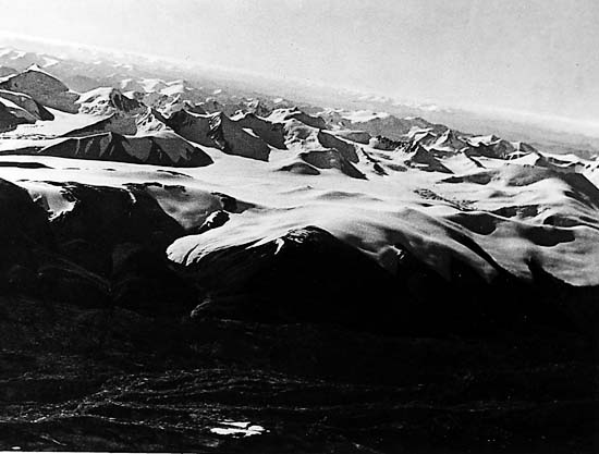
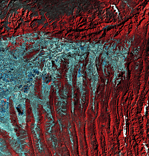
The Kunlun Mountains (see Plate T-49) are another range that divides the Tibetan Plateau. The Kunlun fault, seen in Figure T-48.7, is one of the most active in the Himalayan region. Kidd and Molnar (personal communication, 1985) found evidence, based on pyroxenite clasts in a glacial till, of 27 km of Pleistocene left-lateral movement (a rate of 1 to 3 cm per year). Gash crevices along the fault are deep enough to conceal a standing man (Kidd, personal communication, 1985). The linear fault valley and the "drag" of geologic features into the fault are excellent examples of topography developed along a major strike-slip zone. Topographic relief between snow-covered peaks in this LFC scene and the Qaidam basin to the north (see Plate T-51) is about 5000 m.
Several of the large active faults (Rothery and Drury, 1984) in the Himalaya orogen are evident in the oblique photograph taken from the Shuttle (Figure T-48.8) looking toward the north-northwest. The low look-angle and the snow cover help to make these stand out. The northwest-trending linear valley (occupied by the upper Indus River) traversing the entire frame follows the trace of the right-lateral Karakoram fault (Molnar and Tapponnier, 1975, 1977).
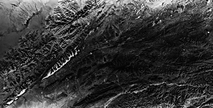
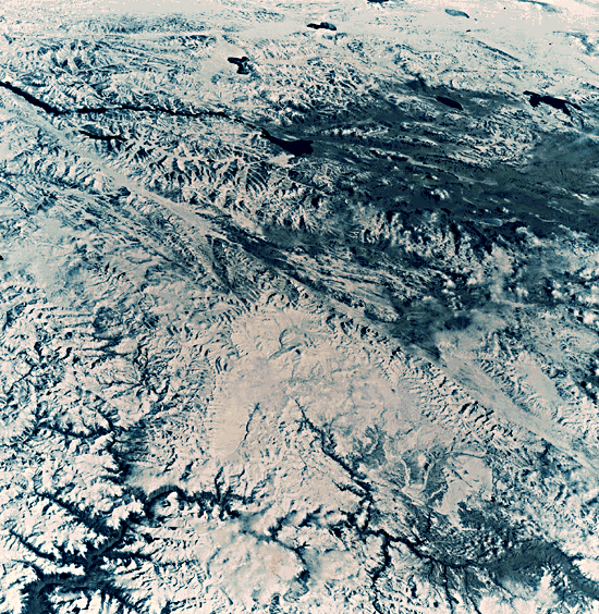
Figure T-48.9, which straddles the intersection of the Himalayan front and the Indoburman ranges, shows a juxtaposition of tectonic styles. The beautifully developed north-trending décollement folds of the Chin Hills end abruptly against the thrust of the front. The right-angle intersection of the two sets of compressive features, of approximately the same age, is a consequence of the clockwise rotation of India as it plowed into Asia. The same collision was responsible for both the Himalayan and the Chin Hills deformations.
| Figure T-48.9 | Map#2 |
|---|---|
 |
 |
The forested finger-like anticlines that comprise the Chin Hills stand out in this Landsat scene, in stark contrast to the highly cultivated synclinal lowlands. Individual lithologic units of Tertiary age making up the folds are traceable for substantial distances along the strike. To the east, the folds become tighter, and westward-directed thrusting increases. The detachment zone is probably a series of shales that immediately overlie the basement; the folds are produced as the Upper Cretaceous and Tertiary rocks are scraped off the Indian craton while it is being subducted beneath Asia.
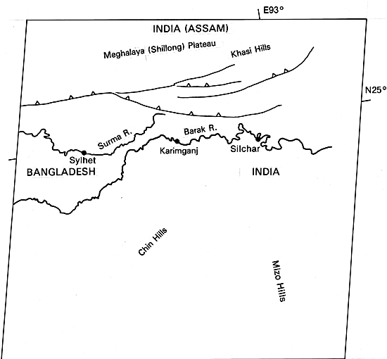
The Khasi Hills and Meghalaya Plateau are an uplifted Precambrian crystalline complex (part of India). These rocks were eroded to a very low-relief surface before the beginning of uplift. Much of the older erosion surface is still intact, and many features characteristic of planation surfaces in shield areas are visible. Only the southern portion of this uplifted shield, adjacent to a large southward-directed frontal thrust, has begun to undergo erosion. The freshness of the little-eroded upland surface implies very recent (Pleistocene) uplift. This fresh appearance is particularly remarkable in that the town of Cherrapunji, in the hills north of Syhlet, receives the largest recorded annual rainfall of any place on Earth. Folded alluvial fans suggest that thrusting continues today. (JRE) STS-17-120-022.
Continue to Plate T-49| Chapter 2 table of Contents| Return to Home Page| Complete Table of Contents