 |
|---|
| Plate T-50 |
 |
| Plate T-50a |
|
|---|
| Plate T-50 |
|
| Plate T-50a |
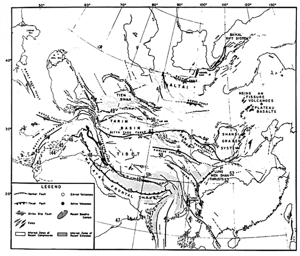
The Tibetan Plateau has been the site of convergence and collision of northward-drifting island arcs and continental fragments since the Late Paleozoic (Dewey and Burke, 1973; Zhang and Lieu, 1984). These events culminated in the Late Eocene with the closure of the southern Tethys Sea and the consequent collision of the Indian Continent against the underbelly of Eurasia (Gansser, 1974). This collision, which continues today, has produced a belt of deformation that covers an area of over 20° latitude by 70° longitude in central and eastern Asia.
The neotectonic regime of central Asia (see Figure 2-2), including most of the Tibetan Plateau, is dominated by a series of gigantic left-lateral strike-slip faults that are moving successively more southerly slices of Asia eastward away from the northward-advancing Indian plate (Molnar and Tapponnier, 1975). The north-south-oriented normal faults and southeast- and east-northeast-trending strike-slip faults that are characteristic of the Tibetan Plateau accommodate this regional north-south shortening and eastward translation (Molnar and Tapponnier, 1975; Rothery and Drury, 1984).
| Figure T-50.1 | Map T-50.1 |
|---|---|
 |
 |
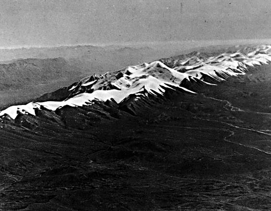
Mean elevation of the Tibetan Plateau is about 4000 m and locally exceeds 7000 m. The Uula-Muztag, approximately 50 km south of the scene, reaches an elevation of 7724 m. To the north of the Plateau, elevation within the Tarim basin drops to approximately 1000 m.
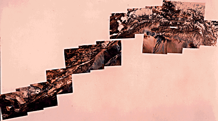
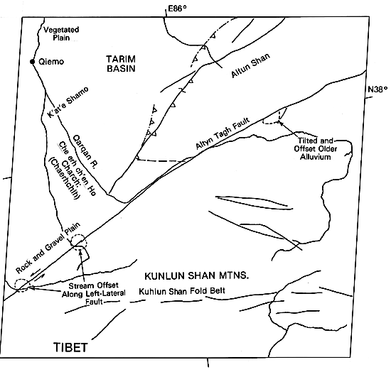
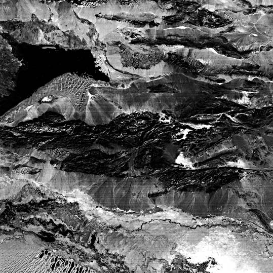
The Altyn Tagh fault is the most prominent fault of Tibet and western China, extending more than 1500 km from the Karakoram to the Nan Shan. Meeting the Kansu fault in the east, it is part of an even larger system that extends over 2500 km and defines the margins of many of the largest basins and uplifts in central and western China. About two-thirds of the Altyn Tagh fault can be followed in the color mosaic in the upper half of this Plate (next pair of pages). Older igneous and metamorphic rocks are exposed along this fault and presumably continue beneath the Tertiary and Quaternary fill of the Tarim basin.
The Large Format Camera photograph in the lower half of the Plate shows a segment of the Altyn Tagh fault about 500 km west of the center of the mosaic image. The large and small folds north of the main trace of the fault suggest that there is a substantial amount of compression across the fault and perhaps a considerable thrust component to movement at this locality. The snow-covered mountains of the Tibetan Plateau tower 5000 m above the Tarim Basin. The numerous closed basins (lakes) and complex pattern of ridges on the plateau (west end of the Kunlun fold belt) attest to recent deformation.
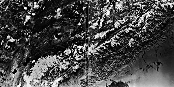
Considerable evidence for recent movements along the Altyn Tagh fault is apparent from looking at details visible in an individual Landsat image (Figure T-50.1, located near middle of mosaic). Note in particular the discrete linear traces of the fault, the juvenile erosional patterns of adjacent uplifted areas, the left-lateral offset of minor drainage that crosses the fault, and the tilted alluvial terraces along the fault. The Tarim basin lies north of the fault. This isolated rigid block is surrounded on all sides by active intraplate orogenic zones. Compression and depression dominate along the northern margin of the Tarim basin, and strike-slip motion prevails along its southern margin, with the result that the entire basin has tilted northward. South of the Altyn Tagh fault is an area characterized by broad alluvium-filled valleys and narrow, subparallel, and highly elevated ridges. These ridges consist of folded and fault-bounded sedimentary rocks; the faults exhibit a combination of strike-slip and dip-slip movement.
| Figure T-50.2 | Map T-50.2 |
|---|---|
 |
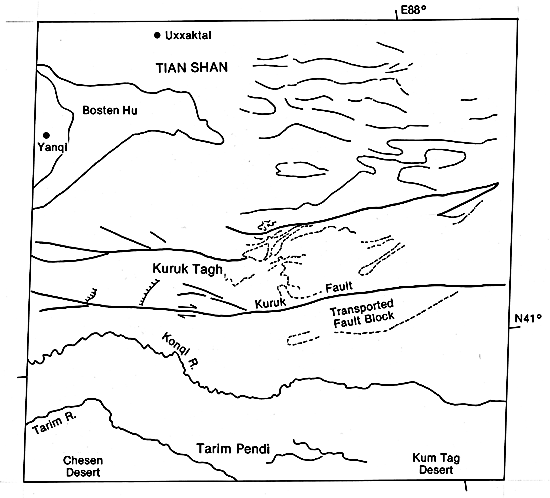 |
The most prominent features situated along the southeastern margin of the Tian Shan in westernmost China on the north side of the eastward-moving edge of the China block are the Kuruk Tagh uplift and the Kuruk Tagh fault. The discrete trace of the Kuruk Tagh fault is seen on a Landsat image (Figure T-50.2) where it cuts through folded and metamorphosed Late Paleozoic (?) rocks. The fault trace is sharp and straight, implying a large component of strike-slip motion. The crispness or freshness of the fault trace, disruption of drainage across this fault (e.g., alluvial fans displaced from major streams), and abruptness of relief across this fault line indicate that the Kuruk Tagh fault is currently active. Detached structural blocks, such as the small detached anticline in the western part of the image, also suggest recent movement on the fault.
The Kuruk Tagh fault, which extends for over 250 km in an east-west direction, is only one of several such faults in the Tian Shan. Offset of streams and fans across the fault, "drag" of the tectonic fabric of rocks adjacent to the fault, and displacement of lithologic blocks across the fault demonstrate right-lateral movement. Right-lateral movement along the Kuruk Tagh and similar faults probably began during the Oligocene, with the rate of movement displacement progressively increasing since then. Right-lateral displacement on these faults is part of the kinematic pattern that has accommodated the eastward movement of crustal blocks in the southeastern Eurasian continent away from northward-moving India since the initial Eocene collision.
The Bagrash Kol depression (northwest portion of image) is one of several large east-west elongated depressions on the eastern Tian Shan that resulted from the interference between dominant right-lateral strike-slip faults and subordinate left-lateral strike-slip faults.
| Figure T-50.3 | Figure T-50.4 |
|---|---|
 |
 |
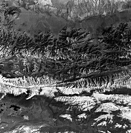
Earthquake solutions and evidence from Landsat imagery to the east and north of the Kuruk Tagh suggest that many of the faults bounding the individual block uplifts are actually reverse faults (Tapponnier and Molnar, 1977). The recent and continuing uplift of these blocks is attested to by the active system of steep alluvial fans that flank most of the uplifts.
To the south of the Kuruk Tagh are the vegetated floodplains of the Kuruk and Tarim Rivers. Farther to the southwest in this Landsat scene is the northern edge of the Cherchen Desert, which occupies the easternmost portion of the Tarim basin. Note the well- developed compound crescentic dunes and interdune lakes.
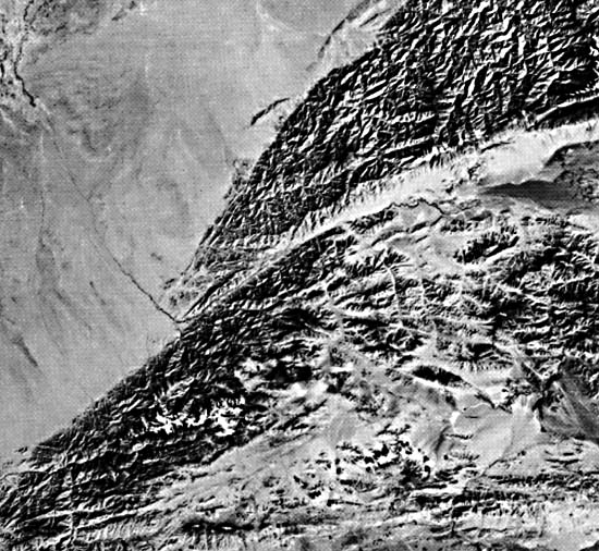
The Kunlun fault (Figure T-50.3) and the Kunlun Mountain belt (Figure T-50.4) roughly parallel the eastern half of the Altyn Tagh fault system to the north. This, too, is another strike-slip fault with pronounced left-lateral displacement. The Landsat image shows the Kunlun fault near its western terminus; note the subsidiary faults running in much the same directions. (GCW: R. C. Michael) Additional Reference: Bally et al. (1950). Large Format Camera 168, October 6, 1984.
Continue to Plate T-51| Chapter 2 table of Contents| Return to Home Page| Complete Table of Contents