 |
|---|
| Plate T-55 |
|
|---|
| Plate T-55 |
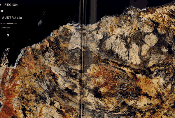
The remarkable mosaic reveals the influence of erosion on the Precambrian rocks of an ancient continental shield in a vegetation-sparse environment. The correspondence between different outcrop patterns visible in the mosaic and their counterpart to geologic units is evident when they are compared with the geological map of this part of (northern) Western Australia.
| Map T-55 | Map T-55a |
|---|---|
 |
 |
Ages of exposed rocks range from Early Precambrian through Permian (P), Cretaceous (K), and Tertiary (T), with widespread Quaternary (Q) cover in coastal regions. Because soils are generally thin, the structure of the bedrock exerts a strong control on surface morphology. The region has had a complex history of deposition, volcanic extrusion, deformation, metamorphism and intrusion, and periodic uplift.
| Figure T-55.1 | Figure T-55.2 |
|---|---|
 |
 |
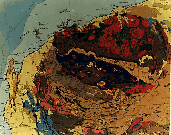
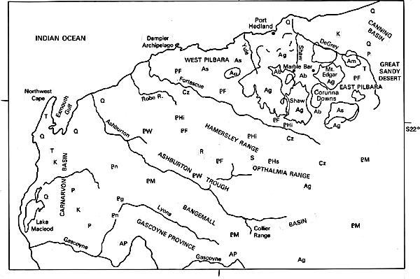
Much of Western Australia consists of a crystalline shield terrane. The Yilgarn Block, a large structural unit, extends from the southern coast of Australia to a line south of the Gascoyne River just below this mosaic. Rocks as old as 3.5 Ga are found in this cratonic segment. Essentially coeval rocks compose the Pilbara block, whose surface appearance is dramatically displayed in the upper part of the mosaic. Elsewhere, unconformable Lower Proterozoic units (Mt. Bruce Supergroup; 2.3 to 2.4 Ga) fringe the Pilbara Block and also lie to the south in the Nullagene (Hamersley) basin, which contains the Hamersley and Opthalmia Ranges. These units (Fortescue Group), labeled PF in the index map, are mainly metamorphosed felsic volcanic rocks, basalts, and sedimentary deposits. Widespread units marked PHi and PHs represent the Hamersley Group, rich in jaspilite (Banded Iron Formation), that comprises one of the world's great iron reserves, and sandstones, shales, and carbonates. The youngest units are conglomerates of the Wyloo Group.
The Ashburton Trough contains metasediments and basalts (PN, PW) of ages between 1.9 to 2.0 Ga. Farther south, the extensive Bangemall basin contains sandstones, shales, and cherty carbonates (PM) deposited from 1.1 to 1.0 Ga ago. Wedged between the Yilgarn Block and this basin are older migmatites (AP) and metasedimentary rocks (Pn) of the Gascoyne Province. On either side of these ancient Precambrian blocks are younger depositional basins: the Late Paleozoic/Mesozoic Carnarvon basin and Mesozoic Canning basin. Cenozoic deposits (Cz) inland around the Fortescue River, derived from older units (especially the Fortescue jaspilites), include a variety of ferruginous deposits (pisolites, laterites, opaline limestones, and ferricrete).
| Figure T-55.3 | Figure T-55.4 |
|---|---|
 |
 |
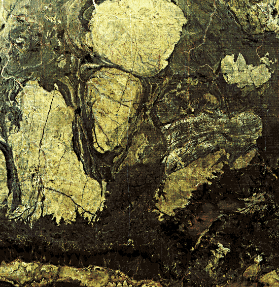
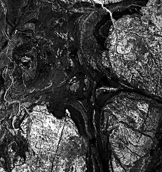
The Pilbara Block stands out as perhaps the best exposed example of an Archean granite (Ag; Am)-greenstone (Ab) terrane anywhere on Earth. Here, the light-toned Granitic Complex (actually tonalites, granodiorites, and adamellites) consists of batholiths emplaced as diapirs into the dark-toned greenstones (Figure T-55.1, an outstanding Landsat scene). These consist of the metamorphosed Warrawoona Group, a collection of volcanic lavas (basalts, andesites, and rhyolites), ultramafics, and sedimentary rocks (jaspilites, volcanic clastics, and cherty carbonates), and the overlying Mosquito Creek Group, another volcanic/jaspilite/shale sequence. The pregreenstone assemblage accumulated in shallow water filling an extensive trough along a belt developed by rifting (?) of thin crust. The greenstones have radiometric ages of 3.45 to 2.85 Ga. The batholithic intrusions have Rb-Sr ages of 2.9 to 3.0 Ga, attributable to the time of metamorphism when they were emplaced as gneissic domes. Although melting phenomena are present, some workers believe that these granitic rocks are older (ages now reset) basement that was reactivated during the formation of the dome structures. The Fortescue Group accumulated after the crust stabilized to form the Pilbara Block.
| Figure T-55.5 | Figure T-55.6 |
|---|---|
 |
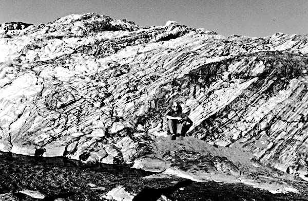 |
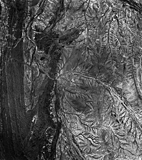
Figure T-55.2 is a computer-enhanced version of part of a Landsat frame that shows in more detail the batholiths and intervening greenstone units. Compare equivalent parts in this version with the 1:86000 aerial photograph (Figure T-55.3) of the northeast corner of the Shaw intrusive and adjacent greenstone belt (in which light units are quartzites and cherty metasediments). Tributary drainage of the two eastern blocks is pinnate. Note the basaltic dikes that fill many of the major fractures.
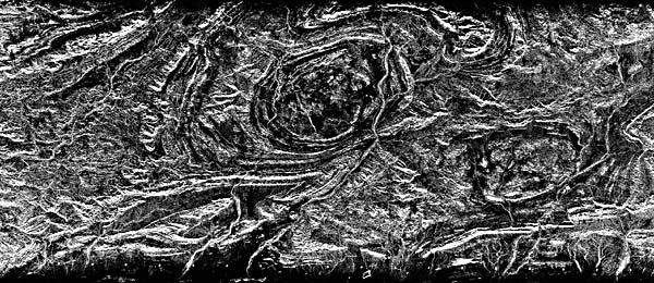
A SIR-A radar strip (Figure T-55.4) emphasizes the structural control of the terrain across the south-central Hamersley Range. The Rocklea Dome (R) has an Archean granite core, but most other rocks are Proterozoic. Plunging synclines occur at S. The domes are outlined by annular drainage, but major rivers disregard the structure.
| Figure T-55.7 | Figure T-55.8 |
|---|---|
 |
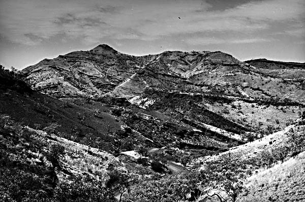 |
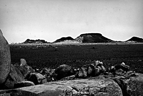
Topography throughout northern Western Australia is varied but generally of low relief. Elevations reach a maximum of 1235 m at Mount Bruce in the Hamersley Range. The Pilbara Block is generally flatland, with low ridges among the greenstone. Ridges and hills dot the Hamersley Range. Desert sand cover is conspicuous in the eastern section of this mosaic.
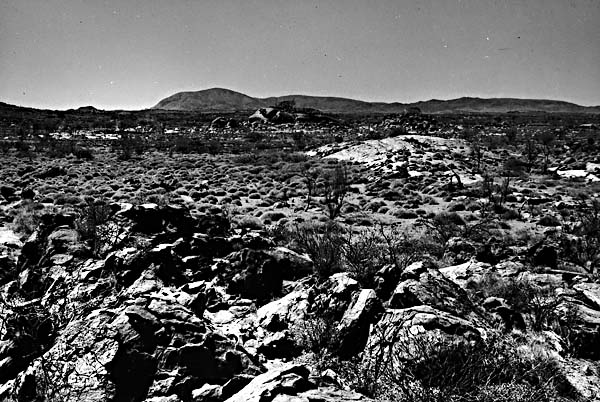
Figure T-55.5, Figure T-55.6, Figure T-55.7, and Figure T-55.8 are ground views typical of the regions in the mosaic. Low domes near Nanotarra appear in Figure T-55.5; Figure T-55.6 shows a close view of Archean rocks near Marble Bar. East of Port Hedlund are granitic inselbergs capped by Lower Cretaceous sandstones that are remnants of an exhumed erosion surface (Figure T-55.7). Gently dipping strata are exposed in dissected hills of the Hamersley Range (Figure T-55.8). (NMS) References: Blake (1984), Brown et al. (1968), Gee (1975), Pidgeon (1974), Viljoen and Viljoen (1975). Landsat Mosaic.
Continue to Plate T-56| Chapter 2 table of Contents| Return to Home Page| Complete Table of Contents