3
VOLCANIC LANDFORMS
Nicholas M. Short
As perceived from space, entire geomorphic provinces
may look volcanic in origin (e.g., Columbia Plateau in the
Pacific Northwest section of the United States); in
other provinces, volcanism may prevail over a significant
but usually spatially discontinuous fraction of the region
(as in parts of the Basin and Range province of the United
States). The extent to which a regional landscape is controlled
by volcanism depends on: (1) the nature of the extruded
materials (basic lava's tend to spread over larger areas,
producing landforms with more subdued slopes (1 to 50)
than do silicic lava's (20 to 350); (2) the distribution of
vents and fissures; (3) the volume of outpourings,
(4) the duration of volcanism, (5) the age(s) of volcanic
activity relative to the present and to associated stratigraphic
units; and (6) the intensity and stage of subsequent
erosional activity. In some regions, volcanic outpourings
were confined to a limited time period, leading to flows
that cap older nonvolcanic units. The resistance of such
volcanic rocks to erosion strongly influences the subsequent
history of landscape development as streams penetrate into the
underlying more erodible bedrock, causing a distinctive
assemblage of lava-capped hills and mesas (as, for
example, in the western Siberian Platform of Russia,
Figure 3-l).
Likewise, lava flows and/or thick tephra deposits that
accumulate over larger areas may partially to completely
bury preexistent topography.
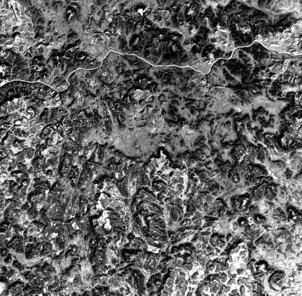
| Figure 3-1.
Landforms developed by erosion of Permo-Triassic rocks capped by basaltic trap.
Area shown in this Landsat image (1097-04465-5;Oct 28, 1972) is part of the
western Siberian Platform drained by the Nizhnyaya Tunguska river. Many hills
are flat-topped, reflecting control by the resistant volcanic members. The
Platform contains 750000 km2 of Mesozoic flood basalts. |
 |
|---|
Most (about 82 percent) currently active centers of
volcanism are concentrated on or near convergent margins
of continents and island arcs along plate boundaries within
the Pacific Basin ("Ring of Fire"). Nearly
14 percent of the world's active volcanoes are located in the
Indonesian Archipelago. Another 6 percent lie along the
Mid-Atlantic Ridge. Africa, the Mediterranean, and
Arabian Peninsula regions account for 5 percent. The
remainder occur at other plate boundaries within the ocean
basins (e.g., Hawaiian Islands) or continental interiors
(e.g., Yellowstone), generally where one or more subcrustal
thermal plumes (hot spots) have been identified or postulated.
Although the subaerial distributions of volcanoes now and in
the past are intermittent in time and space, the ocean basins
have experienced continuous buildup of volcanic layers since
at least the Triassic (and probably much farther back in time).
Where not covered by thin sedimentary deposits, the topography
of the ocean floor is distinctly that of a basaltic volcanic terrain,
with shield volcanoes, ridges, cones, and rifts adding variety to
an otherwise rather even low-relief surface.
Most landforms identified as specifically resulting
from volcanic action differ in two essential respects from
some of the other landform types treated in this book. First,
volcanoes and their derivative surroundings are primarily
constructional during their active or formative stages. Second,
most smaller volcanic landforms tend to develop to their full
extent more rapidly than many fluvial, tectonic, and other
landforms. The net effect due to this and to the high levels
of volcanic activity in the last few million years is that large
parts of a terrain dominated by volcanism appear to be notably
fresher or younger than terrain of a different nature, including
those adjacent to the volcanic field. In his textbook on
geomorphology, Von Engeln (1942) states:
"Volcanic force is endogenic and, as such,
gives rise to constructional landforms. These may be so
large as to constitute geomorphic units of first importance. . . .
The lesser volcanic features may be so numerous as to give
a distinct topographic aspect to wide districts (volcanic regions)."
In terms of the traditional (but now obsolete) Davisian
sequence of erosional stages from youth through old age,
many volcanic forms seem to be young as now observed.
While active, volcanoes are usually built up (repaired) faster
than destructional forces can reduce them because of
replenishment of surface cover by periodic (and often
spasmodic) outpouring of materials. Between occasional
eruptions, smaller volcanoes covered with ash undergo
conspicuous erosion in a matter of years. However, most
volcanic forms do not progress into maturity until the
activity causing them has either ceased or been long dormant.
For some, this may happen catastrophically, as when parts
of a structure collapse or are blown asunder during caldera
formation. Likewise, flows generally do not experience
significant weathering or removal until after the last flows
or ejects have covered them. Surficial forms and features
generated by tephra deposits are commonly short-
lived because of their ready erodibility. Volcanic structures attain
old age when much of their external protective covering has been
stripped off, leaving a core of more resistant rock.
Volcanoes develop from extrusion or expulsion of fluids,
congealed fragments, and gases that collect or distribute at or
near the Earth's surface to produce a variety of forms, chief of
which are conical, often mountain-like structures, thin to
thick piles of flow sequences, and sheets of airfall deposits of
tephra (fragmented particles of volcanic material). The forms
are controlled in part by the mode or types of volcanic activity.
This ranges from quiet emission to explosive ejection, depending
mainly on the gas content and viscosity (related to composition)
of the initial magma and resultant lava. The various modes of
eruption are identified by reference to an individual named volcano,
a regional location, or (in one case) a person (Pliny) associated with
the type of activity, as summarized in Table 3-1.
Table 3-1
Types of Volcanic Eruptions*
| Type |
Characteristics |
|---|
| 1. Icelandic |
Fissure eruptions, releasing free-flowing (fluidal) basaltic magma;
quiet, gas-poor- great volumes of lava issued, flowing as sheets
over large areas to build up plateaus (Columbia). |
| 2. Hawaiian |
Fissure, caldera, and pit crater eruptions; mobile lavas, with some
gas; quiet to moderately active eruptions; occasional rapid emission
of gas-charged lava produces fire fountains; only minor amounts
of ash; builds up lava domes. |
| 3. Strombolian |
Stratocones (summit craters): moderate, rhythmic to nearly
continuous explosions, resulting from spasmodic gas escape; clots
of lava ejected, producing bombs and scoria; periodic more intense
activity with outpouring of lava; light-colored clouds (mostly
steam) reach upward only to moderate heights. |
| 4. Vulcanian |
Stratocones, (central vents); associated lavas more viscous;
lavas crust over in vent between eruptions, allowing gas buildup below
surface; eruptions increase in violence over longer periods of quiet
until lava crust is broken up, clearing vent, ejecting bombs, pumice and
ash;
lava flows from top of flank after main explosive eruption; dark
ash-laden
clouds, convoluted, cauliflower-shaped, rise to moderate heights more of less
vertically, depositing tephra along flanks of volcano. (Note:
ultravulcanian
eruption has similar characteristic but results when other types (e.g.,Hawaiian)
become phreatic and produce large steam clouds, carrying fragmental
matter.) |
| 5. Vesuvian |
More Paroxysmal then Strombolian or Vulcanian types; extremely
violent expulsion of gas-charged magma from stratocone vent;
eruption occurs after long interval of quiescence of mild activity; vent
tends to be emptied to considerable depth; lava ejects in explosive spray
(glow above vent), repeated clouds (cauliflower) that reach great heights and
deposit tephra. |
| 6. Plinian |
More violent form of Vesuvian eruption; last major phase is
uprush of gas that carries cloud rapidly upward in vertical column for miles;
narrow at base but expands outward at upper elevations; cloud generally
low in tephra. |
| 7. Peléan |
Results from high-viscosity lavas; delayed explosiveness;
conduit of stratovolcano usually blocked by dome or plug; gas (some lava)
escapes from lateral (flank) opening or by destruction or uplift of plug;
gas, ash, and blocks move downslope in one or more blasts as nuées ardentes
or glowing avalanches, producing directed deposits. |
| 8. Katmaian |
Variant of a Peléan eruption characterized by massive outpouring of
fluidized ashflows; accompanied by widespread explosive tephra;
ignimbrites are common end products, also hot springs and fumaroles.
|
* Abstracted and modified from Chapter XII (pp. 305-31-) of Principles
of Physical Geology by A. Holmes, 2nd ed., Ronald Press, 1965, with
additional data from Volcanoes: In History, In theory, In Eruption, by
F.M. Bullard, University of Texas Press, 1962.
Classifications of volcanic landforms are surprisingly sparse
in the literature. Although textbooks and source books (at least
those in English) on volcanology (Rittman, 1962; Oilier,
1969; Macdonald, 1972; Bullard, 1976; Williams
and McBirney, 1978; Simkin et al., 1981)
concentrate on mechanisms of eruption and the petrology of products,
they describe most of the large and small scale structures and surface
phenomena attendant to the volcanism. More recently, Williams et al.
(1983) have developed a geomorphic classification of Icelandic
volcanoes. Bloom (1978) treats volcanic landforms in a separate
chapter early in his text book on geomorphology. He points out that
volcanism can be treated naturally from two viewpoints, either
petrologically (including mechanisms of emplacement) or as a
landform builder. He notes that classifications are based on one
or more defining parameters: (1) chemical composition (and
temperatures) of volcanic effluents, (2) state of the ejects released,
(3) history of the volcanic field, (4) shapes/locations of the
vents/fissures, (5) nature of the volcanic activity, and (6)
characteristic landforms. Bloom erects a classification around two
parameters: (1) viscosity (quality of magma) and (2) size of
the landform edifices (quantity of magma), yielding the types
shown in Table 3.2
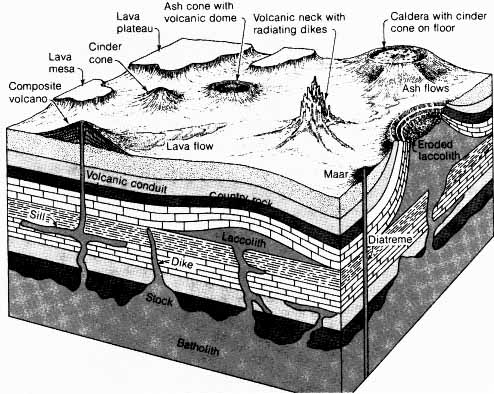
Many of these types are expressed pictorially in relation to their plutonic
sources in Figure 3.2
Table 3-2
Classification of
Volcanic Landforms* |
|---|
 |
*Adapted from Bloom (1978), as simplified from Rittmann *1962), Tables 4 and
5.
- Two other books place their prime emphasis on the volcanic
landforms per se. These are:
- C. A. Cotton, Volcanoes as Landscape Forms,
416 pp., Whitcombe and Tombs, Ltd., Christchurch, New Zealand, 1952.
- J. Green and N. M. Short, Volcanic Landforms
and Surface Features; A Photographic Atlas, 519 pp.,
Springer-Verlag, New York, 1971.
Cotton's book delves at length into development of volcanic
landforms by both petrogenic mechanisms and modifying
geomorphic processes. Numerous worldwide examples are given,
but an inordinate number come from his home country of New
Zealand. The Green and Short volume is primarily a pictorial atlas
with descriptive captions, but an introductory chapter by Arie
Poldervaart succinctly summarizes volcanic landform origin and
history from the dual standpoints of emplacement and erosion
processes.
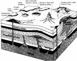 |
Figure 3-2.Schematic diagram showing
characteristic landforms resulting from volcanic action at the surface and their
relation to shallow intrusive activity in the crust (in Press and Siever (1982);
adapted from R.G.Schimdt and H.R. Shaw, U.S. Geological
Survey). |
|---|
In his book, Cotton proposes grouping volcanic landforms
into two first-order classifications, based on: A. Lava
Types = 1. Rhyolitic, 2. Andesitic, 3. Basaltic Landforms1
B. Fundamental Physiographic Types = 1. Mountains,
2. Plateaus, 3. Plains, as constructed by volcanic materials.
However, Cotton does not formally organize the many landforms
treated in his book into any specific classification. The author of
this chapter has developed a classification of sorts extracted from
the chapter and heading sections and some textual descriptions in
Cotton's definitive work. The result violates to some extent
principles of scientific taxonomy in that these headings are of mixed
character; certain ones refer to structures, others to topographic
features, and still others to phenomena or processes accompanying
eruption. Nevertheless, the classification as it appears in
Table 3.3 (with several
modifications from Green and Short) is valuable as a listing of most
common larger surface features attributable to volcanism. The table
also lists examples of each landform category from selected localities
and singles out those landforms (indicated by + ) known to be
visible from space. (Others on the list, some now being discriminable
but not clearly identifiable, maybe added as higher resolution stereo
sensors provide improved imagery.) Some volcanic landforms
exemplified in the space images are so large that they can be easily
seen, others nevertheless visible are much smaller (best seen under
magnification), and many occupy only a tiny fraction of the scene.
Table 3.3
Volcanic Forms and Features
| Types of Surface Features |
Selected Examples |
|---|
| Domes and Cones of Basaltic Lava |
|
Basalt Cones +
Central and Fissure Vents
Flank Outflows of Lava +
Basaltic Lava Shield (small) +
Basalt Dome (shield) Structure +
Icelandic Spatter Cones
Scoria Cones |
San Francisco Volcanic Field, Arizona
Haleakala, Hawaii
Mauna Loa, Etna
Skjaldbreidur, Iceland
Mauna Loa; Mauna Kea
Búrfell, Iceland
Búdaklettur, Iceland |
| Lava Plateaus and Plains |
|
Ignimbrite Plateaus +
Basalt Plateaus +
Fissure Eruptions +
Phonolite Plains +
Basalt Plains + |
New Zealand; Yellowstone; New Mexico
Deccan, India; Columbia, NW U.S.; Drakensburg, South Africa
Lakigígar, Iceland
Kenya; Dunedin; New Zealand
Snake River, Idaho |
| Lava Fields |
|
Lava Tongues +
Ponded Lavas
Pahoehoe: Tumulis; Squeeze-Ups; Pressure Ridges
Block Pahoehoe
Block aa
Block and Ashflows
Fire Fountains
Scoria Mounds (cinder cones)
Adventive Cones |
Galapagos, Ecuador
Keanakakoi, Hawaii
Many
McCartys Flow, New Mexico
Mt. Vesuvius, Italy
Martinique; Merapi, Java
Hawaii
Stromboli, Italy; Teahuahua, New Zealand
Mauna Kea, Hawaii |
| Exposed Intrusive Features |
|
Laccoliths +
Dikes, Sills + |
Henry Mountains, Utah
Spanish Peaks, Colorado; others |
| Maars and Tuff Rings |
|
Maars +
Ubehebes
Basaltic Tuff rings +
Diatremes + |
Eifel, France; Lago di Nemi, Italy
Death Valley, California
Diamond Head, Hawaii; Mt. Gambier, Australia; Hverfjall, Iceland
Hopi Buttes, Arizona; Kimberlites, South Africa |
| Rifts | |
Rift Valley +
Rift Liners + |
Africa
MÝvatn Area, Iceland; Tarawera, New Zealand |
| Craters and Calderas |
|
Craters +
Pit Craters
Calderas +
Glencoe
Krakatoa
Multiple
Erosion Calderas +
|
Mt. Ubinas, Peru
Nyirangongo, Kenya; Halemaumau, Hawaii
Mt. Vesuvius, Italy; Fernandina; Aso, Japan
Krakatoa, Indonesia; Aniakchak, Alaska
Dyngjufjöll, Iceland
La Palma, Canary Islands; Mauritius; Banks Peninsula, New Zealand |
| Viscid Lavas, Coulées, and Tholoids |
|
Convex Lava Flows
Cumulo Domes (Tholoids)
Obsidian Domes
Plug Domes
Spines |
Ascension Island, United Kingdom; Mono Craters,
California
Mayor Island, New Zealand; Puy de Dome, France; Tarawera, New
Zealand
Mono Craters, California
Usu, Japan; Lassen Peak, California
Mt Pelée, Martinique |
| Tephra Showers and Nuées Ardentes |
|
Vulcanian Ash Phase
Nuées Ardentes (First Orders) +:
Plateau-Building (Ignimbrite Sheets) +
Nuées Ardentes (Second Order) |
Mt. Vesuvius, Italy1 Taupo, New Zealand; Katmai,
Alaska
Mt. Pelée, Martinique; Valley of 10000 Smokes, Alaska
Bishop Tuff, California; Yellowstone Park, Wyoming-Montana
Mt. Pelée, Martinique; Santa Maria |
| Tephra-Built Stratified (with lava) Cones |
|
Ash Cones +
Young Cones
Composite (stratified)Cones +
Multiple Cones +
Parasol Ribbing
Lahars (mudflows) + |
Fujiyama, Japan
Vulcan, Italy; Rabaul, Papua, New Guinea; Paracutín, Mexico
Merapi, Indonesia; Mayon, Philippines; Agua, Guatemala
Tongariro, New Zealand
Mt. Vesuvius, Italy; Paracutín, Mexico
Bandaisan; Balunggung, Indonesia |
| Erosion Features |
|
Ravine Cuts (Barrancos) +
Planeze Stage of Dessection +
Necks and Plugs +
Erosion Caldera +
Eroded Dome
Lava Ridges (inverted Topography) +
Lava Palisades |
Popocatepetl, Mexico
Cantal, France
Shiprock, New Mexico; Roche St. Michel, France; Hopi buttes, Arizona
Huahine, Society Islands
Haleakala, Hawaii
Australia
Hudson River, New York |
Some specific types mentioned in Tables 3-2 and 3-3 deserve
further comment. Domical volcanic landforms (exogenous domes)
result from the comparatively high fluidity of basaltic magmas.
Smaller dome-shaped mountains, of the Icelandic type, have
gentle lower slopes that may increase to angles of 20° or more
toward the top. The much larger Hawaiian type (Plate V-10) has
slopes around 1 to 3°, rarely exceeding 10°. Individual edifices
may have basal dimensions approaching 100 km on a side and
heights of 3 to 5 km. (The island of Hawaii is 400 km in diameter
at its submarine base and reaches a total height of 10 km.)
Flood basalt plateaus and plains (Plates V-5, V-7, V-20, and V-23)
cover areas exceeding 10000 km2. While generally of low relief after
the final eruptive emplacement of lava onto a thickening pile, the terrain
is affected by later erosion that produces notable relief characterized by
benches and cliffs. This landscape form is sometimes referred to as
"treppen" (step-like).
Composite volcanoes or stratocones comprise one of the most
distinctive of all landforms. They occur in isolation (Mt. Etna,
Plate V-16), in alignments (Kamchatka, Plate V-25), or in clusters,
often numbering more than 100 in a field (Andes, Plate V-14).
Stratocones may begin as tephra rings and grow into larger bodies
(typically circular in plan view by repeated periodic episodes of
eruption of both tephra (ash, lapilli, and blocks) and lavas. These
two types of effluents complement each other in building up a stable
structure. Outpourings of lava mix with fragmental ejecta to construct
a reinforced conical landform about a structural mainframe consisting
of dikes, sills, and cone sheets. The main, usually central vent, often
topped by a crater at the surface, may also contain one or more
endogenous domes (Plate V-8), also known as tholoids, or may extrude
a transient spine of congealed lava.
Many larger stratocones eventually self-destruct by some type
of explosive eruption, often resulting from introduced sea or ground
water or melted snow, that succeeds in blowing away the peak and parts
of the framework (Plate V-24). Expulsion of great volumes of ejecta
and/or withdrawal of melted rock from the proximate magma
chamber commonly robs the upper structure of support, leading to
collapse and, at times, additional explosive ejection of the fragmented
materials. The large craters (>1 km in diameter, up to 10 km or more)
are termed calderas; if the rim of this great cavity remains intact, the
caldera may fill with water to form a crater lake (Plates V-6 and V-18).
Ignimbrites
expelled during these events may spread over wide areas, as at the
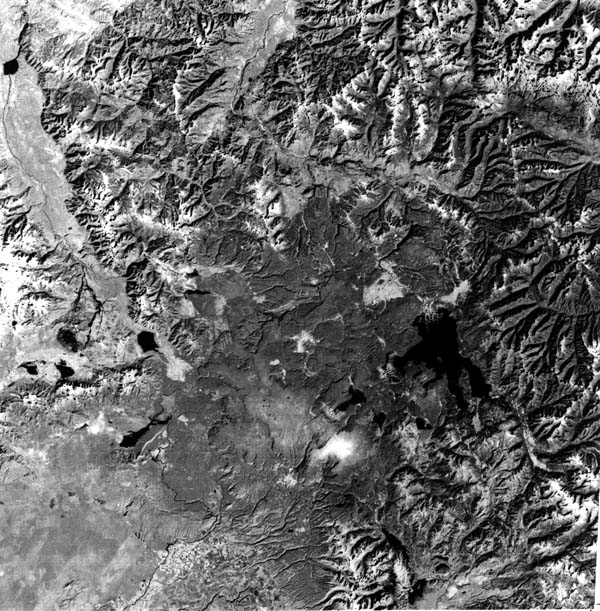
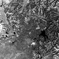
Yellowstone region in Wyoming (Figure 3.3), infilling more
rugged terrain to produce an aggradational plateau.
| Figure 3.3.
Mountainous and flatlands terrain developed on ignimbrites, flows, and ash
deposits produced during Late Tertiary and Quaternary volcanic activity in and
around present-day Yellowstone National Park in northwestern Wyoming (landsat
1825-17294-7; October 26, 1972). |
 |
|---|
A few added comments concerning the relevant volcanic features
that can be recognized in the space images (those taken both from
satellites and by astronaut-operated equipment) shown in this
chapter closes the introductory section:
- For the most part, the scenes are mainly a mix of volcanic
and other types of landforms. Plate V-4, for example, shows the
Pinacate Field in northernmost Mexico as an area of recently active
volcanism set apart from the Basin and Range structural landforms
that dominate the scene. By contrast, the entire image of the Afar in
Ethiopia (Plate V-21) depicts a volcanic terrain exclusively.
- The most common associations with volcanic landforms are
those of tectonic/orogenic origin. This is to be expected in as
much as anorogenic volcanism is the exception even on the continents.
Volcanism is a characteristic or hallmark of several tectonic regimes.
Referring to the classification given in the introduction to Chapter 2,
Tectonic Landforms (p. 30), one can predict volcanic activity
concomitant with lithospheric plate interactions for the following
classes (named and then listed by the number-letter code used in
that classification):
I.Divergent Plate Margin:
- a. Intracontinental Rift (A-1)
- b. Oceanic Spreading Center (A-2)
II. Convergent Plate Margin:
- a. Ocean-Ocean Plate Margin (B-1)
- b. Ocean-Continent Margin (B-2)
- c. Continent-Continent Margin (B-3)
III.Transform Zone:
- a. Trench-Trench (Dead Sea Type) (C-1)
- b. Ridge-Trench (San Andreas Type) (C-2)
- c. Ridge-Ridge (San Andreas Type) (C-3)
IV.Plate Interior:
- a. Shields (D-1)
- b. Posttectonic Magmatic Intrusions (D-4)
- c. Hot Spot Track (D-7)
- Space imagery is especially effective in placing active, recent,
or older, but nearly always Cenozoic, volcanism in context with
several types of structural control. Fault zones and rifts are the
prevalent types, as exemplified in Plates V-21, V-25, and V-27.
Alignments of volcanoes are frequently obvious, but the controlling
fracture sets and lineaments are more difficult to discern in many images.
- Recognition and better definition of many volcanic land-forms
that stand above their surroundings (cones, domes, eroded dikes,
and viscous flows) are significantly enhanced by winter imagery (see
Plates V-2 and V-25), owing to both lower Sun angles and occasional
snow cover.
- Again, the synoptic aspect of space imagery helps to call
attention to the remarkable range in sizes among such volcanic
structures as stratocones (compare Plates V-14 and V-17)
and calderas (Plates V-13 and V-18).
- Some landforms that at least partially owe their existence to
volcanism display only subtle evidence of this connection in the
imagery. The rounded hills and sculptured divides seen in
Figure 3-1 do not readily
manifest the influence of basaltic trap flows that cap underlying
sedimentary rocks in the Siberian Platform, nor do the Karoo dolerite
sills of South Africa (Plate V-20) produce a landscape that makes
evident the role these intrusions play in the landform pattern.
- Other volcanic landforms maybe obscured by land-use
patterns or soil cover. This is evident in the Deccan Plateau of India
(Plate V-23) and the Snake River Plains of Idaho (Plate V-6).
Tephra deposits are geologically transient, as indicated in the Mt. St.
Helens subimage (Plate V-8), where only a few years of forest
growth has diminished the once sharp contrast between tephra deposits
and vegetated terrain.
- As is evident in Table 3.3,
space imagery is presently not well suited to recognizing the majority
of volcanic features whose critical dimensions are less than the effective
resolution of the sensor system. This group of phenomena include
pahoehoe, blocky, and aa lavas, plug domes, tholoids. spatter cones,
hornitos, pit craters, many dikes (and dike swarms), and nearly all other
small features. Some of these are even difficult to locate and identify in
aerial photos. Certain other smaller features-maars, diatremes, necks,
lahars, and welded tuff units--can frequently be spotted in space images
of adequate resolution.
- Finally, under fortuitous circumstances, space imagery can
capture a volcanic eruption "in the act" or can often
provide the first direct evidence of the consequences of that eruption
shortly thereafter. Plate V-8 offers a dramatic example in its
extended coverage of the 1980 eruptions at Mt. St. Helens, during
which a NOAA satellite actually picked up the airborne ash clouds in
transit and after which Landsat provided the first complete view of
the devastated area around the volcano. A lava flow in process of
descending from one of the Galapagos volcanoes is visible in
Plate V-13. New flows from eruptions at Mt. Etna (Plate V-16)
in the 1980s are readily discernible.
Continue to Plate V-1|
Chapter 3 Table of
Contents.|
Return to Home Page|
Complete Table of Contents