 |
 |
|---|---|
| Plate V-12 | Map |
|
|
|---|---|
| Plate V-12 | Map |
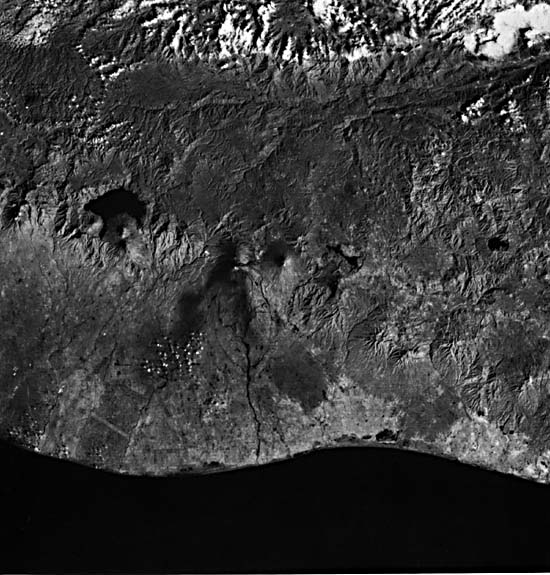
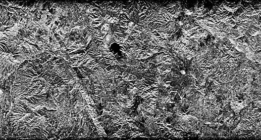
This image and the SIR-A Radar strip (Figure V-12.1) that traverses its eastern side are of volcanoes along the so-called Andesite Line that parallels the Pacific Basin. Here in southern Guatemala, a country roughly the size of Ohio, the small Cocos Plate east of the East Pacific Rise is subducted under a regional sliver of the Caribbean Plate (Nagle et al., 1977). The zone of subduction lies offshore approximately coincident with the Middle America Trench. Onshore, a eugeosynclinal belt (A) of Paleozoic sedimentary rocks (mainly graywackes) has been metamorphosed (upper greenschist facies) to slates and phyllites, accompanied by diabase and basalt. The grade increases to produce schists, gneisses, and amphibolites farther north (B). Granitic to dioritic plutons dated from 345 Ma ago (Pennsylvanian) through Cretaceous intrude this complex at several places (C). A major shear zone, the Motagua Fault (D), cuts across these older exposures of the Caribbean plate; its surface expression is a deep valley that localizes the Rio Motagua. Strong deformation during the Late Cretaceous to the Eocene imposes an east-west grain on this crystalline basement (Guatemala Massif) in the Central Guatemala Cordillera which, in this region, is an extension of the Cayman Trough traceable across much of the western Caribbean. Metasediments give way to folded sedimentary units along the northern boundary. To the north, this boundary (just off the scene) is the Polochic fault zone, a left lateral system that separates the Caribbean and North American plates. There and northward into the Petén Basin, the rocks comprise gently folded Cretaceous carbonates and Tertiary elastic and evaporite deposits.
| Figure V-12.1 |
|---|
 |
Extensive volcanism began in the Tertiary along fracture zones associated with a structural trough or graben (Bonis, 1967). Activity in the Miocene consisted of fissure-type eruptions predominantly of rhyodacitic composition that covered the older basement. These, together with ignimbritic units, volcano-clastic units, and laharic deposits, comprise a broad belt (E) that occupies the southern margin of the Cordillera (Williams and McBirney, 1964). By the Quaternary, volcanic style had shifted to buildup of large composite stratocones that straddle the south side of the earlier volcanic belt. Most of these lie between 2600 and 4210 m in elevation. The volcanoes expel primarily pyroxene andesites as ash, ignimbrites, and other pyroclastic material that concentrated to the south (F), along with dacitic pumice that collected northward in lower areas (G) owing to prevailing offshore winds. Rhyolitic obsidian in domes and basaltic cinders and flows around cinder cones also were emplaced at this time.
| Figure V-12.2 |
|---|
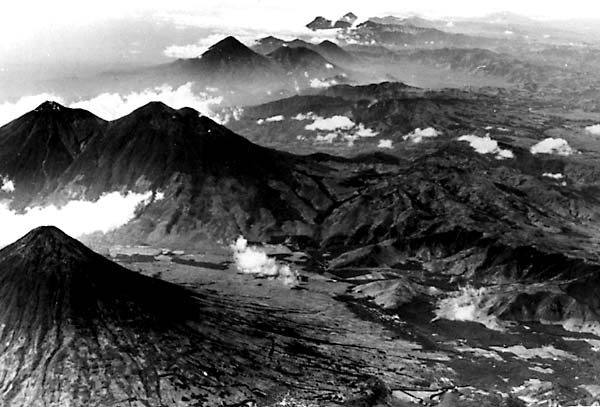 |
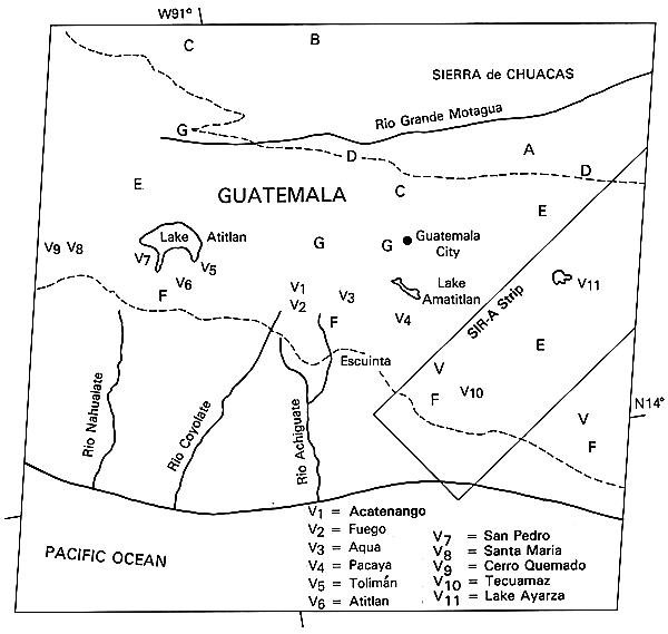
A major caldera formed earlier is now occupied by Lake Atitlan. A smaller subsidence structure has localized Lake Ayarza (V11). Explosive volcanoes distribute in several clusters (Figure V-12.2) controlled first by northwest trend of the trough and also by north-south cross faults. Holocene eruptions have been observed at Volcano Santa Maria (V8; 1902, 1922, 1969), Cerro Quemado (V9; 1783), Atitlan (V6; 1856?), Acatenango (V1; 1926-27), Fuego (V2; 1971), and Pacaya (V4; 1970) (Macdonald, 1972). The Santa Maria event (which actually took place from a subsidiary domal vent named Santiaguito) included release of a nuées ardentes, as well as lava flows and lahars. Other volcanoes, such as Agua (V3), Tolimán (V5), San Pedro (V7), and Tecuamaz (V10), have not been active since the Spanish Conquest.
The Pacific Coastal Plain Province, up to 70 km wide, is constructed largely from detritus carried in by the debris-choked streams coming off the Volcanic Highlands Province. Sands and gravels, mixed with pumiceous ash and extensive laharic deposits, form coalescing alluvial fans. Much of the population of Guatemala lives on this plain, which hosts most of the agricultural production. Additional Reference: Sapper (1925). Landsat 21449-15304-7, January 10, 1979.
Continue to Plate V-13| Chapter 3 Table of Contents.| Return to Home Page| Complete Table of Contents