 |
 |
|---|---|
| Plate V-19 | Map |
|
|
|---|---|
| Plate V-19 | Map |
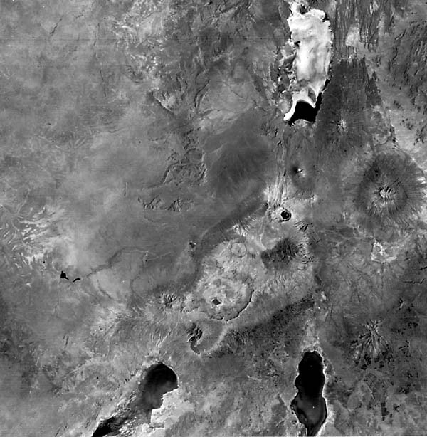
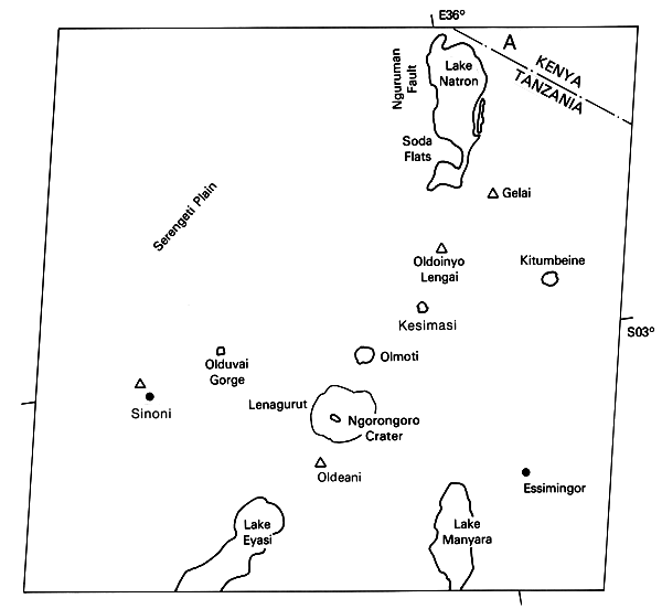
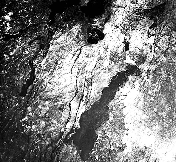
This scene lies almost entirely within the north-central section of Tanzania. The central part of the image is athwart the southern extension of the east or Gregory arm of the Great Rift Valley described in detail in Plate T-35 (Baker et al., 1978). Surficial evidence of rifting is less conspicuous in this segment than farther to the north, except for occasional step-fault traces (A) (Figure V-19.1) and the north-south elongation of the three lakes shown. In this part of East Africa, the rift has split into an Eastern (shown here) and a Western Rift owing to deflection of the main fracture system by the Tanganyika craton (Fiarhead, 1980). In the image, the Eastern Rift south of the Nguruman Fault has further split into two segments that pass by the elongate shores of Lake Manyara and Eyasi. The rift farther south becomes less well defined as it intersects on a southwest- trending structural lineament reaching almost from the Indian Ocean down to Lake Malawi, where it joins the Western Rift. Rifting in East Africa is associated with uparching of the Kenya Arch. Directions followed by most rift fractures appear to be closely controlled by lineaments in the underlying Precambrian. The eastern side of the Eastern Rift is a step-faulted downwarp; sharper faults line the western side. Although large throws (1000 to 3000 m) have been measured, the present topography is held to elevations around ~600 to 900 m, and relief is subdued.
The western third and isolated sections elsewhere in this image are part of the Serengeti Plain, underlain mainly by Pre- Cambrian crystalline and metasedimentary rocks. This plain is a remnant of an Early Cenozoic erosion surface. Drainage presently moves westward toward Lake Victoria and the Western Rift, with the divide near the east side of the image. Lateritic soils have developed over these and younger volcanic rocks. The shallow lakes of the region are examples of interior drainage in which water levels fluctuate considerably and salts are concentrated by evaporation. Lake Natron, for example, contains thick deposits of sodium carbonate.
| Figure V-19.1 | Figure V-19.2 |
|---|---|
 |
 |
Volcanism began in the Tertiary and continues even now (Goles, 1980). Many volcanoes are found within the rift zone, but it is often difficult to associate a given volcano with individual faults. Several of the volcanoes, however, lie outside the primary zone of rifting (e.g., the space view of Mt. Kenya (Figure V-19.2) and Mt. Kilimanjaro elsewhere to the east off image). Inception of the first significant volcanism roughly coincided with the start of major rifting in the Miocene (Baker and Wohlenberg, 1971). Volcanic outpourings nearly fill most of the rift depressions and, in this scene, spill beyond westward and for 150 km to the east. Two series of compositional trends are distinguished: one is notably alkaline, is marked by nepheline, and evolves into phonolites; the other is less alkaline and nepheline-free, with rhyolites and trachyandesites as end products. Basalts and nephelinites emerged first, some from central volcanoes. Vast floods of phonolite followed, building up a plateau of flow units that extends beyond the main zone of rifting (Goles, 1980). A succession of trachytes, nephelinites, and phonolites, then more basalts, and finally trachytic pyroclastic units closed out the Tertiary activity. Quaternary volcanism began with fissure eruptions of basalt and basanite lavas, and then trachytes, rhyolites, and phonolites erupted from central vent volcanic edifices located within late-forming grabens of the rift zone.
A cluster of peaks and calderas dots the aptly named Crater Highlands northeast of Lake Eyasi. Dominant among them is the shallow caldera of Ngorongoro, with its satellites, Oldeani and Lemagarut, and the smaller crater of Olmoti. These now extinct volcanoes erupted trachytic flows and large quantities of pyroclastic materials that in places are recognized by their lighter tones. Tephra from these sources play a role in geochronology at Olduvai Gorge, where skeletal remains of early hominids are preserved.
| Figure V-19.3 |
|---|
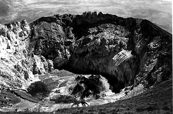 |
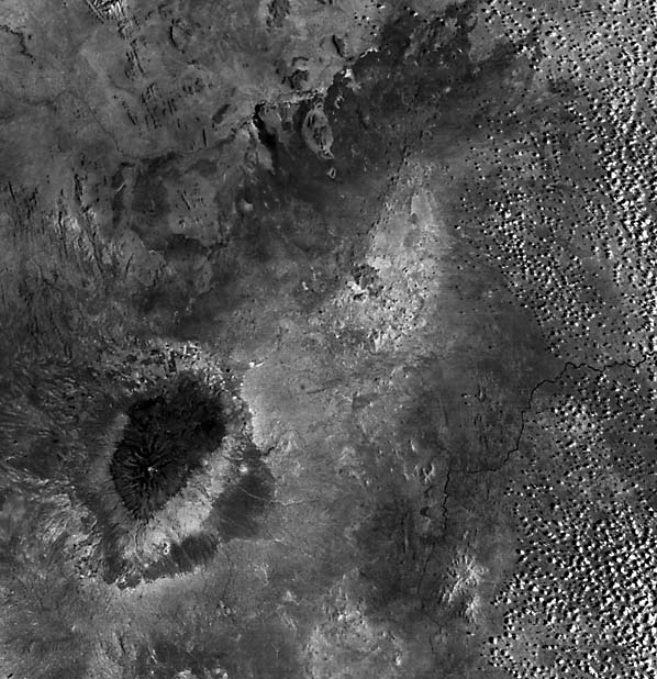
Volcanoes Essimingor and Gelai follow the nephelinite/ phonolite trend. That small conical volcano, Oldoinyo Lengai (2880 m above sea level; Figure V-19.3), and the nearby caldera-topped Kerimasi have expelled ash of carbonatite composition and sodium-rich flow material is well known from Oldoinyo (note bright spot in its interior). This is the only active volcano in this region of the rift, having erupted more than eight times in the last 300 years. These volcanoes are the principal suppliers of the soda that accumulates in the Lake Natron lacustrine deposits. Kitumbeine to the southeast is a smaller version of Mt. Kenya and is the source of phonolite and basalt flows and ash (LeBas, 1977). Text modified from comments by G. Goles, University of Oregon. Landsat 2368-07040 -6, January 25, 1976.
Continue to Plate V-20| Chapter 3 Table of Contents.| Return to Home Page| Complete Table of Contents