 |
 |
|---|---|
| Plate V-25 | Map |
|
|
|---|---|
| Plate V-25 | Map |
The Kamchatka Peninsula in eastern Siberia is a segment of the famed Pacific Ring of Fire. Together with Java, it ranks as one of the most active volcanic segments along the ring, and one of its volcanoes, Klyuchevskaya, is claimed to be the most active in the world (Markhinin, 1971). The peninsula is approximately 1200 km (750 miles) long and varies in width from 485 km (300 miles) to a minimum of 97 km (60 miles). At its southern tip, it ties in with the Kurile Islands, another volcanic chain. Tectonically, this peninsula is akin to an island arc, analogous to those in Indonesia, except for its continuity with the Asian mainland. In some respects, its closest analog on the ring is the Cascade Range of western North America (Coster, 1963). The Kamchatka Peninsula connects with the great arc system of the Aleutian Islands at a juncture near latitude 58°, but the two arcs lie parallel to trenches that meet at nearly 90°, just offshore from the central part of the peninsula.
| Figure V-25.1 | Figure V-25.2 |
|---|---|
 |
 |
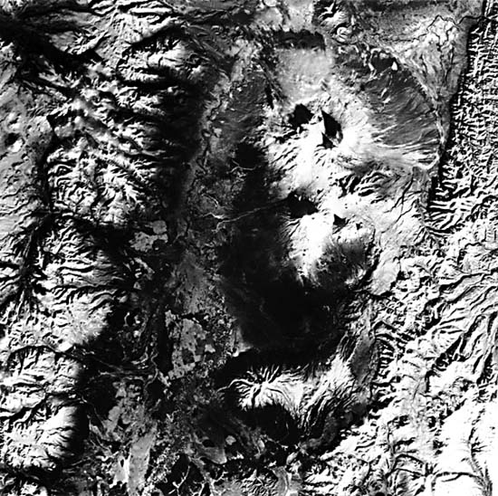
The backbone of Kamchatka is the Shredinny Khrebet, subdivided into the western and eastern ranges, composed of Mesozoic gneisses and granites, Cretaceous/Paleocene volcanics and clastic and siliceous sediments. Miocene tuffs, all strongly folded in the Pliocene, were followed by volcanic renewal through the Quaternary to the Holocene. Erlich (1979) describes the structure of Kamchatka as a geanticlinal- volcanic island arc belt that underwent abrupt uplift in the Quaternary, during which an en echelon system of anticlinal horsts and synclinal grabens developed; present volcanism is concentrated in these grabens, which as intermontane troughs have partly backfilled with alluvial deposits. More than 100 volcanic edifices are recognized on the peninsula, of which at least 15 comprise currently active vents. Most older volcanoes occupy the western half of the peninsula; by Quaternary time, the main belt of volcanoes had shifted to the eastern third. The eastern zone is structurally controlled by lineaments that parallel the northeast alignment of the ranges. A second lineament trend, northwest, approximately in the direction of the Aleutian Trench, also influences the distribution of some volcanoes. The majority of volcanoes are composite stratocones, some now topped by calderas built mostly of pyroxene andesite tephra mixed with some lava flows (Zavaritski, 1977).
| Figure V-25.3 |
|---|
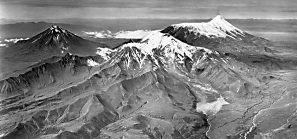 |
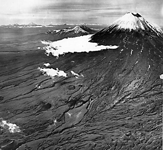
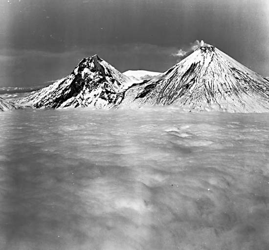
The main cluster (Klichii Group) of volcanoes seen in the Plate, dominated by Sopka (Volcano) Klyucheyskaya (A), 4850 m high, lie within the intersection of sets of northeast- northwest lineaments (Erlich et al., 1972). These volcanoes occur within a broad structural trench or graben through which flows the Kamchatka River and whose surface is 500 to 1500 m above sea level. The elegant profile of Klyucheyskaya (Figure V-25.1) attests to its continuing eruptions (more than 75 since 1700 A.D.; a major one in 1915), which add materials to its constructional surface faster than erosion can dissect it. Aligned with Klyucheyskaya along a northeast line are the nearby volcanoes, Bezmyanny (B) and Kamen (C) (4617 m) (Figure V- 25.2), Tolbachik (D) (active; 3682 m), Kharchinsky (E) and the breached crater of Zarechny (F), and the active Shiveluch (off the image just to the north); Shredinaya lies in the shadow of Klyucheyskaya. The inactive Ploskaya (G) (4030 m), with a prominent central caldera, and the Zimina group (H) (Figure V-25.3) form along a northwest trend. The Udina volcanoes (1) complete the cluster. To the south, Sopka Kinchkolak (J), also known as Gora Nikotka, has been much dissected into barrancos (consequent stream-cut ravines). In the uplands above the graben, in the Tumrot Range, stands the active Sopka Kizimen (K) (2375 m relief).
| Figure V-25.4 | Map V-25.2 |
|---|---|
 |
 |
Another major line (almost 400 km long) of volcanoes, the North Kamchatka/Olyutorsky Group, occupies a graben valley on the west side of the Shredinny Range. Near the left edge of the Plate is a cluster of these volcanoes, including a stratocone at X, that corresponds to a segment of the group including Eggela, Budul, Kapkan, and Anuan.
| Figure V-25.5 |
|---|
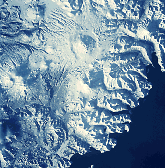 |
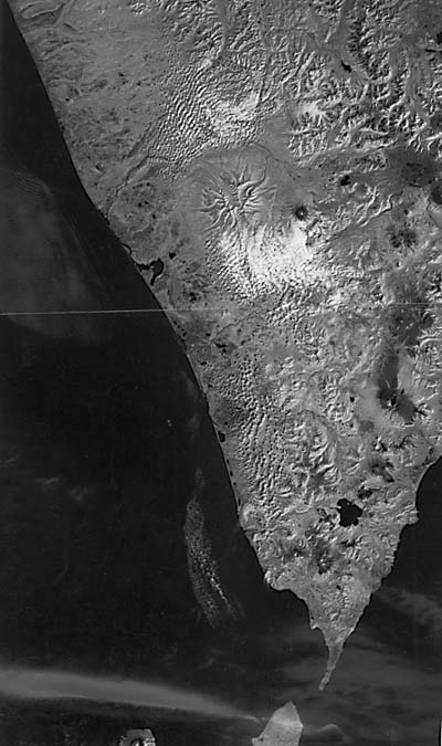
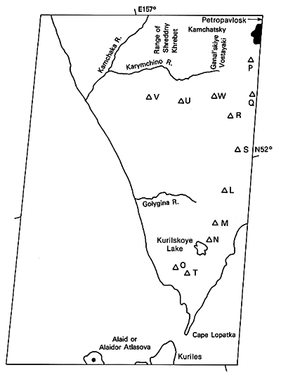
A joined pair of Landsat images (Figure V-25.4) depicts the southern end of the Kamchatka Peninsula. Here the locations of most volcanoes near the eastern side of the peninsula are clearly defined. Active volcanoes include Ksudach (L) (1095 m), Zheltovsky (M) (1953 m), Ilinsky (N) (1578 m), and Koshelev (0) (1863 m). Older sopkas are represented by Vilyuchik (P) (2175 m), Asacha (Q) (1137 m), Svetly (R), the Khodutka group (S), and Kambolnaya (T) (2160 m). Off the main trend are the still-active Opala (U) (2475 m), the huge strongly dissected Ipelka (V) (1911 m), and Tomalchev (W) volcanoes. Some Russian volcanologists consider Kurilskoye Lake to be a large collapsed caldera. Between Asacha and Vilyuchik, and just off the mosaic, is another group, shown in a photograph (Figure V-25.5) taken during the STS-9 (Shuttle) mission. The large caldera, with its tiny crater-capped central cone, is Gorely. To its south is Mutnovsky and to its east is Falshivy. Tomalchev appears once again near top left. Landsat 1477-23543-6, November 12, 1973.
Continue to Plate V-26| Chapter 3 Table of Contents.| Return to Home Page| Complete Table of Contents