 |
 |
|---|---|
| Plate F-17 | Map |
|
|
|---|---|
| Plate F-17 | Map |
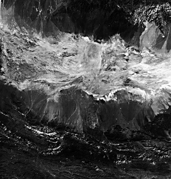
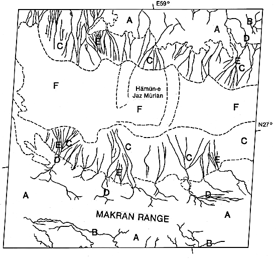
The rugged terrain of southeastern Iran is an extension of the Zagros Mountain ranges that parallel and are responsible for the eastern margin of the Persian Gulf (Plate T-41). This fold belt has ridges frequently exceeding 1500 m high that are arranged in a general northwest-southeast direction consistent with the long dimension of the Gulf. These ridges and the somewhat more complicated mountains of southeast Iran (see A on index map) are commonly anticlinal features that formed during the Pliocene/ Pleistocene Zagros orogeny. Throughout most of the Zagros Mountain trend, the linear topographic highs represent huge folds with steeply dipping flanks, the result of orogenic movements directed toward the Gulf. Many of these large anticlines contain hydrocarbons and form the foundation for Iran's petroleum reserves.
Across the Gulf from southeastern Iran are the Oman Mountains (Plate T-40), which developed during the Late Tertiary into the Recent as a large rugged range that sweeps around from a northwest-southeast orientation to a north-south trend as it approaches Iran at the Strait of Hormuz. The northern plunge of the range into southeast Iran is reflected in the complexity of the Iranian mountains of this region where the Zagros and Oman trends meet. In such a complicated mountainous region, numerous intermontane basins like the one shown in the Landsat scene are being filled by alluvial deposits derived from erosion of surrounding mountains. The process of basin-filling is to a large extent controlled by climate.
| Figure F-17.1 | Figure F-17.2 |
|---|---|
 |
 |
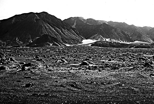
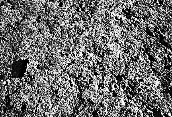
The region around the Persian Gulf is characterized by an arid climate with an average annual rainfall of about 5 cm for the Arabian side, whereas the mountains of Iran receive from 20 to 50 cm, which favors numerous small mountain streams (B) and small rivers. One aspect of this type of drainage system in an arid to semiarid climate is its sporadic discharge. High relief and a lack of organic material in the surface sediments favor rapid runoff or flash floods when rains occur. These violent events can transport boulder-sized particles down well-defined and steepsloping routes through the mountains to the basin. Alluvial fans (C) are the result of this sedimentation process (Figure F-17.1). The term "fan delta" is sometimes used when these coarse sediments are deposited in standing water of a lake or the sea. Regardless of the climatic setting, these features occur adjacent to areas of high relief (A), as is clearly visible on the image.
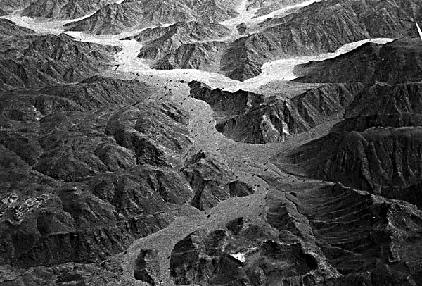
The typical shape of alluvial fans results mainly from increased frictional resistance as the relatively deep confined intermontane stream network (D) enters a basin, where the streams change to a braided system of shallow channels on the fan (E). Figure F-17.2 illustrates the stream beds that consist of coarse sediment, which are typical of arid and semiarid source areas where runoff tends to be an infrequent but violent event. Because of the high relief of source areas and the hydraulic characteristics, such as sporadic discharge, alluvial fans are commonly composed of coarse gravel and boulder-sized sediment near the mountain fronts. Grain size decreases rapidly downfan. In the Landsat scene, the dark proximal parts of the alluvial fans are the accumulation areas for gravel- and boulder-sized sediments. Figure F-17.1 shows very coarse debris associated with the proximal area of a small alluvial fan complex very much like some of the small fans of the Landsat scene. Note the small dunes that commonly form in association with arid alluvial fan complexes.
| Figure F-17.3 |
|---|
 |
Intermontane basins are commonly the sites of playa lakes and their sedimentary counterparts (F). In the Persian Gulf/Iranian mainland area, strong winds, arid to semiarid conditions, and seasonally high temperatures promote high rates of evaporation. These conditions induce the drying of lakes that develop as a product of the enclosed drainage system. In this process, the deposits of these playas are characterized by great lateral continuity of fine-grained sediments, little vegetation, desiccation cracks, and the occurrence of evaporite minerals. Environments of deposition that fit this description are sometimes referred to as continental sabkhas. Because alluvial fans (C) at the basin's edge trap most of the coarse sediment, deposits of the basin interior are generally fine- grained (terrigenous clay and silt) with carbonate and evaporite precipitates. Figure F-17.3 illustrates the surface of a continental sabkha covered with evaporite minerals (largely salt) and carbonates precipitated as the lake dried. The white areas in the Landsat scene are similar deposits in this arid intermontane basin of southeast Iran. Although most sediments that fill the central parts of these basins are fine-grained, occasionally large flash-flood events will deliver coarse sediments to the playa. Strong winds blowing across these arid regions also concentrate sand-sized sediment in the form of dunes that can migrate over the playa surface. (GCW; J. M. Coleman) Landsat 1127-06065-7, November 27, 1972.
Continue to Plate F-18| Chapter 4 Table of Contents.| Return to Home Page| Complete Table of Contents|