 |
 |
|---|---|
| Plate F-22 | Map |
|
|
|---|---|
| Plate F-22 | Map |
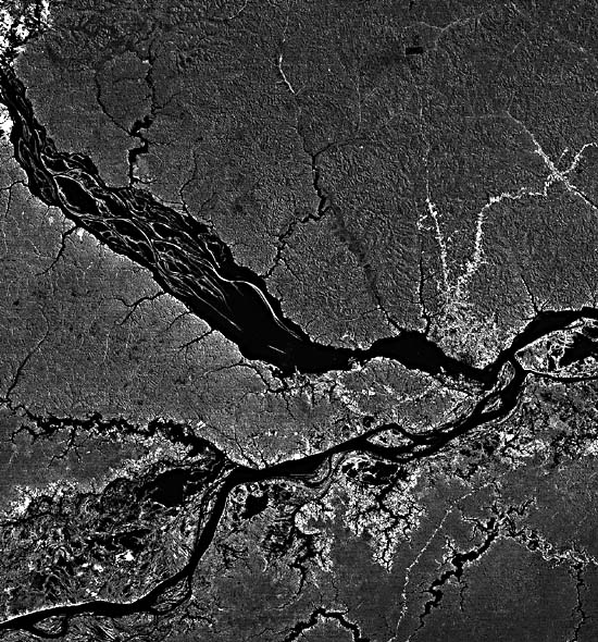
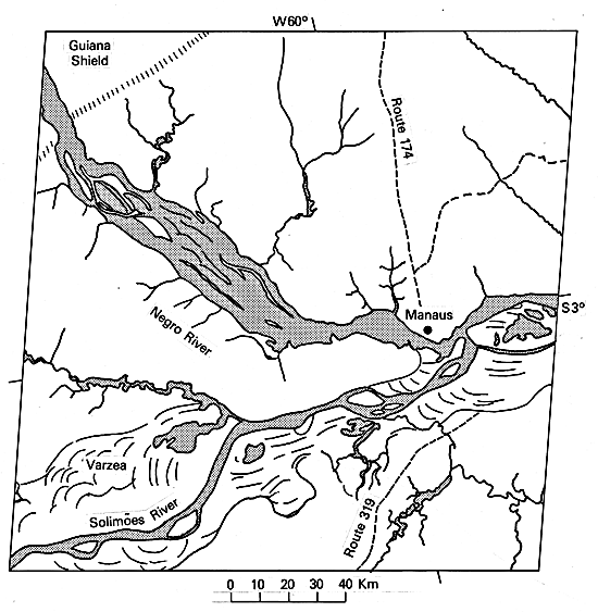
This scene shows the confluence of two of the world's largest rivers, the Rio Negro and the Solimões River, which join in the central Amazon basin to form the Amazon River ("Amazonas" in Brazil). The major city of this region, once called "Amazônia," is located at the confluence. Originally built as a colonial fort in 1669 by the Portuguese, the site evolved to the town of Manaus, with continual settlement since the 18th century.
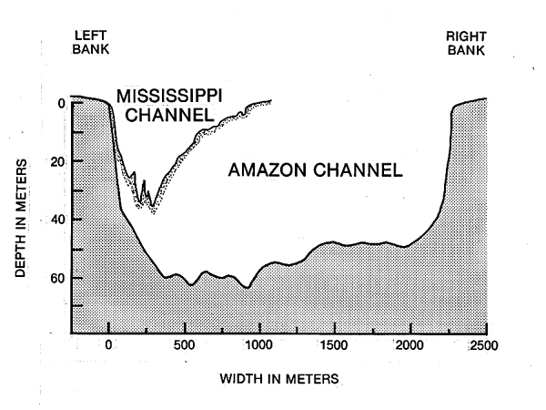
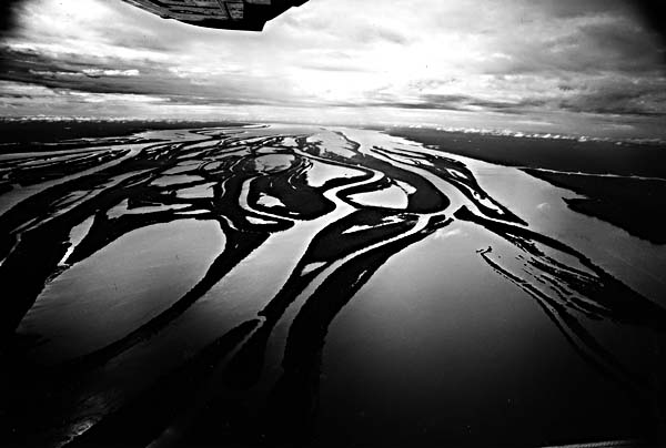
The Amazon is the world's largest river. At the Óbidos Narrows, 600 km east of Manaus, the river channel is over 2 km wide and 60 m deep. This cross section is compared to that of the Mississippi River at Vicksburg in Figure F-22.1. The river flow measured on June 5, 1972, was 255000 m3/s (9000000 cfs), the largest freshwater flow measured on Earth (Sternberg, 1975). Since several major tributaries enter downstream of Óbidos, it is clear that the Amazon experiences much larger flows. The 6300 km3 of water that it delivers to the ocean each year is approximately 15 percent of all fresh water passing from the continents to the oceans. Figure F-22.2 is a Landsat scene showing a large sediment plume being discharged at the Amazon mouth. Paradoxically, the Amazon river, with its huge discharge and sediment load, does not form a delta of any consequence. This is apparently because of strong offshore currents that prevent sediment accumulation at the river mouth.
The discharge of the lower Amazon is remarkably uniform in time. During an average year, the maximum water discharge can be expected to exceed the minimum by a factor of only 2 or 3. This uniformity results from the river's near-equatorial position. The northern hemisphere Amazon tributaries achieve their peak flows several months later each year than the southern hemisphere tributaries, thus evening out the annual hydrography. Moreover, the immense floodplains modify floodflows by slowly storing water during rising river stages and slowly releasing it during falling stages.
| Figure F-22.1 | Figure F-22.2 |
|---|---|
 |
 |
The upper left of the scene shows the Rio Negro emerging from uplands underlain by Lower Paleozoic sediments related to the Guiana Shield. The river widens markedly as it emerges on the Amazon Plain, a sediment-filled structural basin or trough lying between the Guiana Shield to the north and the Central Brazil Shield to the south. The island-studded expansion of the Negro may be fault-controlled, since buried structures beneath the Amazon Plain sediments influence river patterns in this region. The river depth exceeds 90 m in this reach.
The Rio Negro (Figure F-22.3 and Figure F-22.4) is believed to contribute about 40 percent to the aggregate volume of Amazonas flow just below the confluence. The river drains a large area of equatorial north-central South America, including much of the southern Guiana Shield. Annual rainfall in much of the basin is 3 m per year. The Rio Negro derives its name from the unusual optical properties in its deep lower courses. The water contains a yellow-brown water-soluble pigment that is derived from decomposed plant material. The pigment can extinguish 8/10 of incoming light at a depth of 25 cm. A lack of significant suspended sediment further contributes to water that has been described as being "black as ink."
The confluence of the dark warm sediment-free Rio Negro and the bright cooler sediment-laden Rio Solimões produces a spectacular effect near Manaus. The "white" water of the Solimões underruns the "black" water of the Negro. The optical contrast persists for several tens of kilometers downstream, with the warm Rio Negro waters hugging the northern bank of the Amazonas. Studies of dissolved salts and isotopic chemistry show that water from the two rivers fails to achieve thorough lateral mixing even 120 km downstream of the confluence.
| Figure F-22.3 | Figure F-22.4 |
|---|---|
 |
 |
The ecological significance of the Rio Negro geochemistry is immense. The black slow-moving water is much less productive than that of the sediment-rich Solimões. The river is also relatively free of certain insect pests that are common in other Amazon tributaries.
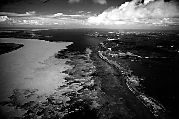
The slope of the lower Amazon is one of the lowest for any terrestrial river, about 2 to 3 cm/km for the 1400 km downstream of Manaus. The reason for this low slope is that the river exhibits delta, rather than floodplain, channel patterns. This is the result of Holocene filling of a great estuary that extended into northern Brazil when the sea level rose rapidly at the end of the Pleistocene. Filling of the estuary by deltaic sediment progressed rapidly as heavy loads were supplied by the Solimões, Japurá, and Madeira Rivers (all of which drain the Andes Mountains). Alleviation was so rapid that tributary arms to the former estuary were dammed and converted to elongate wedgelike dikes, which are named "rias fluviales." Two huge examples occur at the respective mouths of the Tapajós and Xingu Rivers.
Several highways of the Amazônia highway network show up as distinct strips through the rainforest vegetation. The bright response on the imagery is the result of farms provided to new settlers by the Brazilian government. Clearance of the rain forest for farming is an ominous trend, since the forest has little capability of regenerating itself on the lateritic soils of the region. The delicate ecological balance of the region is easily upset. Landsat 77212-13081-7, July 31, 1977.
Continue to Plate F-23| Chapter 4 Table of Contents.| Return to Home Page| Complete Table of Contents|