 |
|---|
| Plate F-24.1 |
 |
| Map |
 |
| Plate F-24.2 |
|
|---|
| Plate F-24.1 |
|
| Map |
|
| Plate F-24.2 |
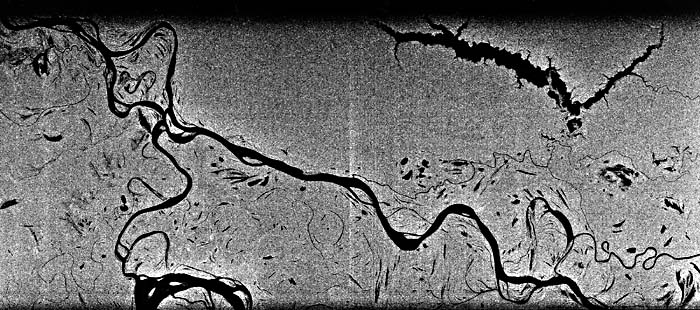
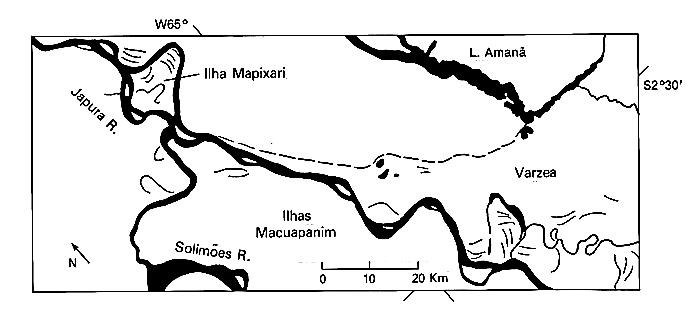
The SIR-A radar image (top of Plate) shows Ilhas (islands) Macuapanim between the Japurá and Solimões Rivers (index map; middle of Plate). The radar highlights the contrast between the terra firme, with its rainforest cover, and the seasonally flooded varzea. The scene is dominated by the varzea topography with numerous cutoffs and scroll topography. Lake Amaua is a prominent ria fluvial.
The scroll bars and long narrow arcuate lakes indicate relatively rapid lateral migration of the rivers through the varzea, or floodplain. The spectacular response of water to the radar (black on the image) highlights these patterns because the intervening forest canopy has a diffuse scattering (bright on the radar image). The scroll topography can be used to estimate the size and shape of former river meanders.
Channel migration on the Solimões occurs during times of varying discharge. At rising stage, the river can undercut its banks, reworking sediment that has been stored there. Huge landslides, called "terre caidas," can develop during falling stage (Sternberg, 1975).
The Rio Japurá shows a transitional anastomosing- to-meandering pattern. Islands in its channel are elongate and vegetated. The nonvegetated islands of typical braided streams are lacking. The Japurá may be less anastomotic than the Solimões because of its smaller size. R. J. Gibbs (1967) estimates that the discharge of the Solimões is about 3.3 times greater than that of the Japurá at their confluence. It has also been proposed that the lower Japuráis influenced by buried structures beneath the Neogene sedimentary fill. It has a series of linear segments that could reflect fault control.
The Japurá carries a considerable sediment load from the Andes Mountains and their forelands in Columbia. It generally flows on alluvial plains that are free of rapids. The varying sediment loads of Amazon Basin rivers are probably the most important controls on fluvial geomorphic features (Baker, 1978a). In the local descriptive language, the sediment-charged rivers are called "rios blancos" (white rivers). The color, really more a muddy-yellow than a white, is caused by very large suspended loads. Both the Japurá and the Solimões are prolific conveyers of sediment.
Rivers that do not drain the Andes are relatively impoverished in sediment. The "black" rivers, like the Rio Negro, and the "green rivers," including the Tapaj—s and Xingu, drain crystalline shield areas. The latter provide a sandy bedload but almost no suspended load. Because of the immense varieties of sediment loads, discharges, and source terrains, the Amazon River Basin contains a fascinating complex of different types of river systems.
| Figure F-24.1 | Figure F-24.2 |
|---|---|
 |
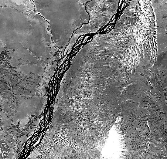 |
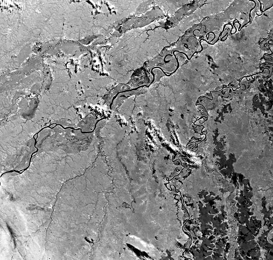
Figure F-24.1 shows another area of the western Amazon Basin, 800 km south of the one described above. The Landsat scene (50129-14022-4, July 8, 1984) shows the Madre de Dies River in northern Bolivia. On its southwest (lower left) to northeast (upper right) course, its pattern changes from low sinuosity, single-channel to low sinuosity, multichannel (anastomosed) to high sinuosity. The Beni River, which flows northward on the east (right) half of the image also shows a marked downstream increase in sinuosity. Both rivers have pronounced varzeas with scroll topography, oxbows, and paleochannel patterns. The terra firme uplands have angular tributary patterns that may indicate structural control.
For comparison, Figure F-24.2 is a Landsat scene of the Zaire (Congo) River in west-central Africa (Landsat 50126-08320-4, July 5, 1984). The Zaire is the world's second largest river in annual discharge and is found at a similar latitude and environment as the Solimões. It has a pronounced anastomosed pattern with large alluvial islands. (Savat, 1975)
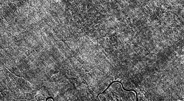
At the bottom of the Plate is a RADAM (Radar Amazon) image (sheet NA19-2-C) in X-band (3-cm wavelength) acquired with a depression angle less than 150 and at a resolution of 12 m from a commercial airborne radar. RADAM was a Brazilian program in airborne radar mapping centered on a 5 million km2 region of the Brazilian Amazon. The project included groundtruth collection at thousands of study sites and resulted in a wealth of data for development plans in the region.
The image depicts an area of small Amazon tributaries near the Uaupés River, a Rio Negro tributary in far northeastern Brazil. Note the detail of surface typography generated by the RADAM image as a result of the radar shadowing effect that occurs at the relatively low depression angle. The much larger depression angle (400) of the SIR-A system does not give this effect.
The intricate dissection pattern emphasized by RADAM has been interpreted by Tricart (1975) as evidence for a relict drainage. He proposes that the relatively dry full-glacial episodes of the Pleistocene were sufficient to change the land cover from rainforest to savanna. The uplands were then subject to intense fluvial dissection, yielding high sediment loads to the Amazon tributaries. The change to interglacial conditions in the last 10000 years has resulted in the stabilization of the dissected interfluves as rain forest returned. SIR-A Image, Data Take 24G, 1981.
Continue to Plate F-25| Chapter 4 Table of Contents.| Return to Home Page| Complete Table of Contents|