 |
 |
|---|---|
| Plate F-27 | Map |
|
|
|---|---|
| Plate F-27 | Map |
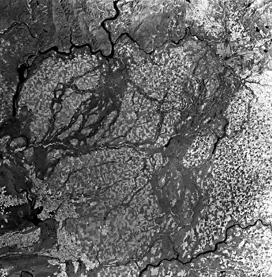
This Landsat scene shows a region that was subjected to perhaps the most remarkable fluvial processes on the planet Earth. The Columbia Basin of eastern Washington is a lowland surrounded by the Cascade Mountains to the west, the Okanogan Highlands to the north, the Rockies of Idaho to the east, and the Blue Mountains to the south. The bedrock comprises the Columbia River Basalt Group, tholeiitic flood basalts erupted between 16.5 and 6 million years B.P. (Swanson and Wright, 1978). Deformation of the basalt surface during the Late Neogene produced anticlines and monoclines that deformed the basalt surface.
During the Pleistocene, the basalt surface became thickly mantled with loess comprising the Palouse Formation. Because of the rain shadow effect of the Cascade Mountains, the Columbia Basin has an arid to semiarid climate during the present interglacial period. However, full-glacial conditions were extremely cold and dry. The loess, which displays a patchwork pattern of wheat farms on the Landsat scene, was emplaced by glacial period winds.
| Figure F-27.1 | Figure F-27.2 |
|---|---|
 |
 |
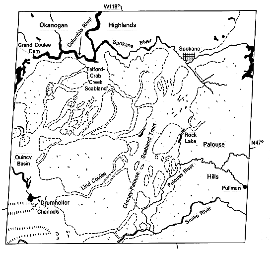
The northern margin of the Columbia Basin, shown in this image, is actually a tilted plateau in which the basalt dips to the southwest. Glaciers advanced over much of the Okanogan Highlands, reaching portions of the plateau during the last major glaciation. The glaciation impounded great lakes in the Columbia River drainage. Largest of these was Lake Missoula, held by an ice dam in northern Idaho. Lake Missoula covered a large area of western Montana and temporarily held as much as 2 x 10¹² m3 of water. The glacial dam in northern Idaho failed repeatedly, releasing the lake water in discharges as great as 2 x 10⁷ m3/s. The resulting floods were the greatest that can be documented in the geologic record of river activity (Baker and Bunker, 1985). The floods spilled across the northern rim of the plateau, eroding a great plexus of flood channelways. The channels appear as darker grays on the Landsat scene because the loess cover was locally eroded, exposing the dark basalt (Figure F-27.1). In the 1920s, a University of Chicago geology professor, J. Harlan Bretz, did extensive studies in this region, which he named "Channeled Scabland." In a fascinating scientific debate during the 1920s, Bretz encountered vehement opposition to his contention that the Channeled Scabland was the product of catastrophic flooding (Baker, 1978b). He insisted that great Late Pleistocene floodflows had filled preflood stream valleys to overspilling, thereby producing divide crossings that converged to comprise an anastomosing complex of channelways scoured in rock and loess.
| Figure F-27.3 |
|---|
 |
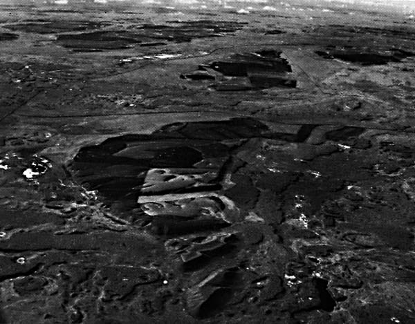
Bretz was able to convince the critics of his theory by careful documentation of the overwhelming evidence for flood-produced landforms in the Channeled Scabland. These features were subsequently shown to be consistent with the flow physics of cataclysmic flooding. Immense bars of boulders and gravel formed wherever large flow separations were generated by various flow obstructions or diversions. Hills of loess were streamlined by the floodflows (Figure F-27.1),and the basalt bedrock was eroded to form a bizarre landscape, known collectively as "scabland," and consisting of erosional grooves, potholes, rock basins, inner channels, and cataracts. Of hydraulic significance are the giant current ripples, composed predominantly of gravel and commonly over 5 m high and spaced 100 m apart (Figure F-27.2). The giant current ripples are directly related to the shear stresses, mean velocities, and stream powers exhibited by the floodflows (Baker, 1973).
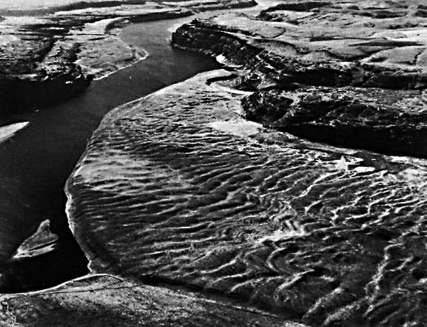
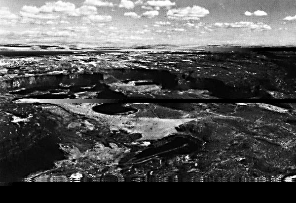
Some of the most spectacular erosional topography in the Channeled Scabland can be seen at Dry Falls (Figure F-27.3), located immediately west of the left center of the image. This cataract is 5.5 km wide and 120 m high. It formed by the recession of a great inner channel that was incised into the basalt layers by the hydraulic plucking action of the deep high-velocity floodwater. Landsat 1039-18143, August 31, 1972.
Continue to References| Chapter 4 Table of Contents.| Return to Home Page| Complete Table of Contents|