 |
 |
|---|---|
| Plate D-1 | Map |
|
|
|---|---|
| Plate D-1 | Map |
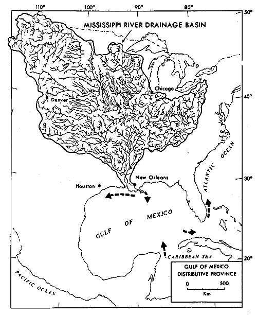
The Mississippi River, the largest river system in North America, drains an area of 3 344 560 km2; this broad drainage area lies between the Appalachian Mountains (east), the Rocky Mountains (west), and the pre-Cambrian Shield of Canada (north) (Figure D-1.1). The average discharge of the river at the delta apex is approximately 15 360 m3/sec, with a maximum and minimum of 57 900 and 2830 m3/sec, respectively. Sediment discharge has been estimated to be about 2.4 billion kg annually. The sediment load brought down by the river consists primarily of clay, silt, and fine sand (approximately 70 percent of the load).
| Figure D-1.1 | Figure D-1.2 |
|---|---|
 |
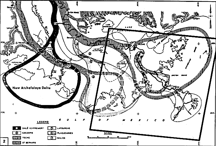 |
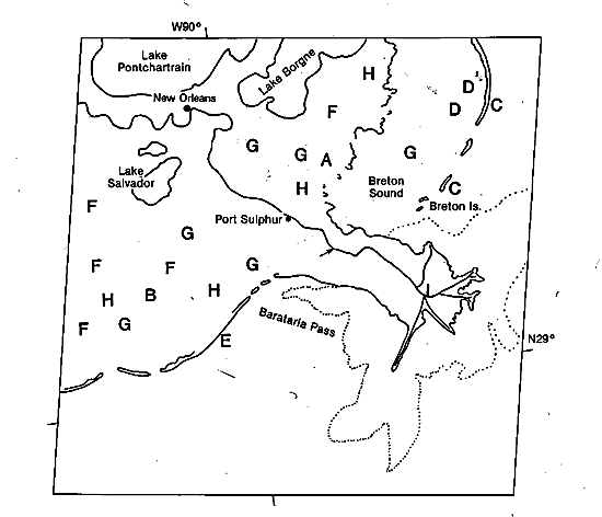
During the past 7000 years, the sites of maximum deltaic sedimentation (delta lobes) have shifted and occupied various positions. Figure D-1.2 (Kolb and Van Lopik, 1966) shows the generalized location of these delta lobes during this time, as well as the satellite data coverage outline of Plate D-1. Plate D-1 and the index map show three of the Mississippi delta lobes, the currently active Birdfoot or Balize delta (I), the oldest abandoned delta lobe, the St. Bernard (A), and the youngest abandoned delta lobe, the Lafourche (B). In Recent times, the seaward progradation and lateral switching of the deltas has led to the construction of a broad coastal or deltaic plain that has an area of 28 568 km2, of which 23 900 km2 is subaerial.
| Figure D-1.3 | Figure D-1.4 |
|---|---|
 |
 |
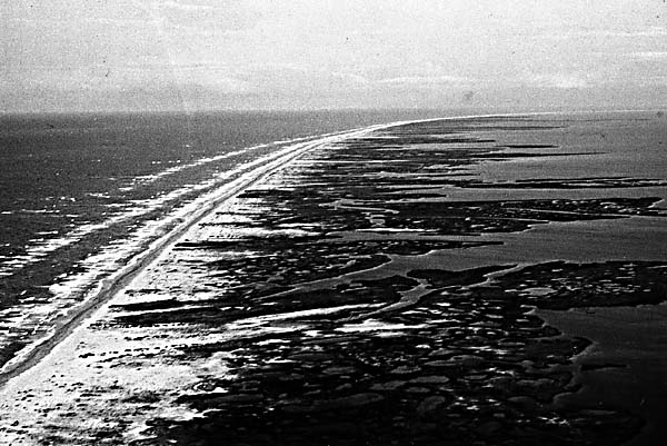
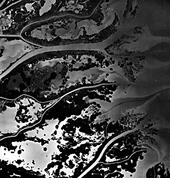
In the abandoned St. Bernard delta, inactive for approximately 3000 years, the geomorphic forms displayed result from transgressive processes or subsidence and marine inundation. After the delta stopped receiving sediments, seaward progradation ceased, and subsidence and wave and current reworking processes became dominant. Along the seaward margins of the delta, the elongate distributaries are reworked by wave processes, concentrating small barrier islands at the tips of the channel mouths. In the interior of the delta, the marsh surface, no longer replenished by overbank sedimentation, begins to break up and small bays begin to form. Increased salt-water encroachment changes the marsh from a freshwater environment to a saline marsh. The salt marsh cannot keep pace with subsidence, and the former delta surface gradually subsides below sea level, forming a broad marine sound. During this period of time, wave reworking and alongshore sediment transport have resulted in the formation of an elongated offshore barrier island chain (C) (Figure D-1.3). In the protected back-barrier sound, where barrier biological processes abound, currents rework the shell-rich sound sediments into broad coquina or shell banks (D).
| Figure D-1.5 | Map D-1.2 |
|---|---|
 |
 |
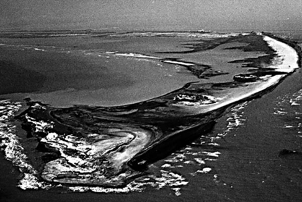
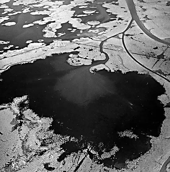
In the younger Lafourche delta (B), the transgressive processes did not have as much time to operate; it has been abandoned for less than 1000 years. Wave and current reworking of the ends of the distributaries resulted in formation of coastal barriers still connected to the mainland (E) (Figure D-1.4). The delta plain has been undergoing subsidence, opening up small bays (G) of brackish water not yet the size of those in the St. Bernard delta. The abandoned distributary channels (F) in both of these relict deltas are well displayed, along with freshwater lakes. Land loss is quite high, amounting to some 100 km2 per year during the past decade over the entire delta plain. Although a rising sea level has contributed to this loss, subsidence, wave reworking, and modification by man, causing salt-water intrusion, have been responsible for a high percentage of this total land loss. On the landward side of the bays and sounds, ragged marsh remnants (H) indicate continuing encroachment of the marine waters.
| Figure D-1.6 |
|---|
 |
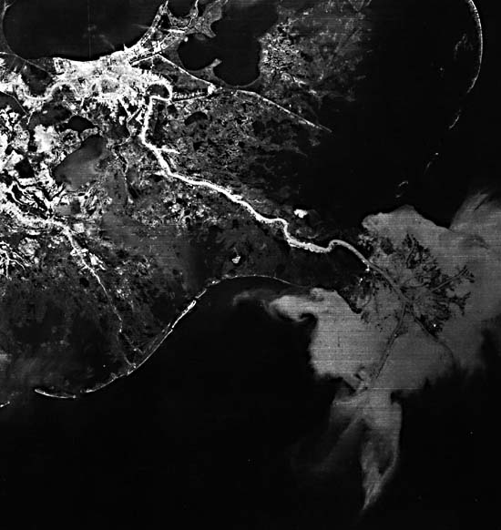
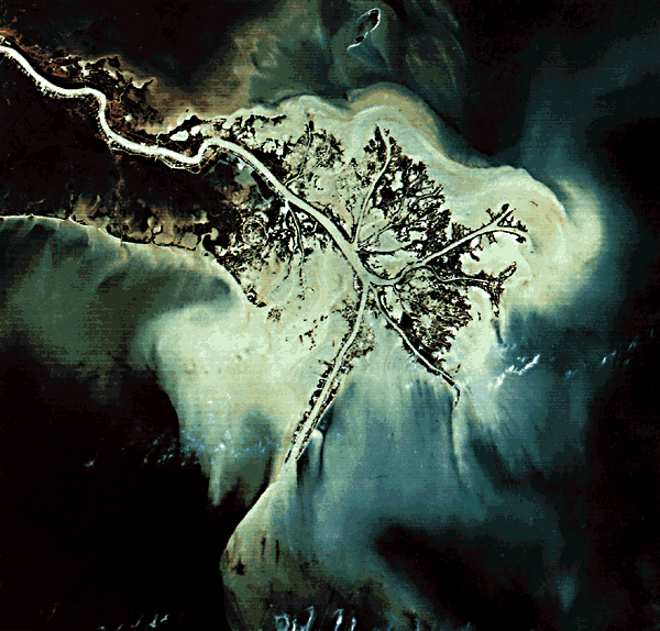
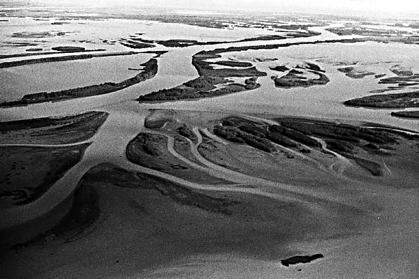
The modern Birdfoot or Balize delta (Figure D-1.5, a Landsat TM subscene) of the Mississippi River is the youngest of the Recent delta lobes; it commenced its seaward progradation some 600 to 800 years ago (Fisk and McFarlan, 1955). This newest delta has prograded over a relatively thick sequence of prodelta clays and, as a result of differential sediment loading, has built a relatively thick but laterally restricted deltaic sequence. In contrast, the older Recent deltas, mostly built over shallow bay and shelf deposits, are laterally widespread and relatively thin. The main channel of the river (A; index map 2) is almost 2 km wide, is 30 to 40 m deep, and displays relatively well-developed natural levees (B). At image top, the natural levees are up to 1 km wide and have heights of 3 to 4 m. Along the active distributaries (C) in the lower delta, the natural levees narrow considerably, to widths less than 100 m, and display heights generally less than 0.5 m.
| Figure D-1.7 | Figure D-1.8 |
|---|---|
 |  |
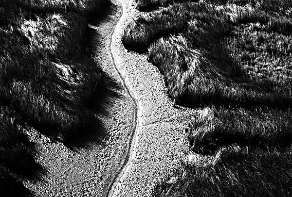
The channels of actively prograding distributaries in the delta display bifurcated patterns (D) both upstream and near their mouths (Figure D-1.6). This type of pattern normally is associated with extremely low offshore slopes and low wave energy. Situated between the channels are interdistributary bays (E) displaying a variety of sizes and shapes. These bays are usually extremely shallow (generally less than a few meters) and contain brackish to normal marine water during periods of low flooding and fresh water during periods of high flooding. Sedimentation rates are relatively low. The bays receive sediment only during periods of overbank flow associated with floods.
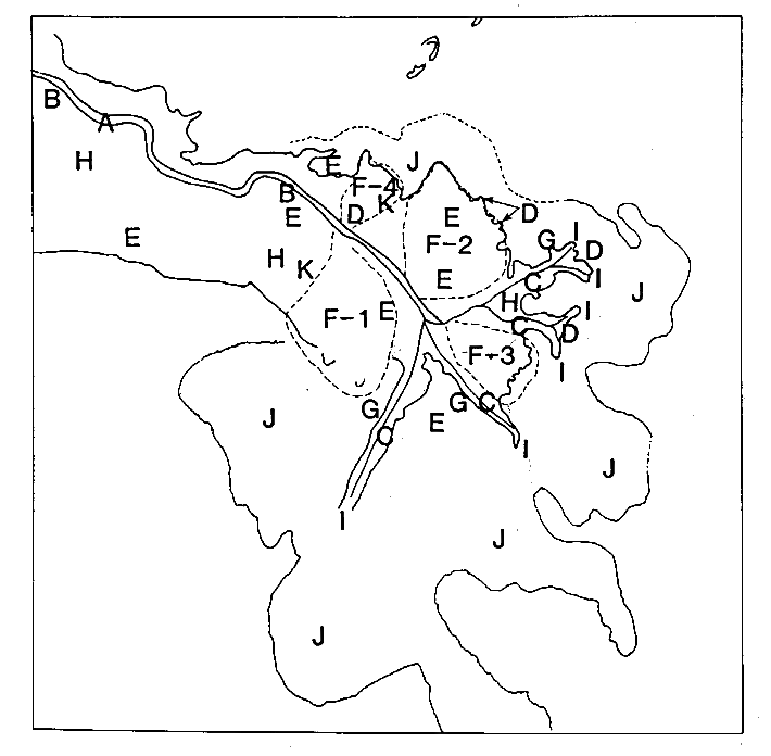
Breaches (crevasses) in the distributary levees result in the formation of subdeltas in the bays (Figure D-1.7). Ultimately, these result in large, complex bay fills or subdeltas of the delta distributary (F1....F-4) (Figure D-1.8). The smaller breaches are referred to as overbank splays (G) and are active for only short periods, generally less than 10 years (Coleman and Prior, 1980). The bay fills comprise the most common geomorphic landforms in the active delta. Each bay fill forms initially as a break in a nearby major distributary natural levee during flood stage, gradually increases in flow through successive floods, reaches a peak of maximum deposition, wanes, and becomes inactive. Owing to continued subsidence, the marsh surface (H) of the bay fill is inundated by marine waters, reverting to a bay environment and thus completing its sedimentary cycle. The mass of sediment resulting from this crevassing process can vary in thickness from 5 to 20 m, covers an area of 150 to 300 km2, and requires 100 to 200 years to complete a cycle. West Bay (F-1) formed by a break in the levee in 1938, Cubits Gap (F-2) in 1962, Garden Island Bay (F-3) in 1872, and Baptiste Collette (F-4) in 1874. Today, these bay fills are undergoing rapid land loss, with destruction of marshes and swamps (Figure D-1.9 and Figure D-1.10), as a result of subsidence and compaction. New bay fills are no longer being formed, due to diking by man to maintain flow in the major navigation channels. Dredged canals (I) are present throughout the image and are constructed as access canals for subsurface hydrocarbon exploration and production. The circular patterns represent well sites associated with buried salt diapiric intrusions.
| Figure D-1.9 | Figure D-1.10 |
|---|---|
 |  |
Immediately seaward of the actively prograding distributaries are the turbid river-mouth effluent plumes (J) (Wright and Coleman, 1971). Deceleration of a turbid plume as it spreads laterally allows the coarser sediment being transported to be deposited, forming the distributary mouth-bar and delta-front environments. The finer grained sediments remain suspended and spread laterally over broad distances, forming a turbid plume (K) that fronts the entire offshore delta; as these fine-grained sediments are deposited, they form the prodelta platform as the distributaries build seaward at rates of 100 to 150 m per year. Landsat 1177-16023-5, January 16, 1973
Continue to Plate D-2| Chapter 5 Table of Contents| Return to Home Page| Complete Table of Contents