 |
 |
|---|---|
| Plate D-8 | Map |
|
|
|---|---|
| Plate D-8 | Map |
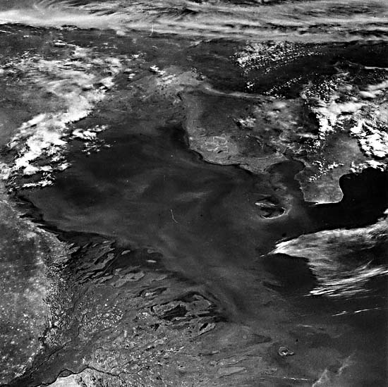
The Volga River, the largest river system in Europe, rises in the Valdai Hills northwest of Moscow and flows through its 3370-km length to discharge into the Caspian Sea. It has a drainage area in excess of 1.3 million km2. Over much of this drainage area, the river traverses a broad, often swampy basin, surrounded by low morainic hills. Within its basin lives nearly 25 percent of the total population of the U.S.S.R., and the river and its tributaries carry about two-thirds of all the riverborne freight in the country. Today, much of the flow is regulated through a series of dams and reservoirs. The Volga is fed mainly by snowmelt. High discharge, in May and June, varies from 20 000 to 36 000 m3/sec, and low discharge, from August through March, is rather constant at 3000 to 5000 m3/sec. Prior to damming, the river delivered 25.5 million tons of suspended sediment and an unknown quantity of bedload to the Caspian Sea (Zenkovich, 1967). On entering the Caspian Sea-a landlocked, once marine body now brackish from freshwater dilution-this load has formed a large (10 400 km2) delta, shown in both the Plate mosaic and a southeast-looking oblique photo (Figure D-8.1) taken during the STS-18 (Shuttle) Mission 5lB.
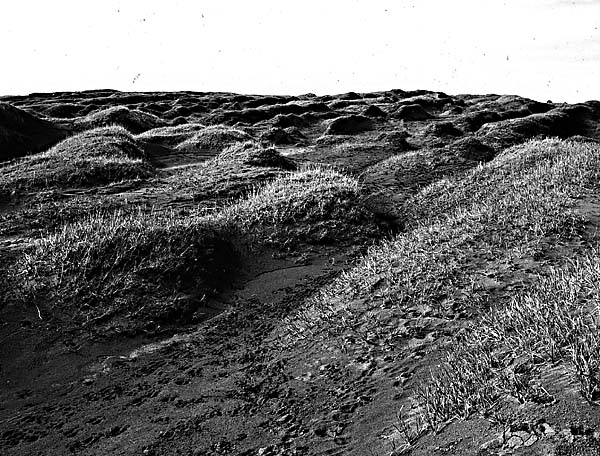
The river system can be described as an erratically discharging river, flowing into a receiving basin whose water level has varied consistently during the Recent. Within the receiving basin, wave and current energy is extremely low. The level of the Caspian Sea has been fluctuating significantly, and in the last 150 years, water level has fluctuated over 6 m; during the period 1930 to 1963, water level dropped 2.6 m. This water-level fluctuation has led to three zones in the delta proper. The higher areas of the first zone are referred to as "Behr's mounds," linear ridges of clayey sands ranging from 400 m to 10 km in length and averaging 8 m in height. Between the ridges are elongated depressions (ilmens in Russian) that fill with water and become either fresh or saline bays. It is believed that these ridges and swales represent coastal banks now stranded by the falling level of Caspian Sea. The delta proper, comprising the second zone, displays low relief (generally less than 1 m) and is the site of active and abandoned channels, interdistributary regions (often containing saline water), small dunes and algal flats, and small, partially vegetated eolian dunes (Figure D-8.2) that derive their sediment from the exposed dry channel courses. The third zone is the submarine part of the delta, which forms a broad platform extending 30 to 60 km offshore.
| Figure D-8.1 | Figure D-8.2 |
|---|---|
 |
 |
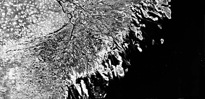
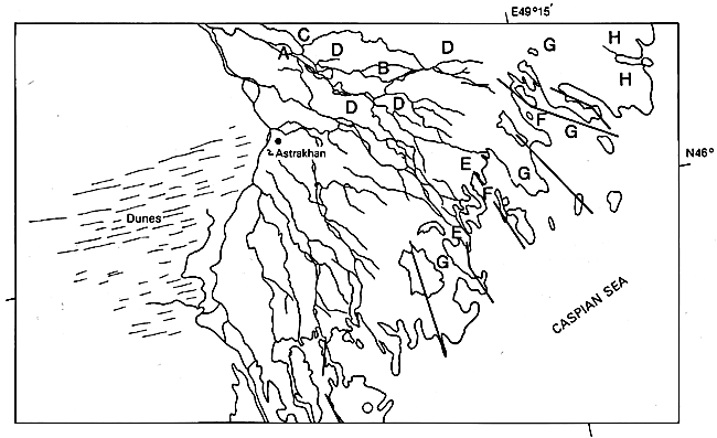
The main eastern distributary, the Sumnitsa (A), enters the delta north of the city of Astrakhan and immediately forms a complex anastomosing channel pattern (B) consisting of numerous dry and abandoned channels, as well as active channels. Flow in the channels is so erratic that, for much of the year, little or no water flows in the channels. Strong winds erode the channel floors and form linear dunes on the overbank areas. The left side (after turning) of the Plate shows the natural levee of the main river channel across which small eolian dunes have been deposited; the source of the sand is the adjacent channel. The active channels that contain river flow are ice bound during the period December through March. Before the construction of dams, these complex channels constantly shifted their position with each flood. North and west of the delta are broad coastal dunes (C), many of which have been stranded inland by the falling level of the Caspian Sea. Many of these show little or no orientation and are generally devoid of substantial vegetative cover. The zones marked "D" are areas of Behr's mounds. A similar extensive system bounds the western flank of the delta, in which interdune areas enclose elongate lakes. The sand ridges have been stranded by the falling level of the Caspian Sea and consist of marine sands reworked by eolian action; they generally contain a high shell content.
In the lower delta, the small distributaries display well-developed, complex, bifurcated channel patterns (E), and because of this process, the few major distributaries that enter the head of the delta have split, producing more than 80 active river mouths in the delta (Figure D-8.1). This figure shows the complex distributary channel patterns of the river mouth and the adjacent mudflats. At the river mouths, many shoals and triangular river-mouth bars (called middle ground shoals in the Mississippi River delta) are the most common geomorphic landform. Relief is very low, rarely exceeding 0.5 m. Immediately offshore is another complex system of subaqueous channels (F) and shallow shoals that forms the delta-front platform, or the foredelta. Because of their small size, most of these are barely visible in the image. All along the front of the delta, mudflats, coquina banks, and muddy sand shoals (G) are present, associated with the rapid progradation of the channels before damming. On the lateral margins of the delta are algal flats and salt pans which have accumulated in those parts of the delta that are no longer active or in depressions that have been stranded by the falling level of the Caspian Sea. Landsat TM 50115-06582-4 (right), June 24, 1984; TM 50122- 07044-4 (left), July 1, 1984.
Continue to Plate D-9| Chapter 5 Table of Contents| Return to Home Page| Complete Table of Contents|