 |
|---|
|
|---|
 |
 |
|---|---|
| Plate C-19b | Plate C-19c |
Reef-building corals thrive in all mud-free shallow ocean water where surface water temperatures remain above 18°C. The region includes almost all tropical oceans today and warm shallow subtropical seas. The coral polyps are pelagic until they settle on a hard substrate in clear water less than 70 m deep. Corals support symbiotic photosynthetic algae in their tissue, so that clear shallow water is essential for reef growth. There is such an extensive shallow water zone in the tropics today, especially among the island arcs of southeast Asia and the western Pacific basin, that one of the most fundamental divisions of coastal types is that between coralline and noncoralline coasts (Davies, 1980).
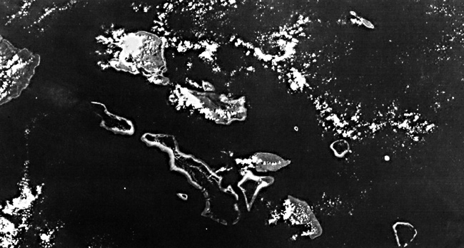
Indonesian island arcs are especially notable for reefs growing on active tectonic foundations. The upper image in the Plate montage shows the Toekang Besi archipelago that trends southeast into the Banda Sea from the southeast arm of Sulawesi (Celebes) Island. Hamilton (1979) suggested that the foundation of these islands is a fragment of continental crust torn from New Guinea, now almost 1000 km to the east. Umbgrove (1947, p. 762) noted a linear arrangement for the islands, with southeast-trending atolls on the southwest side, then a row of elevated islands, followed by another row of atolls, and finally on the northeast, a row of small islands with uplifted coral reef terraces. He interpreted the chains of atolls as growing on subsiding fault blocks or anticlinal ridges. The alternating belts of high and low islands certainly favors control by active tectonic lineaments, but the net movement has not been ascertained. (Uplift rather than subsidence is more likely.)
| Figure C-19.1 | Figure C-19.2 |
|---|---|
 |
 |
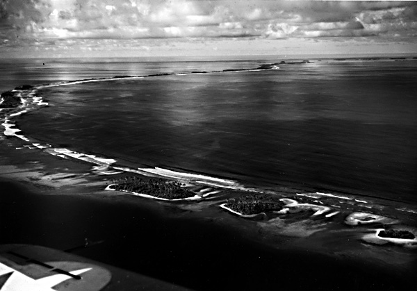
In the central Pacific are several chains of islands administratively called the U.S. Trust Territory of the Pacific Islands, or Micronesia. Covering a total oceanic area equal to that of the 48 conterminous United States, the total land area of Micronesia is less than two-thirds the size of Rhode Island. All but a few of the Micronesian islands are atolls, rising from oceanic depths to barely above sea level and enclosing lagoons that are commonly 30 to 40 m in depth (Wiens, 1962; Shepard, 1970). At the western end of Micronesia lies the Belau (Palau) fringing reefs located 900 km east of Mindanao in the Philippines (lower left image in Plate). This reef complex, which stretches about 160 km along a north-northeast line, consists of a group of islands along the east side of the lagoonal waters. The largest, Babelthuap, is about 50 km in length and has several peaks above 200 meters. In the Plate, these heavily vegetated islands show up as bright tones in the Band 7 image (left center), but the fringing atoll reefs are nearly invisible; in Band 4 (not shown), these reefs would stand out, but the islands would be difficult to pick out.
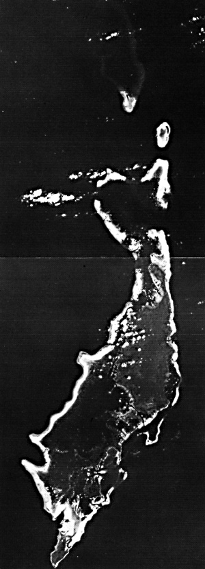
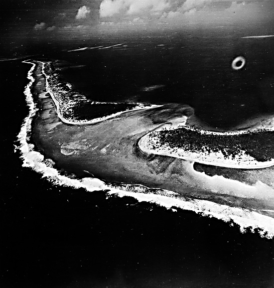
In eastern Micronesia, Jaluit atoll (Figure C-19.1, part of a Landsat image) in the Marshall Islands is typical of reef islands that enclose a lagoon without interior land. Jaluit is more elongate (55 by 36 km) and cuspate than many Micronesian atolls. Southeast Pass and Southwest Pass are clearly visible at low tide because of the maze of smaller plug reefs that thrive inside the main reef rim, nourished by strong tidal currents at the inlets. Typhoons are common, and in 1958, one stripped many of the islets of their trees and soil (McKee, 1959). The northeast Trade Wind is dominant over Jaluit. Because ocean currents also come from the east, the eastern side has higher waves and stronger currents that encourage more vigorous growth on that side, which in turn provides more broken coral debris for storms to throw onto the reef flat. Inside the Jaluit lagoon are uncounted numbers of small pinnacle or patch reefs, some of which break surface above the 20- to 30-m deep floor.
| Figure C-19.3 |
|---|
 |
Reefs also form a cluster of atolls in the Maldive Islands south of the tip of peninsular India (lower right image in Plate). These islands have built up along high points on the Chagos Laccadive Plateau that lies between the mid-Indian spreading ridge and the Chagos Trench.
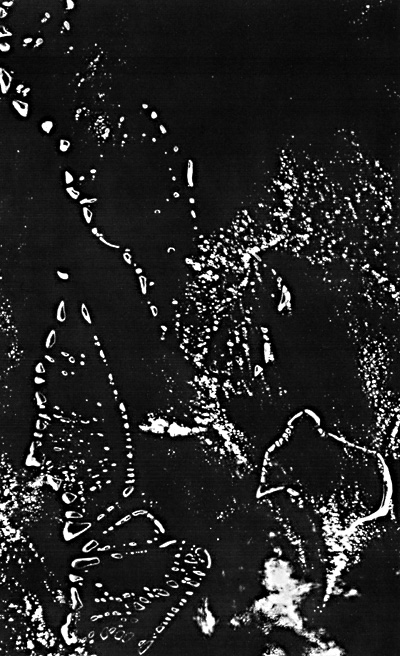
Figure C-19.2 and Figure C-19.3 are aerial views of Jaluit and Arno atolls, respectively, in the Marshall Islands.
The origin of oceanic atolls, which Darwin (1842) called "enigmatic" structures, has been one of the classic problems of geology. Most researchers now agree that atolls like Jaluit were established on former midocean basaltic volcanoes (some are now guyots) that originated near active spreading ridges but have since been displaced to their present positions. As new oceanic lithosphere is created at the ridge crest, it moves outward and cools. Thermal contraction is an adequate mechanism to explain how hot young oceanic lithosphere can form at shallow depths (2 to 3 km) near a spreading ridge and then move outward over the next 30 to 60 Ma while sinking to an average oceanic depth of 4 to 5 km. Darwin's theory that oceanic atolls began on slowly subsiding foundations has gradually been confirmed. Borings on Eniwetok atoll, near Jaluit, reached basalt basement at 1200 and 1400 m after penetrating shallow water reef limestone of Eocene age. During most of Cenozoic time, these atolls have maintained their surfaces in or close to the breaker zone while their foundation sank at a rate of a few centimeters per 1000 years. Landsat Montage.
Continue to Plate C-20| Chapter 6 Table of Contents.| Return to Home Page| Complete Table of Contents|