 |
 |
|---|---|
| Plate C-23 | Map |
|
|
|---|---|
| Plate C-23 | Map |
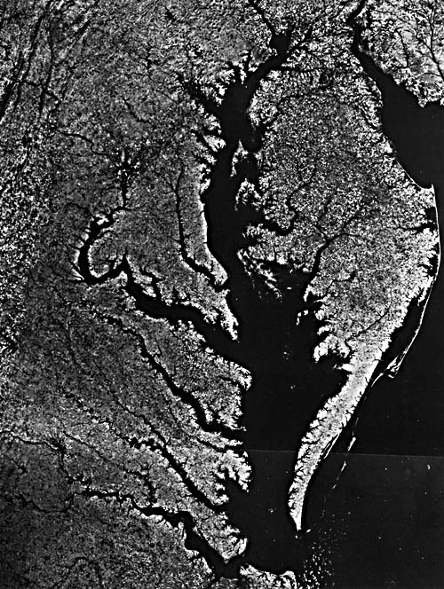
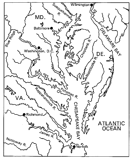
This two-image Landsat mosaic of the mid- Atlantic Coast includes the southern tip of New Jersey, the Delmarva (Delaware/ Maryland/Virginia) peninsula, and the Norfolk/Virginia Beach area to the south. These major landforms are bounded by the Delaware and Chesapeake Bays, both drowned river valleys. The Chesapeake Bay, with its many tributaries, has a total tidal shoreline of approximately 1000 km almost equally divided between the states of Maryland and Virginia, making it the largest estuary in North America.
Estuaries are defined as semi-enclosed coastal bodies of water that freely connect with the ocean and within which seawater is measurably diluted with fresh water from runoff (Pritchard, 1967). The main source of freshwater input in the Chesapeake is the Susquehanna River, which drains a large watershed extending into Pennsylvania and New York. Other tributaries, such as the Potomac and James Rivers on its Western Shore, contribute substantial quantities of water, with the eastern shore tributaries adding only a little more. Salinity varies along the roughly north-south axis of this estuary from full- strength seawater (35%) at the mouth to completely fresh water near the head north of Baltimore. Because of the brackish water conditions, estuaries teem with life, and many commercially and recreationally important finfish and shellfish are dependent on estuaries during at least some portion of their life cycle.
The tidal range in the Chesapeake Bay ranges from an average of 1 m at its mouth to less than 30 cm near its head. The Bay is generally very shallow, averaging 3 to 6 m deep, except for the narrow deep channel near the Western Shore, which represents the drowned river channel of the Susquehanna River. Because of its shallow depth and extremely long length (over 300 km), the astronomical tide takes over 12 hours to propagate from one end of the Bay to the other. Therefore, the Chesapeake Bay has the distinct characteristic of containing two high tides along its length (say at Norfolk, Virginia, and Baltimore, Maryland) at the same time.
Estuaries are ephemeral features on a geologic scale; lifetimes are usually limited to a few thousands to at most a few tens of thousands of years (Schubel, 1971). All present- day estuaries worldwide are thus very young geologically; they formed during the most recent rise in sea level, which began about 15 000 years ago. Estuaries along the trailing edge of passive margin coasts, which are dominated by low, gently sloping wide coastal plains, were formed by the drowning of river valleys. Other estuaries have been created by tectonic processes (San Francisco Bay, California), by glacial ice motion (fjords of Norway and Sweden), and by development of barrier islands (Atlantic coast of Delmarva). A rise in sea level can prolong the lifetime of an estuary, but many large cities, such as Norfolk, Virginia, and Washington, D. C., would be inundated if the rise were to exceed a few meters.
| Figure C-23.1 | Figure C-23.2 |
|---|---|
 |
 |
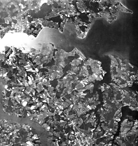
With rising sea levels, low-lying regions are submerged. This has been the primary response of the shoreline along the Eastern Shore of the Chesapeake Bay. Here, farmlands are being slowly invaded (Figure C-23.1) by the brackish water so that cornfields are changed to marshlands (termed upland conversion). This landward migration of the salty waters and associated flora is presently occurring at rates of up to 1 m per year in low-sloped areas of the Eastern Shore. In addition, sea-level rise results in actual erosion of sediment along the outer edge of the land (the Bay shoreline). Depending on shore type, which ranges from low to fairly high cliffs of unconsolidated sediments along the Western Shore to generally low banks, beaches, and marshes along the Eastern Shore, there is a wide range of erosion rates. The highest rates of historic erosion approach 3 m per year, while the baywide average is 0.3 to 0.6 m per year, providing large quantities of sediment. The small marshy islands in the mid-Bay are rapidly eroding; some have disappeared completely in historic times. Other sources for Bay infilling result from landward transport of littoral sediments through the mouth by tidal and wave-generated currents and riverine inputs from the numerous tributaries, primarily the Susquehanna River.
Estuaries are clearly dominated by natural processes, but human activities can also affect the infilling of estuaries. Until recently, relatively poor soil conservation practices throughout the drainage basin of the Chesapeake Bay have greatly increased the sediment yield and hence sedimentation rates in nearshore areas. Such anthropogenic influences can shorten the lifetime of an estuary by a factor of 2 or more (Schubel, 1971).
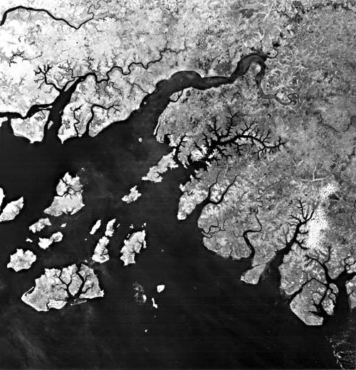
The low-lying terrain of the West Africa coast has likewise been greatly influenced by the Holocene rise in sea level. Rivers have become tidal-influenced, converting them into a series of small estuaries and creating a very irregular coastline (Figure C-23.2). This coast is microtidal (<2 m) and semidiurnal, as is the U.S. mid-Atlantic Coast (Davies, 1980). The large estuary of the Geba River is quite similar to the Choptank and Nanticoke tributaries of the Chesapeake Bay. The abundant river discharge due to the high rainfall (2000 to 3000 mm/yr (Orme, 1982)) results in considerable flow of terrigenous sediments onto the continental shelf. Although the shore morphology is characterized as lowland coastal swamps and tidal creeks, the erosion-resistant rocks (Paleozoic cover over a Precambrian platform) form the irregular coastline of Guinea-Bissau, as well as the numerous offshore islands. (GCW: S. P. Weatherman) Landsat 1079 - 15135-7 and 1080-15187. October 1972.
Continue to Plate C-24| Chapter 6 Table of Contents.| Return to Home Page| Complete Table of Contents|