| Figure 8.1. Global circulation patterns. | 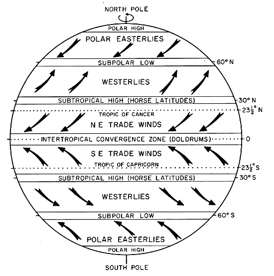 |
|---|
We live at the bottom of a gaseous envelope that is gravitationally bound to the planet Earth. Our atmosphere is generally separated into two zones-the homosphere at low altitudes where mixing produces a uniform composition of gases, and the upper heterosphere. The homosphere consists of 78 percent nitrogen, 21 percent oxygen, and 0.9 percent argon. Water vapor, carbon dioxide (0.03%), and other molecules are present as minor constituents. The lowest layer of the homosphere, which contains about 80 to 90 percent of the mass of the atmosphere, is the troposphere, which is defined as the layer where temperature decreases with increasing elevation. Most of the Earth´s weather occurs in the troposphere. The heterosphere is divided into four subzones, each with a distinct composition. Above the heterosphere is the exosphere, which is the top of the atmosphere. It begins about 600 km above the surface of the Earth and extends up to the altitude at which the average density of the atmosphere falls to the average density of the interplanetary medium. Using this criterion, the upper boundary of the atmosphere is about 20000 km above the surface of the Earth (Smith and West, 1983).
The circulation of a planetary atmosphere is a complex process because of rotation of the planet and inclination of its axis. The Earth´s axis is inclined 23 1/2° from the ecliptic. Vertical rays of the Sun strike 23 1/2°N latitude, the Tropic of Cancer, at summer solstice in late June. At winter solstice, the vertical rays strike 23 1/2°S, the Tropic of Capricorn. The inclination of the axis causes seasonal changes in the global circulation system.
The circulation of the atmosphere is further affected by the rotation of the Earth, which introduces the Coriolis Effect. The Coriolis Effect illustrates Newton´s first law: a body in motion will remain in motion in the same direction unless acted on by some outside force. The rotational velocity of a planet is zero at the poles and maximum at the equator. If a missile were fired true north from the equator, it would acquire the rotational velocity of the equator. As the missile progresses northward, it would retain the rotational velocity of the equator. This velocity would be greater than the rotational velocity of the Earth under it. Inasmuch as the Earth rotates west to east, the missile would be deflected toward the east. The Coriolis Effect causes moving objects to be deflected toward the right in the northern hemisphere and toward the left in the southern hemisphere.
The global circulation pattern of Earth is illustrated in Figure 8.1. The circulation of air between the hot equatorial region and the cold polar regions creates pressure belts that influence weather. In 1735, George Hadley suggested that one large convection cell existed in each hemisphere for a nonrotating Earth. According to Hadley, the simple convection cell consisted of hot air rising at the equator, cooling as it moves toward the poles, descending as cold air over the poles, and warming as it moves over the surface toward the equator.
| Figure 8.1. Global circulation patterns. | |
|---|
In the zone between the equator and about 30° latitude, the surface atmospheric flow is toward the equator, and the flow aloft is poleward. This area is referred to as the Intertropical Convergence Zone (ITCZ). It is an equatorial low and is a zone of calms or light variable winds, known to mariners as the doldrums. The location of the ITCZ varies seasonally and has been measured as far north as 40°N during a northern hemisphere summer (Lutgens and Tarbuck, 1979). Its migration significantly modifies precipitation, with the length of the dry season depending primarily on the distance of an area from the ITCZ.
Around 30° latitude, the poleward airflow begins to subside in subtropical high-pressure belts. The subsiding air is relatively dry because its moisture has been released near the equator in the tropical rainforests. Near the center of this high-pressure zone of descending air, called the Horse Latitudes, the winds at the surface are weak and variable. The name for this area is believed to have been given by Colonial sailors who, when sometimes becalmed at these latitudes while crossing the oceans with horses as cargo, were forced to throw a few of them overboard to conserve water. Over the continents, this subsidence zone is the site of many of the world´s deserts.
The subsiding air that then flows equatorward from the subtropical high-pressure belts is deflected toward the west in both hemispheres by the Coriolis Effect. Because wind direction is the direction from which the wind is blowing, these winds are referred to as the northeast trade winds in the northern hemisphere and the southeast trade winds in the southern hemisphere. The trade winds meet at the doldrums.
The poleward surface flow away from the equator beyond the Horse Latitudes produces winds referred to as westerlies. They meet easterlies from the polar highs at a subpolar low-convergence zone at about 50 to 60 degrees latitude.
The atmospheric circulation systems of other terrestrial planets with gaseous envelopes also depend on the orbit and inclination of the planets and the composition parameters of the atmospheres. Leovy (1977) finds that the atmosphere of Mars behaves like a rarefied version of the Earth´s atmosphere. Because of its retrograde rotation and extremely high pressure, the atmospheric dynamics of Venus are considerably different from those of the Earth. Seasonal variations on Venus are negligible because of its small orbital eccentricity and the 3° inclination of its axis from the ecliptic. In addition, the 243-day rotation minimizes the Coriolis Effect. At cloud height, the atmosphere circulates the planet in about 4 days. The complex global circulation patterns of the atmosphere of Venus are not fully understood (Schubert, 1983).
Fujita (1981) proposes that a planet´s atmospheric motion be divided into five scales. The largest scale is the equator length, for the Earth, 40 000 km. The dimensions of the scales decrease by two orders of magnitude per scale, and the smallest scale on Earth has a maximum length of 40 cm.
Wind is a stream of air flowing because of a difference in atmospheric pressure between two points. Winds blow from areas of high pressure to areas of low pressure. Near the ground, wind is affected by friction and by changes in topography. Winds may be seasonal, sporadic, or diurnal. Their intensities on Earth range from gentle breezes to tornadoes with speeds in excess of 60 m/sec (Fujita, 1981).
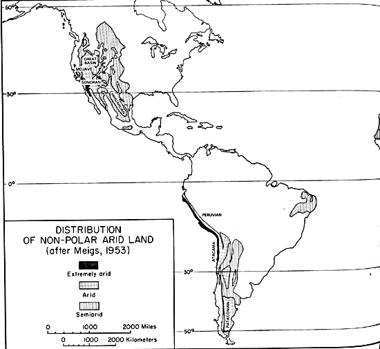
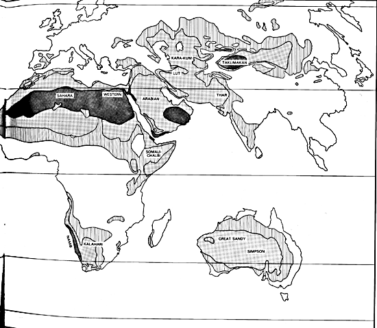
Approximately one-third of the land surface of this planet is considered to be desert-barren land with meager rainfall that can support only sparse vegetation and a limited population. A widely accepted arid-zone classification system was suggested by Meigs (1953) and is shown in Figure 8-2.
Desert regions on Earth have been divided into three categories according to the amount of precipitation they receive. Extremely arid lands have at least 12 consecutive months without rainfall, arid lands have less than 250 mm of annual rainfall, and semiarid lands have a mean annual precipitation between 250 and 500 mm. Arid and extremely arid land are deserts, whereas semiarid grasslands generally are referred to as steppes. Savannas, which are treeless plains with distinct wet and dry seasons, lie between deserts and tropical rain forests.
| Figure 8.2. Nonpolar deserts of the world. | |
|---|---|
 |
 |
Trade-Wind Deserts
The trade winds are two belts on the equatorial sides of the Horse Latitudes. As these surface winds move from higher to lower latitudes, they become warmer. In addition to being dry, the winds dissipate cloud cover, allowing more sunlight to heat the land. Trade-wind deserts are sometimes referred to as low-latitude deserts.
Most of the major deserts of the world lie in areas crossed by the trade winds. The world´s largest desert, the Sahara of North Africa, with a maximum recorded air temperature of 57°C (Cooke and Warren, 1973), is a trade-wind desert. The Taklimakan Desert of China is predominantly a trade-wind desert although its northern and southern borders are in the rain shadows of two mountain ranges.
Midlatitude Deserts
The midlatitude deserts occur between 30 to 50° latitude, poleward of the subtropical high-pressure zones. They have a wide temperature range with lower winter temperatures than those found in trade-wind deserts. Midlatitude deserts normally develop far from the ocean in interior drainage basins. The Lut Desert in Iran and the Sonoran Desert in the United States and Mexico are midlatitude deserts.
Rain-Shadow Deserts
Rain-shadow deserts are created by mountain ranges that prevent moisture-rich clouds from reaching areas in the lee of the range. Rain or snow is precipitated as the air rises over the mountains, and a desert is formed on the lee-side "shadow" of the range. Rain-shadow deserts are recognized easily from space by the absence of vegetation on the lee side of the mountains. These deserts sometimes are called orographic deserts. The Turpan Depression, Plate E-24, is a rain-shadow desert.
Coastal Deserts
Coastal deserts generally are found on the western edges of continents near the tropics of Cancer and Capricorn. They have the smallest temperature range of all deserts (Meigs, 1966). These deserts are affected by cold ocean currents parallel to the coast. These currents create high-pressure zones that lower the temperatures and cause temperature inversions. In coastal deserts, local wind systems often override the trade winds. These deserts are, therefore, less stable than other deserts and are dependent on ocean currents (McCauley et al., 1977). Winter fogs, which reduce solar radiation and decrease the temperature, are frequent in coastal deserts. Many coastal sand dunes are relatively complex because they are at the interface of terrestrial, oceanic, and atmospheric systems (Pye, 1983). The world´s driest desert is the Atacama of South America, a coastal desert shown on Plate E-10.
Monsoon Deserts
Changes in the position of the ITCZ lead to monsoons in low latitudes. The term monsoon is derived from an Arabic word meaning season and refers to a wind system with pronounced seasonal reversals. Monsoons develop in response to temperature variations between continents and oceans. The two major monsoon systems on Earth are in northern Australia and West Africa. Lesser monsoon systems affect the deserts of central Asia. The southeast trade winds of the southern Indian Ocean provide heavy summer rains in India when they move onshore. As the monsoon crosses India, it loses moisture on the eastern slopes of the Aravalli Range. The Rajasthan Desert of India and the Thar Desert of Pakistan (Plate E-21) are parts of a monsoon desert region west of the range.
Polar Deserts
Polar deserts are in currently nonglaciated areas with annual precipitation of less than 250 mm, and a mean warmest month temperature of less than 10°C. The polar deserts on Earth, which have a total area of nearly 5 M km2, generally consist of bedrock or gravel plains. Sand dunes are not prominent features, but snow dunes are common in areas where precipitation is locally more abundant.
Because most moisture in polar deserts is in the solid rather than the liquid state, there are differences between polar and other deserts (Péwé, 1974). Temperatures in polar deserts often fluctuate above and below the freezing point of water. Alternate freezing and thawing creates patterned textures, such as contraction polygons that may be 15 to 30 m in diameter. These sand-wedge polygons are not usually seen in other deserts.
Paleodeserts
Patterns characteristic of dunes in sand seas may be recognized on images even though they are located in presently nonarid environments (see, for example, Plate F-8). Many such relict dunes are in areas in which annual rainfall is now 700 to 1500 mm, and some extend into areas presently occupied by tropical rain forests (Goudie, 1983). Ancient sand seas, changing lake basins, archaeological data, relict fluvial topography, and vegetation analyses indicate that climatic conditions have changed over vast areas of the Earth. Goudie (1983) suggests that, during most cold phases of the Pleistocene, parts of the deserts were more arid than they are today. Sarnthein (1978) notes that 10 percent of the land between 30°N and 30°S is presently covered by sand seas. About 18 000 years ago, sand seas in two vast belts occupied almost 50 percent of this land area. As today, tropical rain forests and savannas existed between the two belts.
Many sandstones are considered to be eolianites, sedimentary rock formed by consolidation of sediment deposited by wind. Some investigators hold that distinction between eolianites and certain fluvial sediments can be very difficult, but eolianites may often be recognized by large- scale cross bedding with high-angle dips, ripple marks, slump marks, and contorted bedding characteristic of dry sand (McKee, 1979a).
As described by Glennie (1970), vector analysis and stereographic plots may be used to determine prevailing paleowind directions when the dunes were formed. Bigarella (1972) considers that the paleolatitude of eolianites may also be determined. He refers to a latitude that marks the mean boundary between the trade winds and the westerlies as the "wheel-round latitude" (Bigarella, 1972, p. 41). This latitude is marked by a distinct change in the alignment of sand dunes and dune movement. He argues that the present wheel-round latitude in northern Africa is 25°N, but comments that other investigators have placed the Pleistocene wheel-round latitude at 15°N. This difference suggests a climatic boundary shift of more than 1000 km.
Arid-land geomorphic features are usually excellent indicators of paleoclimatic conditions. In some environments, however, differentiating between response to a global climatic change and response to regional uplift of an associated mountain range is difficult. Stoertz and Ericksen (1974) address this problem by noting that regional uplift causes the crowding of playas, salt crusts, lake shores, and piedmont alluvial slopes in parts of Chilean basins. Other anomalies they observed in one basin include the presence of lake sediments along the eastern side high above the western playas and the diminishing height of terrace scarps around salt crusts toward the west. Climatic change, as opposed to regional uplift, is indicated by the absence of extensive and consistent regional asymmetry.
The Nebraska Sand Hills, Plate E-14, is an inactive, probably Holocene, 57 000-km2 dune field in central Nebraska. The largest sand sea in the western hemisphere, it is presently stabilized by vegetation and has an annual precipitation of 406 to 610 mm (Ahlbrandt and Fryberger, 1980). These authors found the dunes to be of crescentic and dome types as high as 91 m. They have a maximum thickness extending to 34 m below interdune surfaces. Present-day effective winds, calculated from weather station data, differ from paleowind regimes inferred from the internal structures of the dunes. A modern analog may be Lake Chad, Plate E-8, where large-scale crescentic dunes occur in an arid area in which the climate has changed episodically.
Although paleoeolian depositional features have been recognized widely, little work has been done until recently in recognizing paleoeolian erosional features. Only with the advent of space imagery was the regional extent of some eolian erosional features recognized (McCauley et al., 1977; Mainguet, 1983).
Martian Sand Seas
Although Mars has a diameter of about one- half that of Earth and a surface atmospheric pressure about 1 percent that of Earth, it has a north circumpolar sand sea with an area of at least 700 000 km2, greater than the Empty Quarter, which is the largest sand sea on Earth (Breed et al., 1979b). The martian sand sea, Plate E-15, consists predominantly of crescentic dunes and is visible on plains south of the perennial ice cap of the north polar area. Smaller dune fields are found elsewhere on the planet, including inside many large craters in the north and south polar regions. Eolian depositional features of polar deserts on Earth are studied as analogs for martian geomorphology (Morris et al., 1972).
Eolian Processes on Venus
Venus is frequently called the Earth´s twin because it is close to the Earth in radius, mass, density, and surface gravity. The relation is only sororal, however, Venus has a retrograde rotation period of 243 days, a mean surface temperature of 480°C, and a predominantly carbon dioxide atmosphere with a surface pressure almost 100 times that of the Earth.
Orbiting U.S. and Soviet spacecraft have acquired radar data of the surface of the planet, but due to low resolution, evidence for global eolian activity has not been noted yet. The Soviets have landed several spacecraft on the surface of the planet. Images from these landers generally show flat layered rocks centimeters in diameter. After examining several Venera images, Greeley and Iversen (1985) point to a bimodal-size distribution of the particles on the surface as indicative of fluid transport. Inasmuch as liquid water cannot exist on Venus, they assume that the fluid involved is the atmosphere.
The deserts of the world are not restricted by latitude, longitude, or elevation. The People´s Republic of China has both the highest desert-the Qaidam Depression (3000 m above sea level)-and one of the lowest deserts-the Turpan Depression (100 m below sea level).
Only about 20 percent of the Earth´s desert area is covered with sand (Holmes, 1965). Much of the sand collects in sand sheets and sand seas-vast regions of undulating dunes resembling an ocean surface caught in an instant of time. Sand seas are called ergs in North Africa (Wilson, 1973).
Nearly 50 percent of desert surfaces are plains where eolian deflation has exposed loose unsorted residual gravels predominantly of pebble size (4 to 64 mm in diameter) but with occasional cobbles (64 to 256 mm in diameter). An extensive flat desert surface composed of pebbles on bedrock is called a hamada. Bagnold (1941) calls coarse-grained residues remaining after the passage of sand a whaleback.
The remaining surfaces of arid lands are composed of fluvial deposits, including alluvial fans, playas, desert lakes and oasis, and exposed bedrock outcrops and desert soils. Bedrock outcrops commonly stand up as inselbergs, which are small mountains surrounded by extensive erosional plains.
Soils and Caliche
Soils that form in an arid regime, in which the potential evapotranspiration exceeds the precipitation during most of the year, are termed "aridisols." They are predominantly mineral soils with a low organic content. The episodic accumulation of water in some aridisols favors the development of distinct salt horizons. Calcium carbonate precipitated from solution may cement sand and gravel into hard horizons called "calcrete." Calcrete forms layers as thick as 50 m in the regoliths of some arid environments (Goudie and Wilkinson, 1977). As reported by Birkeland (1984), carbonate horizons in aridisols may be subdivided into morphological stages that correlate with the age of the parent material.
Caliche is a layer of secondary carbonate accumulation found in many aridisols. Believed to be of pedogenic origin, caliche commonly occurs as disseminated nodules or as coatings on mineral grains, and is formed by a complex interaction between water and carbon dioxide released by the decay of organic material or by plant roots during respiration. In areas of low rainfall, the caliche zone is close to the surface. As rainfall increases, however, it descends to greater depth. When annual rainfall exceeds 100 cm, caliche disappears from the soil profile (Blatt et al., 1980). Ancient caliche is difficult to recognize because it is susceptible to recrystallization and chemical changes by ground water.
Plants
Deserts typically have a plant cover that is sparse but of enormous diversity. The Sonoran Desert has the most complex desert vegetation (Crosswhite and Crosswhite, 1982). Most desert plants are xerophytes (drought- or salt-resisting plants), succulents (which store water in their leaves, roots, and stems), or phreatophytes (with long tap roots that penetrate the water table). Plant roots that anchor the soil inhibit deflation, and the stems and leaves of some plants check the surface velocity of sand-carrying wind to prevent saltation and to cause deposition. A sand dune protected from wind by vegetation is referred to as a fixed dune.
Desert Water
Rain occasionally falls in deserts, and desert storms are often violent. In the Sahara Desert, 300 mm of rain were once recorded to have fallen within 24 hours. Large Saharan storms may have an intensity of precipitation of 1 mm/min (Cooke and Warren, 1973). As originally pointed out by Gerster (1960), more people drown in deserts than die of thirst.
Though deficient in precipitation, deserts receive runoff from ephemeral streams fed by rainfall and snow meltwater from adjacent higher elevation areas. They commonly transport considerable quantities of sediment for 1 or 2 days, filling the channel with a slurry of mud. A dry former stream channel is a wadi or arroyo. Although most deserts are locked into basins with interior drainage, few deserts are crossed by "exotic" rivers that derive their water from outside the desert. Such rivers and evaporate on their journeys through the deserts, but their volume is sufficient to maintain their integrity. The Nile, Colorado, and Yellow are exotic rivers.
Lakes form where rainfall or meltwater in interior drainage basins is sufficient. Desert lakes (playas) are generally shallow, temporary, and salty. Their water levels fluctuate and may dry up, leaving a salt crust or claypan. Because playa lakes are shallow and have a low bottom gradient, wind stress may cause the advance and retreat of lake waters over many square kilometers (Torgersen, 1984). Ground water feeds some desert lakes. Most playas in the United States are relics of Pleistocene lakes (Cooke and Warren, 1973). Playas are one of the arid landforms that may have been inherited from a wetter past and thus contain clues to climatic change (Street and Grove, 1976).
A large multilingual terminology describes desert- lake deposits. Investigators with experience in parts of the Middle East usually call a flat area of clay, silt, or sand encrusted with salt a sabkha (Glennie, 1970). In North America, it is a playa, salt pan, or hardpan. In South America, such a lake is a salina or salar. In parts of North Africa, it is a chott; and in the U.S.S.R., it is a solonchach. Glennie separates desert lakes into coastal and inland sabkhas (see Plate C-21). The former develop from seepage of ground water or where water flowing in wadis intermittently floods low-lying depressions. Coastal sabkhas, which he defines as coastal flat areas just above high tide, are characterized by algal mats and deposits of halite, gypsum, and dolomite.
Playas are potential sources of mineral wealth formed by evaporation (see Plate KL-13). In addition, their flat terrains make excellent runways for air and spacecraft. The Space Shuttle frequently lands on Rogers Lake Playa at Edwards Air Force Base, California.
Wind erodes by deflation-the removal of loose, fine-grained incoherent particles by the turbulent eddy action of the wind-and by abrasion-the wearing down of surfaces by the grinding action of windborne particles.
Evaporation
Water is the base level for eolian erosion, in that it provides cohesion for surface particles, and thus prevents deflation. In a desert basin, wind blowing in a hot, dry atmosphere increases the rate of evaporation, the process by which a substance passes from the liquid or solid state to the vapor state. Evaporite deposits form in closed basins in which water flows with large quantities of salts. As water evaporates, minerals such as gypsum and various nitrates, chlorides, and borates are precipitated. The minerals deposited depend on the temperature and composition of the saline waters at the time of crystallization. Many of these deposits are economically significant. Plate E-13 illustrates some evaporite deposits in the Great Basin Desert.
In describing evaporites, Blatt (1982) states that modern evaporite deposits and belts of higher salinity in the oceans tend to occur more frequently at about 30° latitude as a consequence of global circulation patterns. He suggests that fossil evaporite deposits may be used to narrow down paleolatitudes of associated ancient landforms developed on drifting terranes or continents.
Ventifacts
Wind uses saltating and suspended grains as agents of abrasion. During frictional contact, particles carried along flow lines and in centers of vorticity (Whitney, 1978) create grooves or depressions in material exposed on the ground in the path of the wind. Ventifacts are aerodynamically shaped rocks up to meters in size that have been cut, and sometimes polished, by the abrasive action of wind. McCauley et al. (1979) note that the pitted and fluted rocks in the Western Desert of Egypt resemble the pitted rocks seen at the Viking Lander sites on Mars. They surmise that susceptible materials on the martian surface may have been modified by a large amount of eolian erosion.
Blowouts
A blowout, which is a deflation basin, is a hollow formed by the removal of particles by wind. Blowouts generally remain small, but may enlarge up to kilometers in diameter. Glennie (1970) discusses a circular 2- to 3-km diameter blowout in Libya 60 to 70 m deep. Although he notes that a few short wadis drain into the hollow, he believes that the hollow was formed predominantly by the wind.
Yardangs
Yardangs are sculpted landforms streamlined by desert winds. Up to tens of meters high and kilometers long, yardangs are found in many deserts of the Earth and also on Mars (McCauley et al., 1977). Some investigators suggest that the Sphinx of Egypt was constructed out of a yardang. Yardangs were first described northwest of Lop Nur, China, by Swedish explorer Sven Hedin (1903). The photographs accompanying Plate E-25 show the Lop Nur yardangs carved from lakebed sediments. McCauley et al. (1977) show that yardangs can be carved in rocks of all types, including crystalline bedrock, and therefore are not limited to soft sediments as formerly supposed. In wind-tunnel simulations, Ward and Greeley (1984) find that yardangs form by abrasion concentrated at the windward end of a structure. Deflation and reverse air flow control the formation near the middle and downstream ends.
Mariner and Viking images show yardangs up to 50 km long and 200 m wide that lie in the equatorial region on Mars ( Ward, 1979). Ward notes that the azimuths of some martian yardangs are not parallel to wind-streak directions, indicating that the yardangs were formed earlier by winds from a different direction than those that formed the adjacent, more recent wind streaks.
Desert Pavement
Most eolian deflation zones are composed of desert pavement, a sheet-like surface of rock fragments that remain after wind and sheetwash have removed the fine particles. The rock mantle in desert pavement protects the underlying material from deflation. Because stony deserts are ubiquitous, a diverse terminology describes their surfaces. Stony deserts in Africa are called lag gravels or reg if fine material remains, or serir if no fine material is present. In Australia, a stony desert is a gibber, and in the People´s Republic of China, it is a gobi. (The adjective "gobi" should not be confused with the Gobi Desert in the Mongolian People´s Republic.) Most investigators consider that many of these stony desert plains are inherited from previous fluvial cycles and represent surfaces merely modified by winds.
Desert pavement is easily identified in space images (e.g., in Plate E-24, the Turpan Depression). Desert pavement enhances saltation due to the increased elastic rebound of grains bounding along the coarse surface (Greeley and Iversen, 1985).
Desert Varnish
Desert varnish is a dark shiny stain found on the surfaces of many desert rocks. Manganese, iron oxides, hydroxides, and clay minerals comprise most varnishes and provide the shine. These constituents are believed to come from sources external to the rocks. Many investigators consider atmospheric dust to be the source of the manganese found in the varnish. Dorn and Oberlander (1982) favor a biologic origin for desert varnish. These authors note that, although varnish is found predominantly in arid environments, it also occurs in alpine, arctic, fluvial, and other humid environments, and they prefer to use the term "rock varnish."
Particles are transported in the wind by suspension, saltation, and creep. In a classic work on the physics of windblown sand, Ralph Bagnold (1941) pointed out that an object falling from rest through any fluid (air, water, oil, etc.) will reach a constant terminal velocity of fall. The net force on an object as it falls is the result of the pull of gravity on the particle and the force of the fluid acting in the direction opposite to that of the fall. When these two forces are equal, the velocity of the object has reached a constant value-the terminal velocity of fall.
A lifted particle whose terminal velocity of fall is less than the velocity of upward eddy currents within a surface wind is susceptible to transport in suspension. For typical winds near the surface of the Earth, particles having diameters less than 0.20 mm may be kept in suspension and scattered as dust or haze.
With the advent of the space age, scientists can investigate eolian processes on planets having atmospheres of significantly different compositions and pressures. Although Mars and Venus have predominantly carbon dioxide atmospheres, the atmospheric surface pressure on Mars is nearly 100 times less than that of Earth, and the pressure on the surface of Venus is nearly 100 times greater than that of Earth. Iversen et al. (1976) and Greeley and Iversen (1985) have calculated a threshold friction speed, which is the minimum wind speed required to initiate particle motion for each planet. According their calculations, a particle 0.1 cm in diameter would have a threshold friction speed of about 8 cm/sec on Venus, 60 cm/sec on Earth, and 600 cm/sec on Mars. These investigators calculate a particle diameter for the saltation/ suspension boundary of 30, 52, and 210 microns for Venus, Earth, and Mars, respectively.
Saltation and Creep
Saltation is the downwind movement of particles through a series of jumps initiated by granular impact. The particles move in a curved path and strike the ground at angles between 10 to 16°. Bagnold (1941) found experimentally that saltation proceeds at one-half to one-third the speed of the wind and that the mean height of saltation of grains with an average size of 0.25 mm is less than 1 cm on Earth.
When a saltating grain impacts other grains on the surface, a fraction of the energy it has acquired is passed on to grains that are ejected upward and continue the saltation. However, most of the energy is dissipated among a large number of grains, and a slow forward surface creep of the surface grains is initiated. Through creep, a saltating particle can move a surface grain more than 200 times its own weight. Bagnold (1941) estimated that as much as 25 percent of grain movement in a desert is due to surface creep.
Dust and Loess
Dust storms are eolian turbidity currents. When rain falls from a cumulonimbus cloud, the air is cooled significantly as the precipitation passes through it. Because this air is cooler and denser than the surrounding air, it sinks. When it reaches the ground, this cold air is deflected forward, sweeping up surface debris in its turbulence. Dust storms have been reported since 1150 B.C. in China (Liu et al., 1981) and since biblical times in the Middle East (Péwé, 1981). Villages, crops, people, and possibly even climates are affected by dust storms. Peterson and Junge (1971) estimate that 500 x 106 tons of windblown dust are carried from deserts annually. McCauley et al, (1981) report that millions of tons of valuable topsoil were removed from the U.S. High Plains by a single dust storm in 1977. This was the first dust storm whose entire progression was recorded in satellite images. Their geostationary orbits and wide fields of view allow the NOAA meteorological satellites to monitor the entire course of regional and continental dust storms.
On Earth, great dust storms, called haboobs from the Arabic word for violent winds, sometimes rise to elevations around 2500 m and advance at speeds up to 200 m/sec ( Idso et al., 1972; Idso, 1976). Some dust storms are intercontinental, a few may circle the globe (Péwé, 1981), and some may engulf entire planets. When Mariner 9 arrived at Mars in 1971, the planet was enshrouded in global dust. Dust storms on Mars have been observed to last up to 100 days. The poles and topographically high regions are the first to clear as the dust settles (Greeley, 1982).
Dust devils are small vortices that whirl around arid lands and are thought to be related to very intense local heating and instabilities (Cooke and Warren, 1973). Dust devils on Earth may extend up to 1 km high (Péwé, 1981). Using shadow measurement of Viking Orbiter images, Thomas and Gierasch (1985) recently identified 94 dust devils on Mars. They determine that some dust devils are up to 6 km high and suggest that dust devils are common near the subsolar point.
Péwé (1981) discusses two particle size ranges for dust. Dust devils, dust storms, and loess deposits are composed of particles 5 to 50µm in diameter. Particles less than 10µm in diameter are tropospherically sorted dust t hat moves as an aerosol and remains suspended in air until brought down by rainfall.
Loess is a deposit of homogeneous, nonstratified, and unconsolidated windblown silt that may bury the existing topography. The banks of slopes cut in dry loess generally stand vertically, but can slump when wet. The thickness and mean size of windblown silt varies inversely with distance from the dust source (Pye, 1984). The thickest known loess deposit, 335 m, is on the 300 000 km2 Loess Plateau in China (Derbyshire, 1983), a small portion of which is shown in Plate E-22 (see also Plates F-2 and F-3). In Europe and in the Americas, loess thicknesses may exceed 60 m, but 20 to 30 m is more common (Pye, 1984). As reported in Derbyshire (1983), geomagnetic and thermoluminescence dating of loess deposits fixes the times when the climatic conditions produced the environment of deposition. The majority of European and North American loess is of glacial and periglacial origin, and the loess of China is believed to have been produced from the deserts (Goudie, 1978; Pye, 1984).
Wind-deposited sand bodies are found in many parts of the Earth´s deserts. Wilson (1973) contends that sand deposits occur in bed forms at three scales: ripples, dunes, and large sand bed forms that he calls draas. In addition, sand sheets are irregular accumulations surfaced by grains that may be too large for saltation. Sheets are low, flat, gently undulating sandy strips with no slipfaces (Tsoar, 1983). Sand sheets comprise approximately 40 percent of eolian depositional surfaces (Fryberger and Goudie, 1981). One of the largest sand sheets on Earth is the 60 000- km2 Selima Sand Sheet of southern Egypt and northern Sudan. Haynes (1982) describes it as absolutely flat in some places. He notes that active dunes are moving over the sand sheet.
Ripples
As the wind blows on a sand surface, the surface becomes rippled, with ripple crests and troughs being perpendicular to the wind direction. The mean length of jumps during saltation corresponds to the wavelength of ripples (Wilson, 1972). These wave-lengths and the heights of the crests above the troughs increase with increasing wind velocity. In ripples, the coarsest materials collect at the crests. Bagnold (1941) reports that this characteristic distinguishes the small-scale surface ripples from large-scale dunes (see Figure E-11.1) in which the coarsest materials are generally in the troughs. Sharp (1963) distinguishes between sand ripples composed of grains with median diameters of 0.30 to 0.43 mm and granule ripples composed of grains with diameters greater than 1 mm.
Dunes
A dune is an accumulation of sediment blown by the wind into a mound or ridge. Dunes have gentle upwind slopes on the stoss, or wind-facing side. The downwind portion of the dune, on the lee slope, is commonly a steep avalanche slope referred to as a slipface; dunes may have more than one slipface. The slipface stands at the angle of repose, which is the maximum angle at which loose material is stable (30 to 34° for sand). Bagnold (1941) observed that the minimum height of a slipface is about 30 cm. The brink of the dune is the top of its slipface, which may or may not be at the highest point- the crest.
Sand particles are transported up the gentle stoss slope of the dune by saltation and creep. When a load of particles reaching the brink exceeds the angle of repose, a small avalanche takes place that reforms the slipface. As the avalanching continues, the dune migrates in the direction of the wind.
Bagnold (1941) recognized two basic dune types in the Egyptian desert, the crescentic dune, which he called barchan, and the linear dune, which he called longitudinal or seif (the Arabic word for sword). Local names have been applied to these and many other varieties of dunes in sandy deserts, which has resulted in a bewildering terminology. However, certain basic types that occur widely as small dunes were defined by McKee (1957, 1979a) on the basis of their internal structures as longitudinal, transverse, barchan, star, dome, and parabolic.
Breed and Grow (1979) showed that these basic types occur globally as very large "mega-dunes" that form the bulk of the Earth´s sand seas. Based on a worldwide inventory of deserts using Landsat images and aerial and satellite photographs, these authors categorize dunes according to their shapes in plan view and the relative positions of their slipfaces, and classified them as linear, crescentic, dome, star, or parabolic. This classification system, which has global applicability and transcends regional language, was tailored for space observations and is used in this chapter.
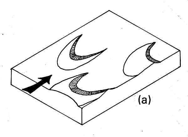
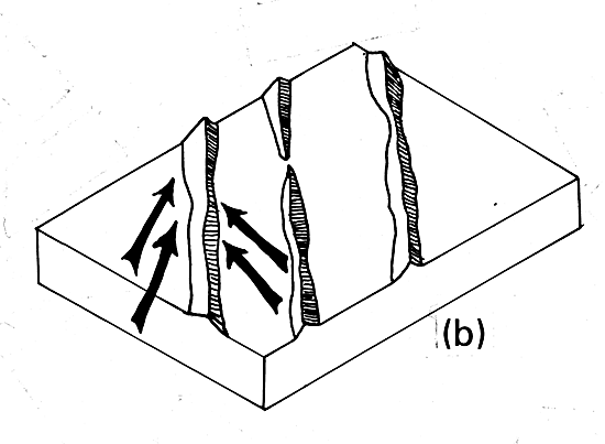
Crescentic dunes are crescent-shaped mounds or segments of ridges (Figure 8.3a). Each segment is generally wider than it is long and is bounded on its concave side by a slip face. These dunes form under dominantly unidirectional winds and are referred to as barchan, barchanoid, or transverse by some writers. At the downwind ends of crescentic dunes are horns that have no slipfaces. Crescentic dunes move faster than any other dune type. A set of dunes was measured to move an average of 100 m per year between 1954 and 1959 in Ningxia Province, China (Li, 1962), and similar rates are recorded in the Western Desert of Egypt (Embabi, 1982). Breed and Grow (1979) note that the argest crescentic dunes are in the Taklimakan Desert, where their horn-to-horn mean width is 3.24 km. Movement of such large dunes is probably so slow that it is practically imperceptible over the short run. The most common dune form on Earth and on Mars is the crescentic (Breed et al., 1979a, 1979b).
Hills (1940) described unusual 6- to 10-m high crescentic dunes on the lee shores of some of the lakes in arid Australia. These dunes are generally composed of clay, and Hills called them lunettes. Langford-Smith (1982) suggests that lunettes are formed when seasonal exposure of saline lake beds induces clay particles to combine in aggregates. The aggregates are deflated from lake beds and deposited as clay dunes that form arcuate mounds along the downwind lake shore.
Linear dunes are straight or slightly sinuous longitudinally symmetrical sand ridges typically much longer than they are wide (Figure 8.3b). Slipfaces occur alternately on both sides (Tsoar, 1978). Linear dunes cover more area in the sand seas of Earth than any other dune type, but are rare on Mars (Breed et al., 1979b). These dunes have been called seif dunes, sand ridges, or longitudinal dunes.
Linear dunes may occur as isolated ridges, but they generally form sets of parallel ridges separated by kilometers of sand, gravel, or rocky interdune corridors. The origin of linear dunes is controversial. Bagnold (1941) suggested that a change in wind direction could preferentially advance one of the horns of the crescentic dune, forming a linear dune. Many workers have noted similarities between the axial alignment of linear dunes and the prevailing direction of the regional winds. Some conclude that linear dunes are built by unidirectional winds. Other investigators, such as McKee (1979b), Lancaster (1982), Tsoar (1983), and Breed et al. (1984), provide field evidence that many linear dunes are the product of bidirectional or multidirectional wind regimes and that the long axis of each dune extends in the resultant direction of sand movement.
Most deposition on linear dunes in bidirectional wind regimes is known to occur by lee-side accretion. The effect of dominance of a wind blowing from one direction rather than the other is to concentrate erosion and deposition at the same locations on the dune. If the wind regime becomes essentially unidirectional, Lancaster (1980), suggests that a linear dune would be reformed into a series of individual or linked crescentic dunes, as may be happening in the northern parts of the Namib sand sea (Plate E-9).
Linear dunes are commonly more than 100 km long (Breed et al., 1979a). Some linear dunes have "Y" connections (Plates E-17 and E-18). Langford-Smith (1982) reports measuring a linear dune in the Simpson Desert, Australia, that was longer than 300 km.
| Figure 8.3a | Figure 8.3b | |
|---|---|---|
 |
 | |
| Figure 8.3c | Figure 8.3d | |
 |
 | |
| Figure 8.3e | ||
 | ||
Linear dunes, as well as crescentic dunes, are known to form in submarine canyons. Valentine et al, (1984) investigated 3-m high linear dunes in a canyon on the continental shelf. Those dunes have 20-cm wavelength ripples subparallel to the slope of the walls on their gentle faces. These authors find that the crests are oriented across the canyon axis.
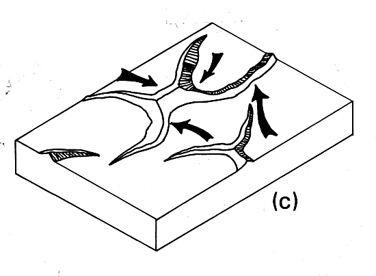
Star dunes are radially symmetrical pyramidal sand mounds with slipfaces on three or more arms that radiate the high center part of the mound (Figure 8.3c). They tend to accumulate in areas with multiwind direction and are sometimes referred to as ghords, pyramid dunes, radial dunes, or rhourds. Star dunes grow upward rather than migrate laterally. According to Breed and Grow (1979), star dunes are the dominant dunes in the Grand Erg Oriental of the Sahara (Plate E-6). In other deserts, they occur around the margins of the sand seas, particularly near topographic barriers (Breed et al., 1979a, 1984). The highest sand dunes on Earth may be the star dunes in the Badain Jaran Desert of China, which are up to 500 m tall (Zhu et al., 1980).
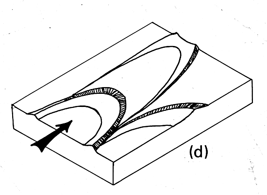
Parabolic dunes are U-shaped mounds of sand with convex noses trailed by elongated arms. The nose and the arms are bounded by slipfaces on their outer convex sides (Figure 8.3d). They are sometimes called U-shaped, blowout, or hairpin dunes and are well known in coastal deserts. These dunes form in unidirectional wind regimes, but they are opposite to the geometry of crescentic dunes in that their horns point upwind. Although their elongated arms trail behind because they have been fixed by vegetation, the bulk of the sand migrates forward. The largest parabolic dune measured by Breed and Grow (1979). is near the Colombia/Venezuela border and has a trailing arm 12 km long. Parabolic dunes are illustrated in Plate E-21, the Thar Desert.
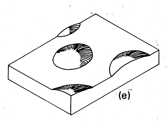
Blowout dunes are small (meter size) dunes that form downwind from deflation hollows-cup-shaped depressions or "blowouts" scooped out by wind erosion of a sand deposit. Many investigators suggest that blowouts evolve into parabolic dunes when a prevailing wind advances a section of the rim and vegetation stabilizes the arms (McKee, 1979b).Dome dunes are semicircular mounds that lack slipfaces (Figure 8-3e). Small dome-shaped dunes are normally not visible on Landsat images, but a few large dome-shaped dunes have been observed. Plate E-1 shows some dome dunes in Saudi Arabia. Bigarella (1972) discusses one 137- by 128-m dome dune that is 5.5 m high.
Reversing dunes are a variety of any of the foregoing types that may occur wherever winds periodically reverse direction. These dunes typically have major and minor slipfaces oriented in opposite directions. They tend to grow in height but migrate only slowly, if at all. McKee (1979a) considers them to be intermediate in character between a star dune and a linear dune. Breed et al. (1984) show reversing dunes that are modified crescentic dunes.
Simple, Compound, and Complex Dunes
Breed and Grow (1979), deduce that the foregoing dune types are scale-independent and occur in three forms- simple, compound, and complex. Simple dunes are basic forms with a minimum number of slipfaces that define the geometric type. They represent a wind regime that has not changed in intensity or direction since the formation of the dune. Compound dunes are large dunes on which smaller dunes of similar type and slipface orientation are superimposed. An example is a crescentic dune with smaller crescentic dunes on its gentle slope. Compound dunes probably represent a wind regime that has decreased in intensity, but not in direction, since the larger basal dune was formed. Possibly, however, the entire feature may be built by contemporaneous processes.
Complex dunes are combinations of two or more dune types. A crescentic dune with a star dune superimposed on its crest or a star dune with an arm evolving into a crescentic dune are examples of complex dunes. The most common complex dunes noted by Breed and Grow (1979), are linear or crescentic dunes with star dunes along their crests. Such complex dunes indicate that the wind regime has changed significantly with respect to intensity and direction. Understanding the parameters involved in the eolian regimes of complex dunes may provide evidence for the direction of paleoclimatic changes.
Some mineral deposits are improved, preserved, or created by geologic processes that occur as a consequence of an arid climate (Smith, 1977). Evaporation in arid lands is a process that may enrich mineral accumulation in lakes. Leaching of ore minerals and redeposition in zones near the water table may convert minerals to minable grade ore. Of the 15 major deposits in the western hemisphere strongly affected by ground water, 13 are in deserts (Smith, 1977).
Minable mineral salts concentrate in sediments and near- surface brines formed by evaporation of inland bodies of water, often during geologically recent times. The known amount of available lithium in the world, for example, nearly doubled when the mineral was found in the saline deposits in the Qaidam Basin of west-central China. Landsat views of significant evaporite deposits are illustrated in Plate E-13, the Great Basin and Mojave Deserts, and Plate E-10, the Atacama Desert.
Owing to scarcity of vegetation, arid lands are especially amenable to spectral remote sensing. Limonitic rocks have a composition that may be identified readily from Landsat Multispectral Scanner (MSS) data. By extending the wavelength range of scanners further into the infrared, additional surface materials may be identified. Using airborne spectrometer surveys of the Mojave Desert, Raines et al. (1984) discovered three previously unknown molybdenum stockworks. Field reconnaissance should determine whether these finds are economically important.
The Landsat Thematic Mapper (TM) increases the capability to detect hydrothermally altered volcanic rocks in arid and semiarid lands. Kahle (1982), recognizes the presence of hydrous minerals using data from an airborne TM simulator sensor. She points out that recognition of hydrous phases sometimes allows mapping of hydrothermal alteration zones, which is important in economic mineral exploration. Podwysocki et al., (1984) investigated altered rocks in the Mojave Desert, drawing upon data digitally processed to enhance areas of hydrothermally altered volcanic rocks. They used a color-composite image composed of three band ratios to recognize several types of altered rock on the image. These investigators found that some deposits were confused with bleached altered rocks, thus indicating the necessity for field work to investigate the significance of TM anomalies.
The world´s deserts are generally isolated, inaccessible, and inhospitable. They are also excellent laboratories in which to study all aspects of eolian geomorphology and the interaction of wind with other elements of the environment.
Modern technology and new perspectives made available by remote sensing systems are proving to be especially helpful in the effort to understand arid lands. Landsat satellites provide excellent data with which to monitor temporal variations in a given area. For example, comparing data over a period of several years may indicate changes in eolian features or an increase or decrease in productive land near the desert fringes.
One of the most exciting results of the first Shuttle Imaging Radar System (SIR-A) is that images of the Western Desert in Egypt and the Sudan show buried fluvial topography, faults, and intrusive bodies that otherwise are concealed beneath sand sheets and dunes (see Plate I-3). Most of these features are not visible in the field. The radar signal that penetrates the loose, dry, surficial sediment is being used to find previously unknown archaeologic sites and potential sources of potable water in the arid environment (McCauley et al., 1982; Schaber et al., 1986).
The high-resolution and forward overlap of the 30.5-cm focal-length lens on the Large Format Camera (LFC) allows investigators to acquire accurate to pographic data previously unavailable for poorly mapped arid lands. Using stereo LFC photos, experimental topographic profiles have been constructed for the sand sea in the Namib Desert and for the Qattara Depression of the Western Desert of Egypt (Walker, 1986). Desert color, which often reflects the composition of exposed rock surfaces and sand and which may be a significant age marker for eolian sands on a regional and a local scale, also may be investigated with the mapping- quality natural-color photographs from the LFC.
Desert studies still are hampered in many regions by lack of accurate climatic data. Most desert weather stations are in oasis surrounded by trees and buildings and have been subjected to many height and location changes throughout the duration of the station. Data from oasis do not reflect data from the raw desert. In addition, a wide variety of instrumentation has been used. Measurements are recorded over varying lengths of time and in different formats, making them difficult to interpret and compare.
To overcome some of these problems in deserts of the American Southwest, the U.S. Geological Survey (USGS) established a Desert Winds Project to uniformly measure several key meteorologic parameters of arid lands (McCauley et al., 1984). This group has successfully established geometeorologic (Geomet) stations to measure windspeeds, including peak gusts, which do most of the geologic work. The stations also measure wind direction, precipitation, humidity, soil and air temperatures, barometric pressure, and blowing dust particles at specific heights above the surface by using low-maintenance automatic solar-powered sensors. Data are sampled at 6-minute intervals and transmitted every 30 minutes to a Geostationary Operational Environmental Satellite (GOES). From GOES, the data are transmitted in real time to a receiving station and are distributed to the USGS laboratory in Flagstaff, Arizona.
These investigators have been recording weather data from four different types of deserts in Arizona and will add a Geomet site in the Chihuahua Desert in New Mexico. They have recorded a windstorm near Vicksburg, Arizona, with peak gusts of almost 144 km/hour (McCauley et al., 1984, p. 17). The investigators will combine analysis of quantitative meteorologic data acquired from the Geomet stations over several years with detailed geologic field studies and repetitive aerial and ground photographs and Landsat imagery. They will study long-term changes produced by wind in deserts of differing geologic and climatic types.
The main bodies of the world's great deserts were formed naturally by processes interacting over long periods of time. During those times, deserts expanded and shrunk independent of human activities. Evidence is abundant that large sand seas, now inactive because they are "fixed" by vegetation, once extended well beyond the present margins of core deserts, such as the Sahara. In some regions, deserts are separated sharply from the surrounding less arid areas by elevation changes that reflect structural differences in the regional geology. In other regions, the desert fringes, the transition to a more humid environment is gradational, and the desert border is difficult to define. These arid transition zones have very fragile, delicately balanced ecosystems. Hare (1983) discusses the desert fringes as a mosaic of microclimates in which small enclaves support vegetation that picks up heat from the hot winds. After rainfall, vegetation serves as a gigantic wet bulb and is distinctly cooler than its surroundings. He notes that, in areas having high livestock densities, the pounding of soil by hooves increases the proportion of fine material and reduces the percolation rate, thus encouraging wind and water erosion. Browsing by livestock and collection of firewood by man reduce or eliminate plant cover that provides good soil binding.
In these areas, and in similar semiarid environments, human activity is commonly superimposed on the natural processes that tend to shrink or expand deserts. These human activities may stress the ecosystem beyond its tolerance limit, resulting in general and semipermanent degradation of the land. This degradation of formerly productive land, referred to as desertification, is a complex process that can occur from different causes and at varying rates in different climatic regimes. Desertification may exacerbate a general climatic trend toward increasing aridity, or as some investigators propose, it may initiate local climatic change (Charney, 1975; Charney et al., 1977).
The process of desertification was first brought to world attention in the 1930s when parts of the Great Plains of the United States turned into the Dust Bowl as a result of poor farming practices initiated during a "wet" cycle. Millions were forced to abandon their farms and their livelihoods. The term was popularized by Aubreville (1949). By 1973, drought that began in 1968 in the Sahelian countries of Africa was responsible for the deaths of between 100 000 and 250 000 individuals, the disruption of millions of other lives, and the collapse of the agricultural bases of five countries. More than $200 million in cash and food were donated by private individuals, governments, and the United Nations in an effort to prevent mass starvation. Reining (1978) estimates that desertification affects more than 600 million people and one- third of the Earth´s land surface. The 1977 UN Conference on Desertification estimated that 31.6 x l06 km2 of the surface of the Earth has been subjected to desertification (Kates et al., 1977). Cross (1983) concludes that the southern edge of the Sahara has expanded by 650 000 km2 in the past 50 years.
Scientists at the Lanzhou Institute of Desert Research of the Chinese Academy of Sciences consider 170 000 km2 in China to be desertified and an additional 170 000 km2 to be in danger of desertification. They recently calculated that 50 000 km2 of formerly productive land in China has been desertified within the past 50 years owing to misuse of the land. Chinese scientists refer to deserts that they think are entirely manmade as "sandy lands." Part of the Mu Us Sandy Land (Plate E-22) falls into this category.
Desertification does not proceed in linear, easily mappable patterns. Deserts advance erratically, forming patches on their borders. Areas far from deserts may quickly degrade to barren soil, rock, or sand through lack of sound land management practices. Desert encroachment does not occur because of a change in only one measurable parameter in a given area. Rather, it is a process to which many factors contribute. Usually, an area undergoing desertification is brought to public attention only after the process is well under way. Often little or no data are available to indicate the previous state of the ecosystem or the rate of degradation.
Landsat sensors provide extensive (34 000 km2 per image) repetitive coverage of the Earth´s surface in uniform scale and in uniform format. The sensors provide data well suited for monitoring desertification. Using Landsat reflectance data, Otterman (1977) analyzed the impact of people and animals on the surface albedo of the Earth. Low albedo is a result of dark plant debris accumulating on the crusted soil surface, and a higher albedo is produced when collecting firewood and overgrazing results in a trampled, crumbled soil. Otterman believes that overgrazing has a significantly regional and global effect and may have raised the surface albedo of the Earth as much as 10 percent. Hare (1983) and Charney et al., (1977) argue that the feedback processes of albedo increase may intensify and extend drought, but may not induce permanent change.
In a review of the concept of desertification, Glantz and Orlovsky (1983) argue that the term has numerous definitions. Some researchers consider it a process of change, while other investigators view it as the end result of a process. Also, researchers are unable to agree as to where desertification can occur.
According to Glantz and Orlovsky (1983), some investigators consider climate to be the major contributor to desertification processes, with human factors contributing only a minor role. Other researchers reverse the significance, and a third group blames climate and humans equally. The importance of a long- term climatic change, when compared to a few years of fluctuating precipitation, is not yet known. Certain investigators, as summarized in Kerr (1984), suggest that drought in the American Great Plains may be related to the superposition of an 18.6-year lunar cycle of changing declination and the 22-year sunspot cycle. Some investigators consider desertification to be irreversible during a season or a few seasons, but reversible on a scale of decades or centuries.
On a local level, individuals living on desertified land may do much to reclaim the land. The wind regime near the face of dunes can be interrupted by covering the dunes with large boulders to prevent sand from blowing. In another approach, meter-size straw grids are constructed to decrease the surface wind velocity on some dunes, as is illustrated in Plate E-23 of the Tengger Desert. Shrubs and trees planted within the grids are protected by the straw until they take root. In areas where some water is available, dunes have been stabilized with shrubs planted on the lower one- third of a dune´s windward side. By decreasing the wind velocity, this vegetation prevents much of the sand from moving near the base of the dune. The higher velocity winds at the top of the dune level it off. Trees are then planted on top of the flattened dune.
Oasis and farmland in windy terrain are sometimes protected by rimming the area with specially selected grasses and shrubs. Sand that manages to pass through the grass belts is caught in the adjacent forest belts, which are strips of poplars planted 50- to 100-m apart as windbreaks. Small plots of trees may be scattered inside oasis to further stabilize the area. In China, a Green Wall is being planted in the northeast to protect the sandy lands. When complete, the Green Wall will be 5700 km long.
Efficient utilization of water resources and control of salinization are other effective tools for improving arid lands. Research is being done to exploit surface water resources, primarily seasonal runoff from adjacent highlands, to find and tap ground-water resources, and to develop effective irrigation procedures for arid lands. Other research on the reclamation of deserts is now focusing on how sand-fixing plants maybe adapted to local environments and how the resources of grazing land and water may be effectively exploited without being overused.
In a report comparing the agricultural situation in Africa and Asia, Norman (1985) notes that, although the rate of growth of food production in Asia increased by 20 percent from the 1960s to the 1970s, crop yields in Africa have not kept pace with population growth. During the 1970s, the population in Africa grew twice as fast as its food production. A new wave of desertification presently is threatening millions of people in the Sahel. According to Glantz (1980), solutions to several causes of desertification are known, but because of the political, economic, cultural, or social situation, they are not applied.
Dr. Mostafa Kamal Tolba, the Executive Director of the United Nations Environmental Programme, recently discussed the present Sahel drought (Tolba, 1984, p. 3):
"The message now is the same as it was in 1977: when we cope with desertification we can cope with drought. The difference between now and then is that now we have no excuse. The framework for applying the known remedies for desertification has existed for over six years; the suffering of the millions of poor in the semiarid regions should be on all our consciences."Continue to Plate E-1| Chapter 8 table of Contents| Return to Home Page| Complete Table of Contents|