 |
|---|
| Plate E-15 |
|
|---|
| Plate E-15 |
Evidence of eolian action on Mars was gathered first by the Mariner spacecraft series (1964-1972) and then by the two Viking Landers in 1976. Most scientists working with Mariner/Viking images refer to some eolian accumulation features on Mars as desert drifts rather than dunes because they appear to be remnants of formerly more expansive deposits. The constituent particles are probably silt- and clay-sized rather than sand-sized. Sharp and Malin (1984), however, argue for the presence of significant sand-sized particles on the surface. The features on Mars appear to be stabilized erosional remnants of a formerly more extensive cover rather than growing and moving sand dunes (Mutch and Jones, 1978).
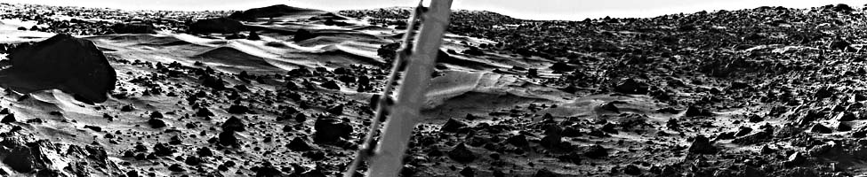
Viking Lander 1 touched down on Chryse Planitia, Mars, on July 20, 1976, at the locality since designated the Thomas A. Mutch Memorial Station. This Plate image, acquired at 7:30 a.m. martian local time by the Viking Lander scanner, shows a ground panorama that covers about 1000, looking northeast on the left to southeast on the right. The Viking Lander 1 meteorology boom of a miniature weather station is in the center of the image. An eolian accumulation zone occupies the far left and an eolian deflation zone the right. This duality is similar to that of many deserts on Earth. The large boulder at the left is about 8 m from the lander and measures about 3 by 1 m. As seen in images of this boulder at higher Sun angles, it actually consists of two coarse- grained and banded boulders, leading to the suggestion reported in Mutch and Jones (1978) that it may be an impact breccia. Other Viking images indicate that the boulder, nicknamed "Big Joe" by Viking investigators, is capped with fine- grained material, possibly a remnant of dust that may have covered the entire area (Mutch and Jones, 1978).
| Figure E-15.1 | Figure E-15.2 |
|---|---|
 |
 |
Internal stratification of the drifts seen to the left of the boom and in the three ridges in the drift right-center of the boom suggest a number of depositional events. Mutch and Jones (1978) note that the most recent event is general erosion because the drifts in the Plate are well wind-scoured. Examining multitemporal data, these authors conclude that the apparently bright drifts in this Plate are actually dark drifts with a thin veneer of bright fine-grained dust.
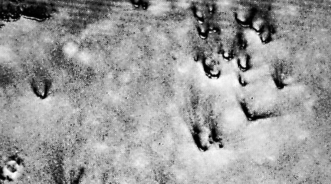
The martian surface at the Mutch Memorial Station and at the Lander 2 site is peppered with angular blocks of many sizes. On close inspection, most of these rocks have small cavities that may be flutes created by scouring by sediment-laden current. They provide strong evidence of the importance of eolian activity on Mars (Garvin et al., 1981).
As the two Viking Landers collected surface and atmospheric data on the Martian surface, their companion Viking Orbiters collected images. The Viking Orbiter 1 periapsis of 300 km above the surface provided highest resolution images and shows features as small as 20 m.
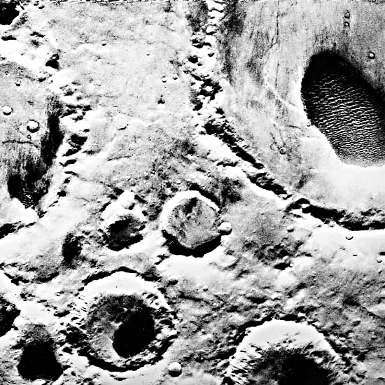
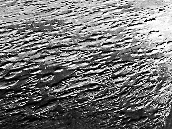
The dune fields arise from global wind patterns that result in erosion of the equatorial and midlatitude regions and deposition in the circumpolar regions. Sand seas of varying size on Mars are most common in the north circumpolar areas. Mars also has numerous small crater-floor dune fields (McCauley, 1973; Tsoar et al., 1979; Breed et al., 1979b). Figure E-15.1 shows several crater-floor dune fields. The dune field in the large crater on the upper right is 65 km long by 30 km wide. The streaks in this sand sea and along the edge of the crater to its left imply a wind from the east. According to Breed et al. (1979b), this bed-form pattern of massed crescentic dune ridges is typical of most crater-floor dune fields. Some of the crescentic dunes in Figure E-15.2 are more than 1 km wide. The asymmetry of the horns, with an elongated western horn, suggest a different secondary wind direction for these hooked crescentic dunes. The dark material that streaks from the horns may be dust recently blown from the dunes.
| Figure E-15.3 | Figure E-15.4 |
|---|---|
 |
 |
When comparing the scale ratios derived from measurements of width, length, and wavelength of crescentic dunes on Mars, Breed et al. (1979b) find that the circumpolar dunes are nearly identical in shape to the crater-floor dunes although the former are half their size. They suggest that the two dune areas are in dynamic equilibrium with depositional environments in widely separated areas on Mars. These authors propose that on Mars, as well as on Earth, dune patterns are topographically controlled.
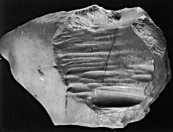
Many investigators consider the Western Desert of Egypt, one of the most arid regions on Earth, to be a terrestrial analog to the surface of Mars (McCauley et al., 1979). Maxwell and El-Baz (1982) find dark streamlined streaks in orbital images of this desert similar in scale and form to streaks on the martian surface. They believe that the extreme aridity of southwestern Egypt makes it a martian analog both on the scale of orbital images and on the scale of millimeter-size rock pits.
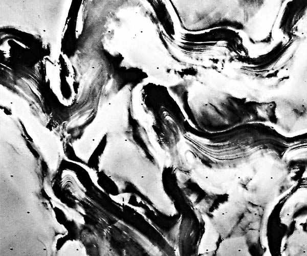
Figure E-15.3 is a siliceous limestone ventifact from the Western Desert of Egypt. The arrow indicates the wind direction. Whitney (personal communication, 1985) notes that the subsidiary flow patterns beneath the main flow lines of wind deliver the abrasives to surfaces to shape and flute ventifacts. Figure E-15.4, also of the Western Desert, is a series of yardangs in siliceous limestone. These ventifacts and yardangs bear a striking resemblance to the fluted and pitted rocks imaged by the Viking Landers (McCauley et al., 1979). Whitney (1983) notes that the response of the wind to the shape of the feature on which it impinges is a significant factor in developing streamlined forms.
| Figure E-15.5 | Figure E-15.6 |
|---|---|
 |
 |
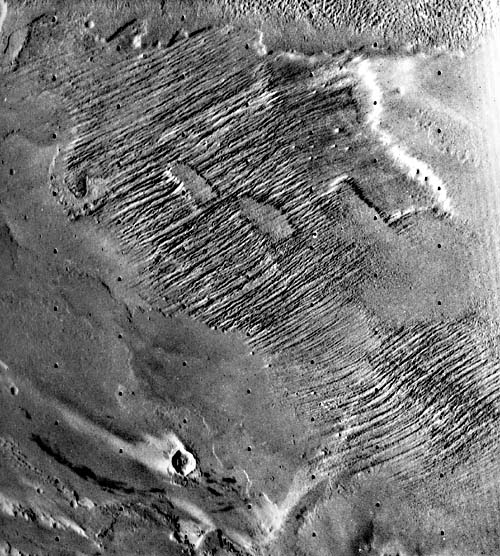
Ward (1979) suggests that the 50-km long, l-km wide, and 200-m high ridges in the left of Figure E-15.5 are early- stage yardangs. They have deep wide troughs, but the ridges are not streamlined. He notes that these yardangs are oriented with their widest ends toward the east, indicating that the wind effectively came from that direction. Compare this high- resolution (20-m) image of martian yardangs with the 80- m resolution MSS image of the yardangs of the Lut Desert (Plate E-19).
Figure E-15.6 illustrates deposits of alternating layered ice and windblown dust near the north polar cap. According to Howard et al. (1982), layered deposits accumulate on the flat uplands and on the banded terrain of pole-facing trough walls. Erosion of pole-facing scarps (those facing upper left) expose layers previously deposited. Analysis of multitemporal data of martian polar stratigraphy suggests that annual and other periodic climatic changes due to orbit fluctuations occur on Mars (Howard et al., 1982). Viking 11A097, August 3. 1976.
Continue to Plate E-16| Chapter 8 Table of Contents.| Return to Home Page| Complete Table of Contents