 |
 |
|---|---|
| Plate E-24 | Map |
|
|
|---|---|
| Plate E-24 | Map |
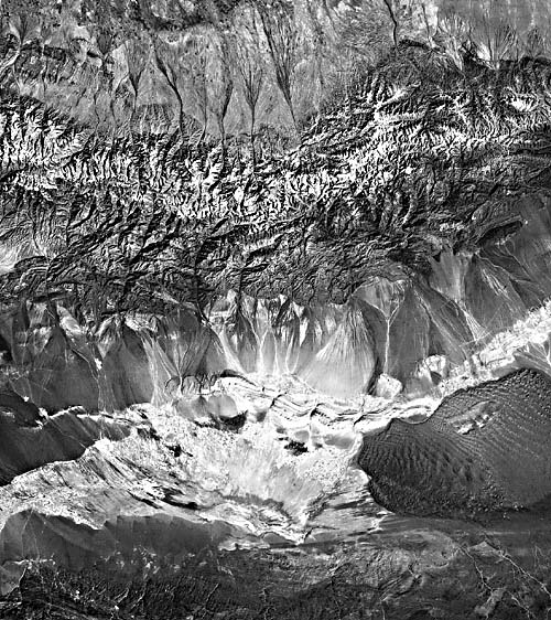
The Turpan Depression is a 50 000-km2 fault- formed interior drainage basin in Xinjiang Autonomous Region, People´s Republic of China. The basin is bounded by the Tian Shan (Celestial Mountains), which are composed predominantly of quartzite and other metasediments. A small segment of the range south of the depression is seen at the bottom of this Plate, and the glaciated north range is above the center. The mountain topography creates a rain-shadow desert in the Turpan Depression. The windward north side of the Tian Shan has more ice, rain, and vegetation than the depression of the range. Drainage channels are evident on the alluvial plain of the northern slopes, where glacial meltwater flows into the Junggar Basin.
Wind flows through gaps in the Tian Shan to the northea st and northwest of the depression. Much of the depression is a deflation zone composed of black gobi (regionally unsorted loose subangular to subrounded quartzite gravels) occupying an area 25 km wide in the north and 15 km wide in the south. The dark gravel desert dominates much of this Plate. Alluvium, artesian wells, spring-fed oases, and small lakes occupy the center of the basin. The maximum recorded ground temperature in the depression is 48.9°C (Xia and Hu, 1978).
Fifty years ago, winds with speeds greater than 36 m/sec carried sands that totally buried all the houses in the area of the Five Star People´s Commune, and in 1961, a similar storm destroyed the entire wheat crop. To stop disasters such as these, the Chinese construct shield belts to reduce the wind velocity over the farm land.
| Figure E-24.1 | Figure E-24.2 |
|---|---|
 |
 |
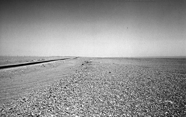
The Huang Liu He State Farm in the northwestern part of the depression was begun in 1957 on gobi terrain 8 km south of the Turpan Railroad Station. Water is supplied by wells and by karez-horizontal underground tunnels that carry water from the Tian Shan into the depression. If the water were not shielded from the dry atmosphere, it would quickly evaporate. Wheat, sorghum, cotton, watermelon, grapes, and various vegetables grow on the farm.
Figure E-24.1, looking north toward the Huang Liu He State Farm, is an example of the deflated gobi area. Note the flatness and equigranular pebbles. The farm is conspicuous in Figure E-24.2, the second principal component of digital data for this scene. Principal component analysis is designed to minimize the correlation among the Landsat bands. The second principal component emphasizes vegetation (Lodwick, 1979). The dark patch in the left center of the figure represents vegetation evident on the farm; the dark area at bottom right marks the oases in the center of the depression. In comparing this October 1972 image with an October 1980 Landsat image, a 12 percent increase in the productive area of the farm was noted (Walker and Liu, 1982).
| Figure E-24.3 |
|---|
 |
An intermittent salt lake in the southern part of the basin, Aydingkol Hu, is difficult to locate on this image. The lake is the second lowest point on the surface of the Earth not covered by ocean (-154 m), and its location is represented by a dot on the map.
Much of the sand in the depression has been transported to Sand Mountain, a 2500-km2 sand sea. The dune pattern in the sea reflects the atmospheric circulation pattern of the area. Masibroda (1952) notes that the northwest and north do not penetrate far onto the sea and that the northeast winds become considerably intensified and prevail over the area. The linear array of the complex linear dunes and sand sheets on the sea reflect the complex patterns described by Masibroda. Star dunes appear in the south center of the sand sea and dominate the northeast.
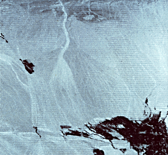
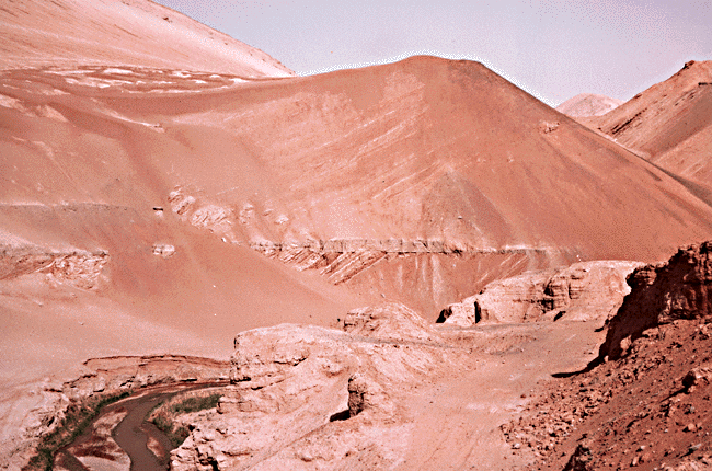
Flaming Hills (Figure E-24.3) is an anticlinal structure of Mesozoic and Cenozoic sandstone, conglomerate, and mudstone. This figure illustrates poorly consolidated sand dunes that were buried by water. The lake eroded the crests of the dunes and deposited a horizontal layer of siltstone above the sand. Following evaporation of the lake, dunes encroached and were deposited above the lake sediment (C. Breed, USGS, oral communication, 1982). More recently, fluvial erosion has exposed the section. Note that the dip of the cross-strata below the horizontal beds is slightly steeper than that of the strata above the bed. Landsat 10073-04181-7, October 4, 1972.
Continue to Plate E-25| Chapter 8 Table of Contents.| Return to Home Page| Complete Table of Contents