 |
 |
|---|---|
| Plate E-6 | Map |
|
|
|---|---|
| Plate E-6 | Map |
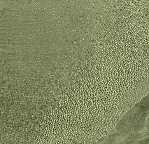
Grand Erg Oriental is a 192 000-km2 sand sea east of Grand Erg Occidental in the central Sahara. The two sand seas are separated by 100 km of gravel desert. About 70 percent of Grand Erg Oriental is sand covered (Wilson, 1973).
A section of Tinrhert Hamada is visible beyond the southeast margin of Grand Erg Oriental. A few intermittent drainage channels mark the extension of streams that flow from the hamada into the sand sea. The light areas on the hamada are saline. Breed et al. (1979a) conclude that the abrupt southern boundary of the sand sea may be controlled topographically because the margin matches the 306-m contour line of the plateau slope. As Wilson (1973) notes, ergs are confined to basins and terminate at any pronounced break of slope.
The star dunes at the boundary appear much closer together and smaller than the dunes directly north in the sand sea. Star dunes are common in the northern Sahara. According to Wilson (1971, 1973), the isolated star dunes of the Grand Erg Oriental are not randomly distributed, but form at the nodes of crossing dune trends. The wind regime of Grand Erg Oriental is very complex, involving the northeast summer trade winds, temperate- zone and southwesterlies, northwesterly cyclonic winds, local thermal winds, and winds related to the sand seas, mountains, and massifs (Wilson, 1971). Wilson states that, although the wind regime is complex, resultant direction of sand flow is definite. He finds dunes without slipfaces in the coarser-grained interdune hollows. Breed et al. (1979a) trace the sand-passing dune trends westward into the Grand Erg Occidental, where the star dunes merge into complex linear dune chains.
| Figure E-6.1 | Figure E-6.2 |
|---|---|
 |
 |
The elevation decreases about 150 m from the border of the sand sea with the hamada to the upper left of this image. With decreasing elevations, the star dunes become isolated and smaller. The interdunal spacing increases significantly. A tendency toward a slight east-west linear orientation becomes apparent in the upper left of the Plate where sand sheets dominate.
Breed et al. (1979a) measure the isolated star dunes and find a mean diameter between 0.7 km at the northern upwind side to 1.7 km at the southern margin just west of this image. The mean crest-to-crest distance ranges from 0.8 to 6.7 km in the north to from 1.5 to 3.1 km in the south.
Wilson (1973) suggests that the sand is derived from deflation of alluvium from basins upwind of the sand sea. He estimates a net sand inflow of about six million tons annually for this sand sea. Based on a mean dune height of 117 m and a mean spreadout sand thickness of about 26 m, he infers that Grand Erg Oriental has had an active sand-blowing life of 1 350 000 years.
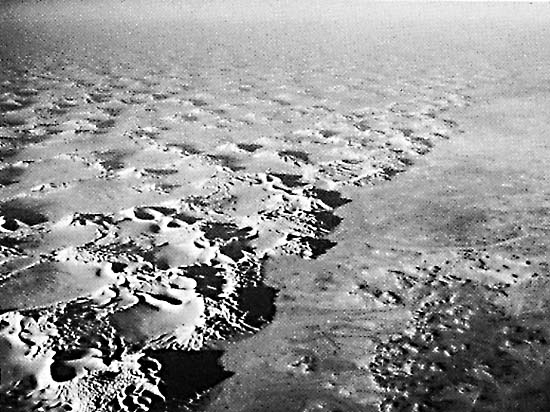
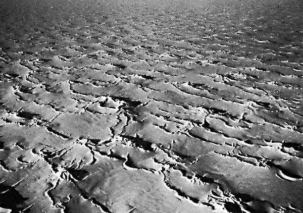
Figure E-6.1 and Figure E-6.2 are aerial photographs of Grand Erg Oriental. Tinrhert Hamada is in the right foreground of Figure E-6.1. The compound star dunes at the border are larger and closer together than the dunes within the sand sea, as can be seen on the Plate. Figure E-6.2 shows complex linear dunes just inside the southern border of the sea. Although most of the dunes are linear, a few star dunes maybe seen in the left center of the photograph.
| Figure E-6.3 |
|---|
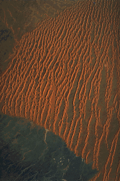 |
Figure E-6.3 is a Space Shuttle photograph of the erg a little southwest of the Landsat Plate image. Many of the linear star dunes in that photograph cross the bulk of the sand sea. The interdunal sand areas do not appear to be thick, and the boundary between the sand sea and the hamada is distinguished easily. Landsat 1199-09323-7, February 7, 1973.
Continue to Plate E-7| Chapter 8 Table of Contents.| Return to Home Page| Complete Table of Contents