 |
 |
|---|---|
| Plate G-14 | Map |
|
|
|---|---|
| Plate G-14 | Map |
A fjord is "a long narrow winding inlet or arm of the sea, U-shaped and steep-walled, generally several hundred meters deep, between high rocky cliffs or slopes along a mountainous coast; typically with a shallow sill or threshold of solid rock or earth material submerged near its mouth and becoming deeper inland." A fjord usually represents the seaward end of a deeply excavated glacial-trough valley that is partially [sic, further] submerged after the melting of the ice. Examples: along the glaciated coasts of [Chile, Iceland, British Columbia, New Zealand] Alaska, Greenland, and Norway" (Bates and Jackson, 1980). It should be emphasized that the ice stream which formed the fjord had already eroded the valley far below sea level and that the sea simply occupies this vacated glacial trough.
In the previous two Plates, various landforms associated with glacial erosion, which can be delineated on Landsat images, have been discussed: cirques, arêtes, glacial troughs, hanging valleys, and fjords. In the following discussion of the fjord landform, one should keep in mind that the cirque, glacial trough or U-shaped valley, hanging valley, and fjord are really only variations on the same theme and, in glaciated coastal areas, generally occur together (Plate G-13). A cirque is a bowl-shaped feature in a mountain ridge; a U-shaped valley or glacial trough is an erosional modification of a preexisting valley by a valley glacier originating in a cirque, an outlet glacier originating from an ice cap, or an ice stream originating from an ice sheet; and a fjord is a flooded glacial trough in a coastal region (Grosval'd and Glazovskiy, 1984).
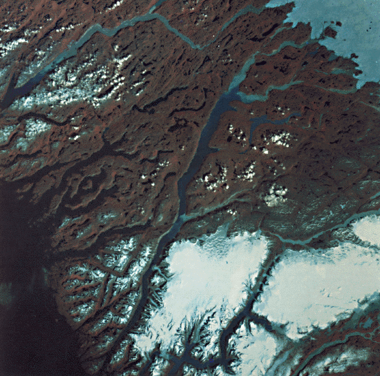
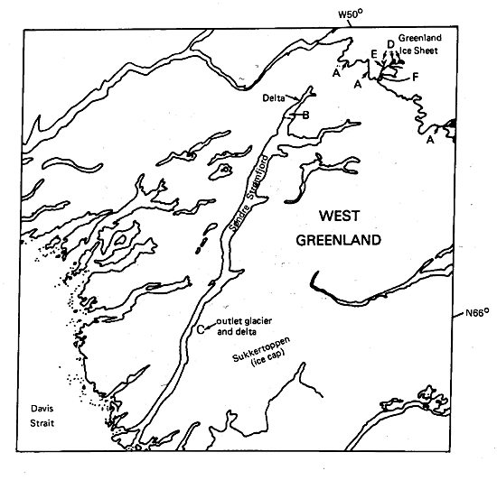
This Plate is a false-color composite Landsat image of Søndre Strømfjord, one of the longest fjords in Greenland. Søndre Strømfjord extends for approximately 160 km in a northeasterly direction from its mouth at Davis Strait to the glacial delta at its head. The delta (B) is slowly infilling the fjord from glacial sediment derived from the Greenland Ice Sheet, the edge of which can be seen in the eastern part of the image.
| Figure G-14.1 | Figure G-14.2 |
|---|---|
 |
 |
It is likely that Søndre Strømfjord owes its location to a preexisting valley that had formed along a structural feature, such as a fault. In fact, structural (fracture-pattern) control of the fjords, lake basins, and glaciofluvial valleys is clearly evident on the Plate image because of their preferred orientations to the east or northeast. From the head and extending for about 90 km in a southwesterly direction, the fjord cuts across granodioritic gneisses (Escher, 1970; Escher and Watt, 1976). Glaciofluvial deposits occur from the edge of the Greenland Ice Sheet (A) across the delta (B) at the head of the fjord. Except for occasional marine deposits in the tributary valleys, the walls of the fjord are bare bedrock (Weidick, n:d.). Also at the edge of the ice sheet, three nunataks (D), medial moraines (E), and the terminal moraine (F) can be easily delineated.
During the Pleistocene, Søndre Strømfjord was once occupied by a fast-flowing ice stream within the main Greenland Ice Sheet that reached to the present coast and beyond. Sukkertoppen ice cap on the south would have coalesced into the main ice sheet and contributed part of its outflow down the present fjord during that time. A few of the outlet glaciers from the northwestern margin of Sukkertoppen extend toward the fjord, with the longest outlet glacier building a delta into the fjord at (C). A good modern analog to the setting of the Søndre Strømfjord ice stream during the Pleistocene is shown in Plate G-3, a Landsat image of the Jakobshavns Isbrae and ice stream. At the beginning of the Holocene (about 10 000 years B.P.), as the great ice sheets of the Pleistocene continued to melt away rapidly, sea level was approximately 75 m lower than at present. In western Greenland, sea level rose to inundate coastal areas before the land experienced delayed isostatic rebound from the loss of ice along the coastal margin. Crustal rebound produced reemergence of the land, so the relationship between sea level and the land has been complex during the last 10 millennia. The present sea level has further inundated the glacial trough of Søndre Strømfjord, thereby creating a spectacular long fjord. Most fjords are quite deep and represent substantial glacial erosion or bedrock well below present or even Pleistocene sea levels. The deepest known fjord, more than 2000 m below sea level, is in Antarctica. Sognefjord, Norway, has a maximum depth of 1308 m (Embleton and King, 1975a).
| Figure G-14.3 |
|---|
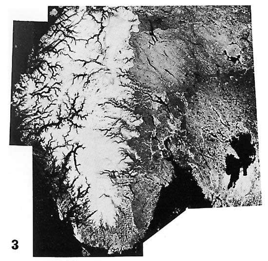 |
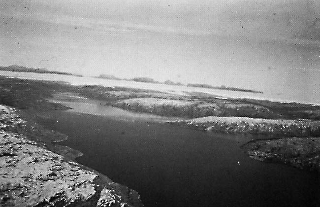
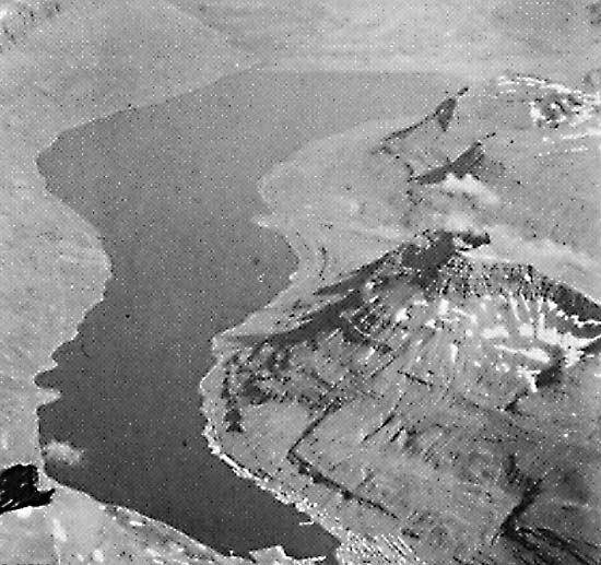
Figure G-14.1 is an aerial view of Søndre Strømfjord, about 120 km inland from its mouth, looking northeast along the fjord toward the head of the fjord, with the edge of the Greenland Ice Sheet visible about 70 km in the distant background. A layer of clouds lies just above the horizon. Figure G-14.2 is an aerial oblique view of a 20-km long fjord, Seydisfjördur, on the east coast of Iceland, which cuts through Tertiary plateau basalts. A hanging cirque is visible high up on the valley side east of the town of Seydisfjördur at the head of the fjord. The relief between the crests of the ridges and the bottom of the fjord is about 1000 m. Figure G-14.3 is a Landsat image mosaic of southern Norway and part of Sweden showing the classic region of fjords along the coast of Norway. The regional fracture patterns exercise a marked control on the orientation of fjords. The fjords are enhanced on the Landsat image because of residual snow cover in the highlands during May-June, 1973. Landsat 21654-14185, August 3, 1979.
Continue to Plate G-15| Chapter 9 Table of Contents.| Return to Home Page| Complete Table of Contents|