 |
 |
|---|---|
| Plate G-17 | Map |
|
|
|---|---|
| Plate G-17 | Map |
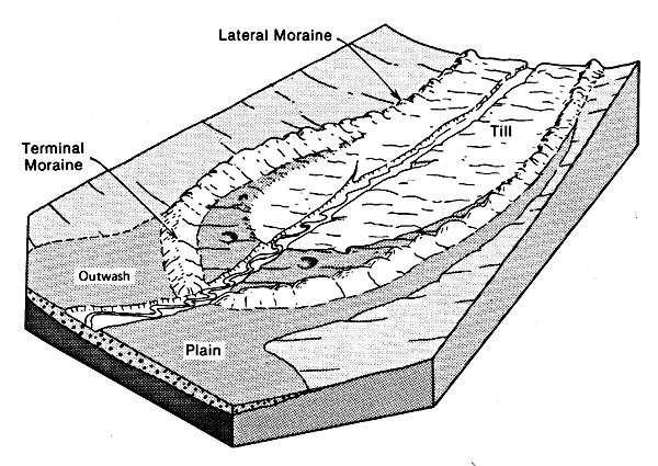
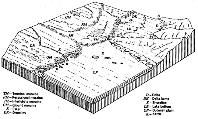
Ritter (1978) classifies morainal landforms into three basic groups (see Table 9-6): end moraines, including terminal (Plate G-15), lateral (Plate G-16), and recessional (Plate G-15); interior and minor varieties (medial, washboard, and interlobate (Plates G-15 and G-16); and till. Bates and Jackson (1980) define till as "dominantly unsorted and unstratified drift, generally unconsolidated, deposited directly by and underneath a glacier without subsequent reworking by meltwater, and consisting of a heterogeneous mixture of clay, silt, sand, gravel, and boulders ranging widely in size and shape;" and define ground moraine (Figures 9-21 and 9-22a) as "an accumulation of till after it has been deposited or released from the ice during ablation, to form an extensive area of low relief devoid of transverse linear elements."
The "gently rolling surface" of till-covered (ground moraine-covered) terrain is often characterized by numerous glacial lakes. Thornbury (1954) noted that: "It is undoubtedly true that glaciation has been responsible for the formation of more lakes than all other geomorphic processes combined."
| Figure G-17.1 | Figure G-17.2 |
|---|---|
 |
 |
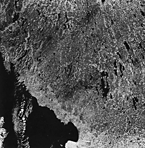
This Plate is a Landsat image of a glaciated area in southwestern Sweden showing the numerous glacial lakes that have been created mainly by depositional processes associated with the recession of the Late Weichselian (Wisconsinan) ice sheet (Rudberg, 1984). Bolmen and Mockeln are two of the larger lakes (Lundquist et al., 1958). This glaciated region was one of the first Landsat-imaged areas to be investigated by an interdisciplinary group of Nordic scientists (Svensson et al., 1973).
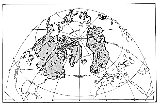
Most of the region encompassed by the image is underlain by gneisses and granites (Magnusson et al., 1958). It is across this mainly granitic and gneissic bedrock that repeated advances and recessions of the Pleistocene Scandinavian ice sheets passed (see Figure 9-l), alternately eroding and depositing great quantities of glacial sediments (Rudberg, 1984).
In this part of Sweden, the ice sheet was between 2000 and 2500 m thick during its maximum extent at about 20 000 years B.P. (Hughes et al., 1981). On the southern part of the west coast of Sweden, end moraines have radiocarbon dates of about 13 000 years B.P. (Andersen, 1981). Since the ice-front deposits (Taberg-Levene) at the southwestern end of Lake Vättern have been radiocarbon dated at about 12 000 years B.P., the entire region encompassed by the Landsat image was deglaciated from south-southwest to north-northwest in about 1000 years (Andersen, 1981).
In the waning stages of the last great Scandinavian Ice Sheet-the Weichselian-as the ice-sheet margin retreated across the area, an assortment of glacial deposits and landforms were laid down (Duphorn et al., 1970). According to Lundquist (1981), the area of the image lies within three morainal zones: on the west and northwest, on the south, and on the east and northeast. "On the west coast an end moraine zone of active, possibly cold-based ice, passes eastwards into a zone of ridges formed at the stagnancy of a formerly active, cold-based ice," and "a zone of subglacial features formed by active, warm-based ice."
| Figure G-17.3 |
|---|
 |
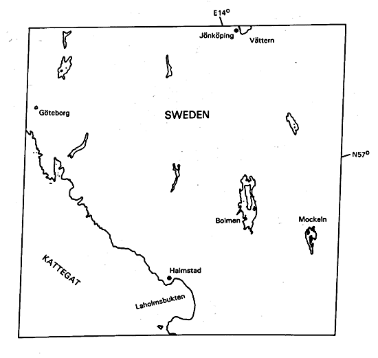
Most of the region included in the image is covered by till (ground moraine), drumlins, drumlinoid (Rogen) moraines, and linear glaciofluvial deposits such as eskers (Persson, 1972). However, around the bay at Laholmsbukten and extending northwest along the coast in a narrow band are marine deposits that have been uplifted by the rebound of the Fennoscandian shield in response to removal of the ice sheet. Throughout the area are limited exposures of bedrock. Larger bedrock outcrops occur on the west coast of Sweden from a point about half way between Laholmsbukten and the city of Göteborg.
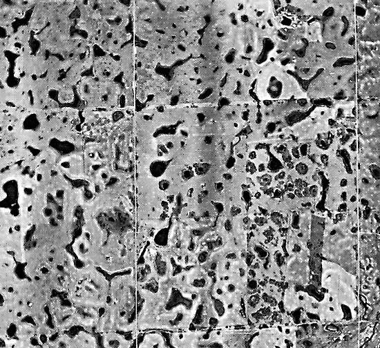
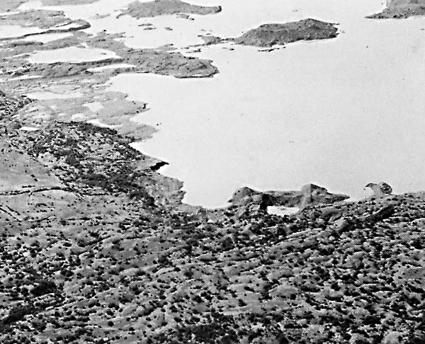
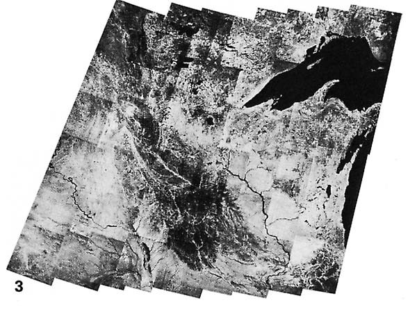
Vast areas of the mid-continent of the northern United States and large areas of Canada are covered by till (ground moraine). Figure G-17.1 is a vertical aerial photograph of an area of hummocky till (ground moraine) in the province of Saskatchewan, Canada. Slaney (1981) has a brief section on glacial features in Canada that are visible on the various Landsat images included in his book; hummocky till (ground moraine) is delineated on five of these images. Figure G-17.2 is an oblique aerial photograph of ground moraine that has become visible following recession of the terminus of the Malaspina Glacier, a piedmont glacier (see Plate G-7) in Alaska. A proglacial lake with small morainal ridges is visible in the background. Figure G-17.3 is a Landsat mosaic of till (ground moraine) associated with the Des Moines lobe of the Laurentide Ice Sheet in north-central United States (see Figure 9-1) (Lucas and Taranik, 1977). The pronounced pattern of terminal and recessional moraines grades into till (ground moraine) to the northwest with the appearance of numerous glacial lakes. Landsat 1041-09464-7, September 2, 1972.
Continue to Plate G-18| Chapter 9 Table of Contents.| Return to Home Page| Complete Table of Contents|