 |
 |
|---|---|
| Plate G-6 | Map |
|
|
|---|---|
| Plate G-6 | Map |
An outlet glacier can be defined as "a valley glacier which drains an inland ice sheet or ice cap and flows through a gap in peripheral mountains" (Armstrong et al., 1973). Outlet glaciers also include broad well-defined lobes of glacier ice that protrude from an ice cap or inland ice sheet and spread over areas of low relief.
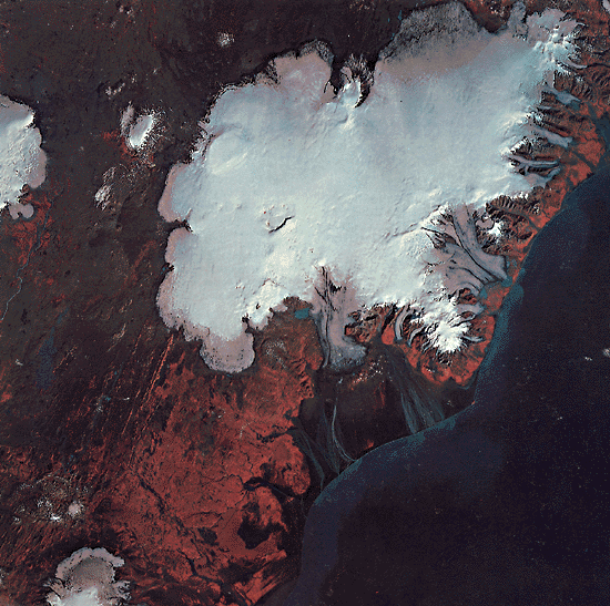
Inland ice sheets, such as those of Greenland and Antarctica, have numerous outlet glaciers around their margins. Ice caps may have no outlet glaciers, such as the small ice cap on Ok in west-central Iceland, or may have a great many, such as the Vatnajökull ice cap in southeastern Iceland. Plate G-6 is a Landsat MSS false-color composite image of Iceland´s largest ice cap, Vatnajökull (Williams et al., 1977), and the surrounding area including part of the Hofsjökull (upper left) and Myrdalsjökull (bottom left) ice caps and all of the Tungnafellsjökull ice cap (small one between Vatnajökull and Hofsjökull) (from Williams, 1983c). At 8300 km2 (area calculated from this September 22, 1973, image), Vatnajökull is the largest of Iceland´s 13 principal ice caps. It is a complex ice cap with 43 named outlet glaciers, either of the valley glacier type (especially prominent on the eastern, more mountainous part of Vatnajökull) or of the lobate type (more typical of the western part of Vatnajökull). The digitally enhanced Plate image captures far more glaciological features than are evident on the standard false-color composite image. The latter was made into an image map by the U.S. Geological Survey (1976b).
| Figure G-6.1 | FigG-6.2 |
|---|---|
 |
 |
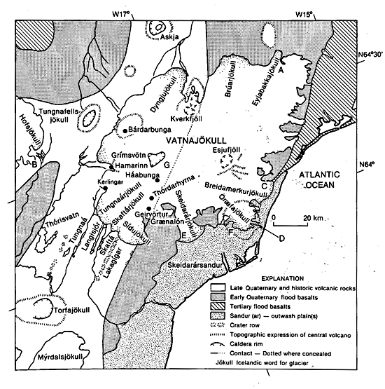
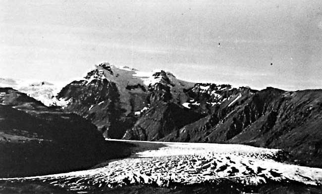
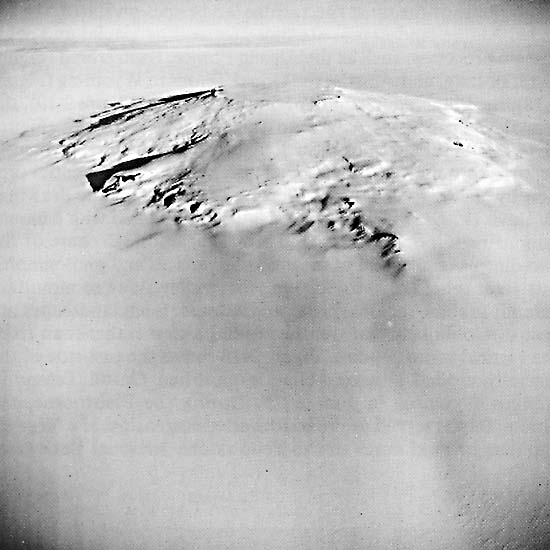
The index map shows some of the principal geographic, glaciological, and geological features associated with Vatnajökull and surrounding areas (Williams, 1976; Williams et al., 1974, 1975). This map also serves as a reference map for other types of glaciers and landforms associated with glaciers that are discussed in this chapter: the surging glacier, Eyjabakkajökull (A) (Plate G-10); the accumulation/ablation zone of a glacier (Figures 9-5 through 9-9) terminal and recessional moraines associated with Múlajökull (Figure G-15.1), one of the outlet glaciers from Hofsjökull; medial moraine at Breidamerkurjökull (C) (Plate G-16) lateral moraine at Kvíërjökull (D) (also Plate G-16); and outwash plain (including proglacial and ice-dammed lakes associated with the glacier, Skeidarárjökull (E) (Plate G-22). A sequence of Landsat images of Skeidarárjökull enabled a "time-lapse" calculation of its average velocity as 2 m per day over an 11-month interval (Williams et al., 1979). Figure G-6.1 is an oblique aerial photograph of Svínafellsjökull (F) one of Vatnajökull´s 43 named outlet glaciers. Svínafellsjökull originates in the higher elevations of the glacier-capped stratovolcano, Öraefajökull, then descends to the Skeidarársandur outwash plain (Plate G-22) through a valley. In its lower reaches, it is indistinguishable from a valley glacier (Plate G-9). The crevassed terminus abuts a hummocky and complex series of terminal moraines in the foreground. The outermost terminal moraine, Stóralda, is considered by Thorarinsson (1956a) to have formed about 600 B.C. (See Plate G-16 for a Landsat-3 RBV image of this outlet glacier and others on the eastern margin of Vatnajökull.)
The western part of Vatnajökull has several sites of volcanic and geothermal activity. Grímsvötn ((G) on index map of Plate G-6) is a 30-km2 subglacial volcano (see also Plate G-15 and Figure 9-14), the site of volcanic activity in 1934 and in 1983 (see also Figure 9-16 for dormant subglacial volcanoes in Antarctica). Kverkfjöll and Thórdarhyrna have also been sites of historic volcanic activity. Two collapse cauldrons, the result of subglacial geothermal activity, can be seen to the west of the Grímsvötn caldera (between Grímsvötn and Hamarinn) (Thorarinsson et al., 1974; Williams and Thorarinsson, 1974). These collapse cauldrons are even better delineated on a wintertime image of Vatnajökull (Plate G-15) (U.S. Geological Survey, 1977).
| Figure G-6.3 |
|---|
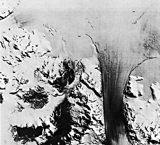 |
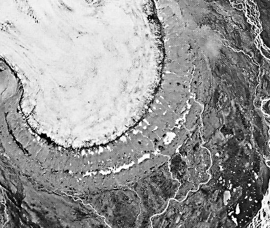
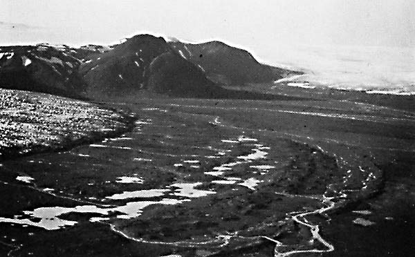
Figure G-6.2 is a vertical aerial photograph of Múlajökull, an outlet glacier from the Hofsjökull ice cap in central Iceland. Note the transverse and longitudinal crevasse patterns up-glacier from the terminus, the result of stress in the ice as Múlajökull splays out in a near- piedmont glacier after it emerges from confinement in the valley (see Plate G-6). The concentric recessional moraines are shown in Figure G-15.1. Between the terminus and the innermost recessional moraine is till, probably including some buried dead ice, with many glacial and proglacial lakes. Figure G-6.3 is a Landsat image of the mouth of the Byrd Glacier, Antarctica, the Earth´s largest outlet glacier in terms of discharge. The image shows the glacier as it crosses the Transantarctic Mountains to merge with the western edge of the Ross Ice Shelf. Landsat 1426-12070, September 22, 1973.
Continue to Plate G-7| Chapter 9 Table of Contents.| Return to Home Page| Complete Table of Contents|