
History of Remote Sensing: A Landsat Image
The picture below is a Landsat full image, from October 1972, shown both as individual bands and as a false color composite. We display below a succession of MSS bands 4 through 7 (bands 1-3 were assigned to the RBV), comprising images of a very well known region in the eastern U.S. Beneath these four images, is a false color composite, made from bands 4, 5, and 7, of this scene, here extended southward to include the southern tip of a peninsula that includes the town of Cape May ( a clue). Before continuing, we recommend trying to discern what geographic area we show here.
Note 1: By convention, Landsat and most other satellite system images are normally oriented with North towards the top. However, because of the ninety-eight degree orbital inclination, the north direction is not vertical but is a few degrees inclined relative to the perpendicular to the top and bottom margins of the printed image.
Note 2: The lettering at the bottom of each image probably not readable on your screen is the standard annotation placed on Landsat images produced at NASA, EROS, and most commercial facilities The information recorded, from left to right, includes the calendar date of acquisition, the latitude-longitude coordinates of the scene principal and nadir points, the sensor type, the elevation and azimuth positions of the Sun, and the Scene (Frame) identification number (I.D.) starting with the particular Landsat (1 through 5) and ending with the specific band (or band combination if in color).
MSS Band 4 MSS Band 5 MSS Band 6 MSS Band 7 MSS Band 4 = Blue MSS Band 5 = Green MSS Band 7 = Red
.
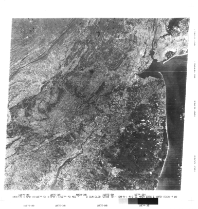
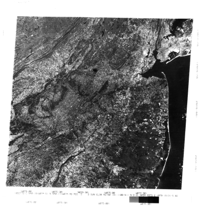
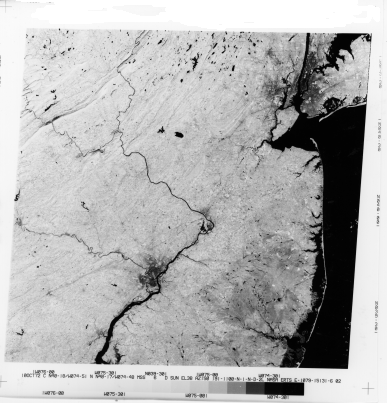
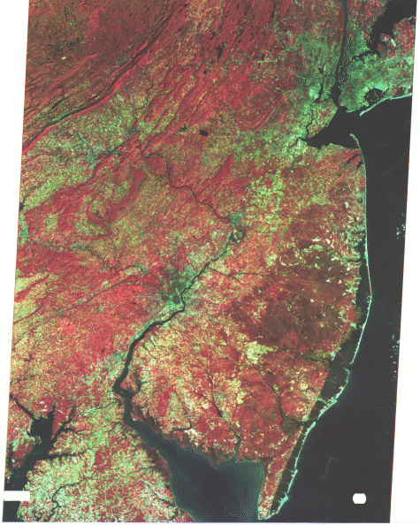
If you correctly identified the scene, then in the individual bands, you saw much of New Jersey along with New York City and the west end of Long Island in the upper right corner and Philadelphia at bottom left center. The color composite extends the coverage to the northern Delmarva Peninsula, flanked by the northern Chesapeake Bay (bottom left) and Delaware Bay (bottom center) and Cape May (bottom right). These two urban regions, along New Jersey cities along the Hudson River, appear in light to medium gray tones in Band 5 (red). In Band 7 (IR), the central areas of these metropolitan complexes are in dark tones, owing largely to the prevalence of asphalt streets and dark (usually asphalt) roofs, together with few trees and little other vegetation. The urban scene contrasts with the to light tones associated with vegetation in the countryside. Water is dark in Bands 6 and 7 but lighter in Bands 4 and 5, in part because of silt and other sediments (more reflective). In contrast, among the brightest features in both individual-band and color composite scenes are the sandy beaches and soils comprising the ocean side of the barrier islands lining the New Jersey coast. Vegetation in this October 10. 1972 scene is still actively growing (mostly green, but some trees are beginning to get their autumn colors), so its spectral distribution indicates an overall brightness in the Band 6 and 7 images We can compare the dark tones of the fold belt ridges in the upper left in Band 5 with their corresponding light tones in Band 7. Surfaces dominated by vegetation are shown in several shades of red in the false color composite. Harvested (fallow) fields appear in blue tones, similar to those characterizing the cities. The large, darker area in New Jersey east of Philadelphia is the Pine Barrens, marked by evergreens that grow well in the sandy soils (Note the appearance of these trees in each of the four bands; in color, they are reddish brown ).
I-21: Try your hand at picking out other major landmarks in the scene (use an atlas for help in recognizing their locations). ANSWER
I-22: Although it may be a "pain" scrolling up and down repeatedly, we suggest you pick out various features in each of the four MSS band images and note how they appear, in terms of gray levels (and shapes) in each band; in other words, compare. Also, describe the overall appearance of each band relative to the others. Do this mentally, or write it down if you wish. This is a worthwhile task, as it will give you a "feel" for the general nature of each of the four bands that represent the continuum of spectral intervals from 0.4 to 1.1 µm. ANSWER
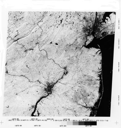
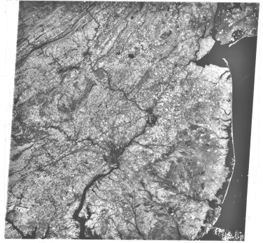
As a preview of change detection, compare the October 1972, Band 7 image above with the one below, which was taken on April 18, 1978. Because it's a time in the Spring in which trees and other vegetation have not yet leafed out there especially dark ridges whose tones result from rock and soil reflectances that contribute because of the absence of leaves). This results in a reduction in brightness over much of the areas in the lowlands where the fields remain fallow prior to emergence of growing vegetation. Many of the bright areas in this April image do correlate with some field crops that were planted earlier; small bright patches in the Pine Barrens are sand pits - highly reflective in all bands.
MSS Band 7
MSS April 18, 1978

Collaborators: Code 935 NASA GSFC, GST, USAF Academy Webmaster: Bill Dickinson Jr.
Primary Author: Nicholas M. Short, Sr. email: nmshort@epix.net
Contributor Information
Last Updated: September '99
Site Curator: Nannette Fekete
Please direct any comments to rstweb@gst.com.