
Now, at last we approach the finale of this Tutorial section during which we show three of the common methods for identifying and classifying features in images. We explain unsupervised and supervised methods.
In an unsupervised classification, the objective is to group multiband spectral response patterns into clusters that are statistically separable. Thus, a small range of digital numbers (DNs) for, say 3 bands, can establish one cluster that is set apart from a specified range combination for another cluster (and so forth). Separation will depend on the parameters we choose to differentiate. We can visualize this process with the aid of this diagram, taken from Sabins, "Remote Sensing: Principles and Interpretation." 2nd Edition, for four classes: A = Agriculture; D= Desert; M = Mountains; W = Water.
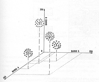
From F.F. Sabins, Jr., "Remote Sensing: Principles and Interpretation." 2nd Ed., © 1987. Reproduced by permission of W.H. Freeman & Co., New York City.
We can modify these clusters, so that their total number can vary arbitrarily. When we do the separations on a computer, each pixel in an image is assigned to one of the clusters as being most similar to it in DN combination value. Generally, in an area within an image, multiple pixels in the same cluster correspond to some (initially unknown) ground feature or class so that patterns of gray levels result in a new image depicting the spatial distribution of the clusters. These levels can then be assigned colors to produce a cluster map. The trick then becomes one of trying to relate the different clusters to meaningful ground categories. We do this by either being adequately familiar with the major classes expected in the scene, or, where feasible, by visiting the scene (ground truthing) and visually correlating map patterns to their ground counterparts. Since the classes are not selected beforehand, this latter method is called unsupervised.
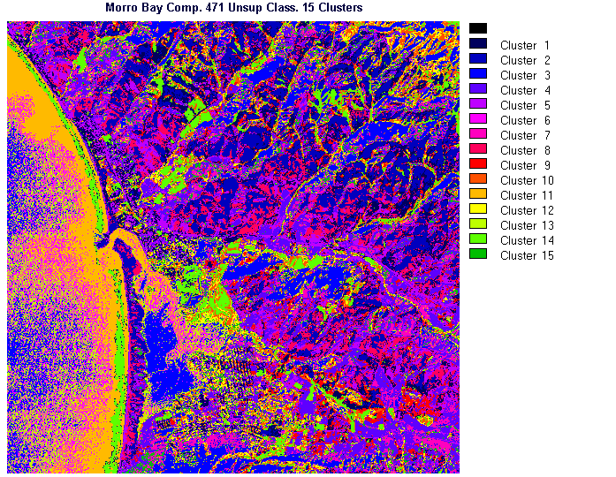
The IDRISI image processing program employs a simplified approach to unsupervised classification. Input data consist of the DN values of the registered pixels for the 3 bands used to make any of the color composites. Algorithms calculate the cluster values from these bands. It automatically determines the maximum number of clusters by the parameters selected in the processing. This process typically has the effect of producing so many clusters that the resulting classified image becomes too cluttered and, thus, more difficult to interpret in terms of assigned classes. To improve the interpretability, we limited the number of classes to 15 (reduced from 28).
1-20: What's to be done if one uses more than three bands to make an unsupervised classification? ANSWER
The first unsupervised classification operates on the color composite made from bands 2, 3, and 4. Examine the resulting image.
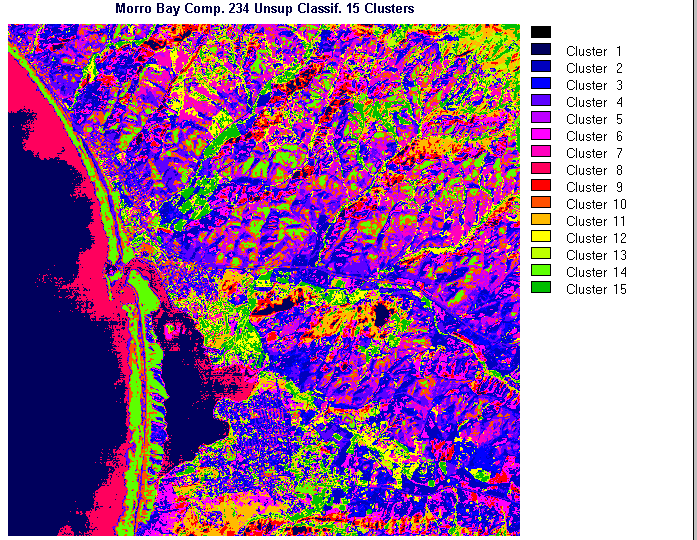
Try to make some sense of the color patterns as indicators of the ground classes you know from previous paragraphs. A conclusion that you may reach is that some of the patterns do well in singling out some of the features in parts of the Morro Bay subscene. But, many individual areas represented by clusters do not appear to correlate well with what you thought was there. Unfortunately, what is happening is a rather artificial subdivision of spectral responses from small segments of the surface. In some instances, we see simply the effect of slight variations in surface orientation that changes the reflectance's or perhaps the influence of what we said in the Overview was "mixed pixels". When we try another composite,bands 4, 7, and 1, the new resulting classification has most of the same problems as the first. We conclude that unsupervised classification is too much of a generalization and that the clusters only roughly match some of the actual classes. Its value is mainly as a guide to the spectral content of a scene to aid in making a preliminary interpretation prior to conducting the much more powerful supervised classification procedures.
1-21: Critique these two unsupervised classifications. What is shown well; poorly? Do you find it very helpful in pinpointing potential classes to be identified and then used in carrying out a supervised classification? ANSWER

Primary Author: Nicholas M. Short, Sr. email: nmshort@epix.net
Collaborators: Code 935 NASA GSFC, GST, USAF Academy
Contributor Information
Last Updated: September '99
Webmaster: Bill Dickinson Jr.
Site Curator: Nannette Fekete
Please direct any comments to rstweb@gst.com.