
Returning for a moment to the two other visible bands, Landsat TM 2 and 3, which monitor reflected light broadly distributed in the green and red bands, respectively. First look at band 2 (left) and then band 3 (right)
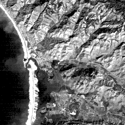
and, if you wish, compare each of them to bands 1 and 4. On first glance, there seems to be little difference in tonal variations for features imaged in bands 1 through 3. The most perceptible change is the extent of the ocean sediment patterns diminishing from 1 through 3. The sun-facing slopes in the hill country seem a bit brighter in 3 than in the other two bands, perhaps influenced by the red component in light reflected from a surface underlain by brown soils and also by the brown color of the grass.
Because of the apparent similarities in tone for major features seen in the first 3 bands, we might wonder how they combine so well a color composite, which we will inspect shortly. The answer to this question is subtle and rather complex but here is the essential reason: when images for the individual bands are generated, they have appropriate contrasts. The images have similar tonal variations for the ground classes, because most of the features have approximately the same relative differences in reflectance in each band. But, their actual reflectance values (partially embodied in their DN's or digital numbers [see introductory section for more details] ) vary more from one band to the next. Thus, a green reflector may have a higher average DN value in band 2 than in 1 or 3 and that will contribute more effective brightness to the green component of a color composite.
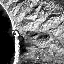
Now, we will finish our look at the black and white renditions of the individual bands by displaying TM band 5. This band, centered around 1.65 µm, most closely resembles band 7 but by flipping back and forth into 7 and 5 you should be able to pinpoint several moderate differences. In the beachbar (c), band 5 shows a moderately darker tonal variation, with some structure in the patterns within the sand other than that caused by vegetation. As with 7, the breakers have lost most of their reflectance output and appear therefore as mottled medium-dark grays. The mysterious feature (s) has good internal contrast highlighting the distinctive patterns that give away its identity (to the imaginative). The urban areas' structure, defined by the crisscrossing street patterns, (within towns labeled in yellow on the overlay map), is rather washed out in the band 5 version. The two rows of bright dots representing storage tanks near the power plant (t) almost disappear in 5 (and 7).
1-9: There is something in Bands 5 and 7 that is almost absent from view by its lack of contrast; but, this feature stands out in Bands 2 and 3. What is it? (Hint: it's in the lower half of the image.) Which band seems lighter overall, 5 or 7? ANSWER

Primary Author: Nicholas M. Short, Sr. email: nmshort@epix.net
Collaborators: Code 935 NASA GSFC, GST, USAF Academy
Contributor Information
Last Updated: September '99
Webmaster: Bill Dickinson Jr.
Site Curator: Nannette Fekete
Please direct any comments to rstweb@gst.com.