
THE HUMAN REMOTE SENSER IN SPACE:
ASTRONAUT PHOTOGRAPHY
Guest Writer: Dr. Paul D. Lowman, Jr.
Code 921, Goddard Space Flight Center
Greenbelt, Maryland 20771
Every U.S. manned mission since 1962 has included a look back at Earth by film photography, generally with hand-held cameras. This photography has been one of the most productive but least-known products of the U.S. civilian space program. This Section briefly summarizes the history and current status of such photography, focusing especially on geologically useful targets, i.e., land areas. We present the photography according to each program, although photography is rarely more than an incidental activity on most manned missions. (Women routinely fly on NASA missions, so, euphemisms for "manned" are not necessary). We add one example from the Soviet/Russian missions.
12-1: To get you into the mood to think "astronautical", who was the first man in space, the first American in space, the first American to orbit Earth, and the first "dynamic duo" of Americans to orbit the planet? ANSWER
For the missions in general, the most readable and authoritative account is a book entitled, "Liftoff" (1988) by one of the astronauts, Michael Collins of Apollo 11 fame *. A general reference covering all of American space photography through 1989 appears in the journal Geocarto International, vol. 4, no. 1, 1989. Collections of astronaut photographs prior to those shot from the Space Shuttle are the mainstays of two books, "Space Panorama" and "The Third Planet" by the author (PDL, Jr.) *.
For readability, we cite references by placing a blue asterisk near or next to individuals involved, such that the reader can access the full reference optionally. We list only the most important references this way. The literature on the subject is now quite extensive. We follow the same approach, cited by a double asterisk (**), for several tables that list photo equipment used in various missions.
Internet access to information about most of the U.S. astronaut missions, along with selected photos taken during these flights, is available at http://images.jsc.nasa.gov (select the Press Release option button).
We can trace the beginnings of space photography to automated cameras onboard V-2 rockets fired in the mid 1940s from the White Sands Proving Grounds in New Mexico. From then, through the early days of NASA, cameras documented various sounding-rocket and missile launches. An example is this photo taken by an automatic K-12 camera, using black and white infrared film, from a Viking sounding rocket that reached a height of 227 km (141 miles). This film was recovered from the crashed vehicle after it fell back to Earth. The scene viewed here extends southwestward across parts of New Mexico, Arizona, Nevada, California, and northwest Mexico (upper Gulf of California on the left).
Mercury and Gemimi Photography
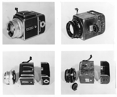
Astronaut photography started with the Mercury program. The unmanned MA-4 mission carried an automatic 70mm camera that returned systematic coverage of North Africa. NASA sent the photos to Morrison and Chown of Canada's McGill University for detailed analysis. All four Mercury orbital missions included hand-held cameras, primarily the precision German-made Hasselblad cameras, available commercially:
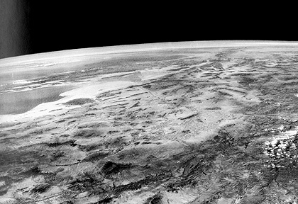
It was only in the last two missions, MA-8 and MA-9, that systematic terrain photography was a formal experiment. The astronauts for these missions, W.M. Schirra (8) and L.G. Cooper (9) had one 3 hour briefing by the writer, covering principles of geology, geology of the flight path, areas to be photographed, and a rock collection for study. Schirra's pictures, though taken precisely as scheduled, were largely spoiled by cloud cover over the Brazilian Shield, the only area we expected to be accessible within the short flight time (six revolutions). However, with more than 34 hours flight time, Cooper had far more opportunities to photograph pre-selected sites and targets of opportunity. The 24 excellent Hasselblad color photos he took, including these of the west coast of Burma (top), with its Arakan Yoma Mountains, and the Irawaddy River to the east, and the high mountains of the Himalayas (bottom), received wide publicity, and led to subsequent terrain photography experiments on the Gemini missions.
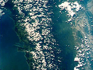
The Gemini Program (two astronauts to a spacecraft) was a major step forward in U.S. space capability. Intended solely to prepare for Apollo, ten manned missions flew in 1965-66, accomplishing orbital rendezvous, extravehicular activities, tethered flight, and many scientific experiments including 70 mm terrain and weather photography. The Synoptic Terrain Photography Experiment (S005) produced some 1,300 usable 70 mm color pictures of the Earth's surface. These were an enormous stimulus to space-borne remote sensing, partly because they were released to the public without restriction. Among spectacular photos returned from the Gemini 4 mission is this oblique panorama showing Egypt's Nile Delta in the foreground, with the Gulf of Aqaba-Dead Sea in the background:
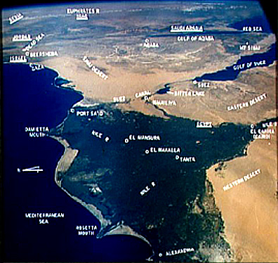
12-3: Does this picture give you a clue as to the origin of the term "delta"? ANSWER
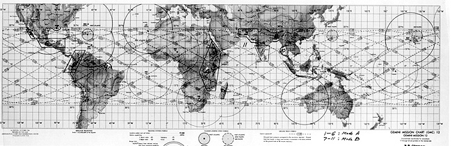
The flight plan (plots of orbits) for Gemini 12 is shown in this map:
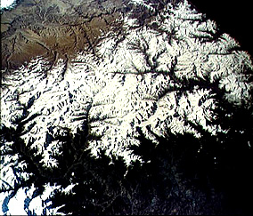
One of the key photos obtained during this mission shows Oman, the Straits of Hormuz, the Persian Gulf, and part of the Zagros Mountains of Iran.
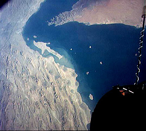
12-4: Which way is South in this picture? ANSWER

Primary Author: Nicholas M. Short, Sr. email: nmshort@epix.net
Collaborators: Code 935 NASA GSFC, GST, USAF Academy
Contributor Information
Last Updated: September '99
Webmaster: Bill Dickinson Jr.
Site Curator: Nannette Fekete
Please direct any comments to rstweb@gst.com.