Atmospheric Sounders
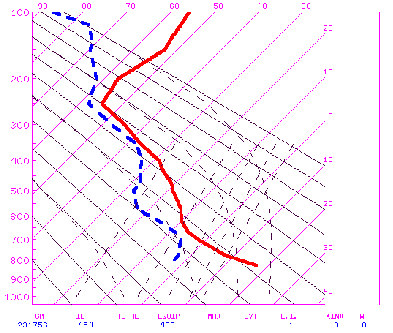
Another class of sensors gathers valuable data about the atmosphere in a three-dimensional mode, to various depths. These sensors are the sounders, which can look vertically through atmospheric levels or look off-nadir through longer paths, particularly through the atmospheric limbs, nearly tangent to the Earth's surface. Among many such instruments, we can mention as typical: the High Resolution Infrared Sounder (HRIS - 20 channels that cover from the visible to 15 µm, and its resolution is coarse at 42 km); the Stratospheric Sounder Unit (SSU); the Microwave Sounder Unit (MSU); the Visible Infrared Spin-Scan Radiometer (VISSR), a two-channel sounder on GOES, which also may have the GOES 1-M sounder; the Solar Backscatter UltraViolet (SBUV-2) radiometer; the Limb Infrared Monitor of the Stratosphere (LIMS); and the Stratospheric Aerosol and Gas Experiment (SAGE). Sounders are especially suited to obtaining temperature, water vapor, ozone, and other trace-gas data that we can plot in profiles. Here is an example (somewhat degraded) of temperature (red) and water vapor (blue) profiles over Denver, Colorado, on January 13, 1997, as calculated from the GOES-8 Sounder.
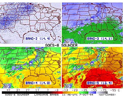
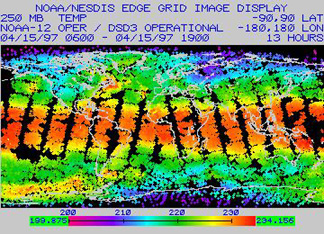
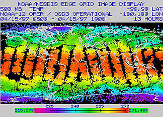
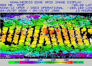
One way in which a sounder can sense levels in the atmosphere is illustrated in the diagram below. Each temperature map was made at a specific wavelength that is capable of measuring the radiant temperature in the atmosphere at some particular altitude (or depth within the air column, which can also be expressed in terms of atmospheric pressures in millibars). The map progression from upper left to lower right follows a trend of decreasing height above the surface. Note especially in the lower pair that the lateral temperature variation is from cooler in the northwest to warmest in the southeast.
Soundings can also be made in the microwave region. At different frequencies (or wavelengths, especially in the millimeter range), the return signals give blackbody-equivalent temperatures at different depths.
Sounders are especially suited to obtaining temperature, water vapor, ozone, and other trace-gas data that can be plotted in profiles. Here is a (somewhat degraded) example of temperature (red) and water vapor (blue) profiles over Denver, Colorado on January 13, 1997 as calculated from the GOES-8 Sounder (see page 14-7 for details).
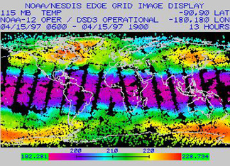
However, because satellites sweep over much of the Earth, particularly those in near-polar orbits (see below), and thus, take data readings continuously as they orbit, we can present the sounding data as global maps. As an example, consider these maps of global temperatures at four different altitudes (specified as pressures in millibars), as obtained by the TIROS Operational Vertical Sounder (TOVS) on Nimbus 12 on April 15, 1997 (115 mbars is approximately at 15 km and 950 mbars is near the surface):
We display a number of similar maps made from atmospheric sounder instruments on metsats elsewhere in this section.
14-6: For a location on the equator, from the above 4 image panels, estimate the temperature profile on this infamous date (April 15, 1997, when much additional heat was probably added to the atmosphere from irate taxpayers). ANSWER
We can only scratch the surface (really, the atmosphere) on this subject of metsat instrumentation. For example, the Nimbus series actually supported 24 different experimental systems, involving a variety of sensors. The interested user should consult Kidder and Vonder Haar.
Classes of Metsats
Meteorological satellites fall into two general classes in terms of their orbital characteristics. We can group most into the Polar Orbiting Environmental Satellite (POES) category. These launch into orbits at high inclinations to the Earth's rotation (at low angles with longitude lines), such that they pass across high latitudes near the poles. Depending on orbital altitudes, angular velocities, and inclinations, these satellites are sun-synchronous, that is, they cross the equator southbound about 11° westward (as Earth rotates underneath) with each trip around the world (about 105 minutes long), so that they cross some reference position (e.g., the equator) at the same local time. This time is usually between mid-morning and mid-afternoon on the sunlight side of the orbit. Thus they image their swaths at about the same sun time during each pass, so that lighting remains roughly uniform. Of course the clouds change with each orbit, but their broad patterns and positions remain mostly unchanged in the short orbital periods involved. From this method, we can make a daily mosaic from the swaths, which is a good general summary of global weather patterns for that period. This same orbital configuration applies to Landsat, SPOT, and some of the other land observers. Other POES members have inclinations or other orbital constraints, such that they cross equivalent latitudes at different times of day, allowing observations over various times in the diurnal cycle. Most POES orbits are circular to slightly elliptical at distances ranging from 700 to 1700 km (435 - 1056 mi) from the geoid. At different altitudes they travel at different speeds.
The second type of metsat is in the Geostationary Operational Environmental Satellite (GOES) class. These satellites are geosynchronous, meaning their orbits keep them synchronized with Earth’s rotation, i.e., they take 24 hours to complete one orbit. To have a 24 hour orbital period, they must keep an orbital altitude of 35,780 km (22,234 mi, or about 5.61 Earth radii), which sets their speed at 3.07 km/s (6,868 mph).An equatorial point travels underneath at a speed of about 0.465 km/s (1,040 mph).
When these satellites orbit above the equator, with zero inclination, they are also geostationary (fixed) relative to a point on the equator, so that they observe the Earth without any significant relative motion. At this distance, and with a wide FOV, they see the Earth as a full disk, but the area covered is less than a hemisphere, being about 1/4th of the planetary surface.
The Earth and satellite, synchronized, rotate relative to the Sun, so that part of each day, the satellite's sensors face the night side. But, because of this night effect, to view the Earth in daylight continuously requires at least three (preferably four) geostationary satellites located equidistantly around the globe. Under these orbital conditions, the sensors can look at the disk at any moment, gaining a synoptic image, in which it views all meteorological elements in real time. We acquire visible images typically 30 minutes apart and infrared images less often. GOES platforms usually operate in pairs, spacing about 75° apart. We refer to current GOES units above the western hemisphere as GOES-East and GOES-West.
14-7: Which type of satellite most likely gives you the cloud movement panorama you see n the nightly TV news? ANSWER
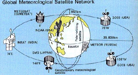
We expand upon some of the above information later in this section. We build its content around four objectives: 1) the historical development of metsat programs; 2) examples of the kinds of data/information, as rendered in images and maps, supplied by these systems; 3) emphasis on the global nature of many of the observations; and 4) consideration of oceanographic and land hydrologic investigations. This next figure offers a quick look at most of the major metsat systems now operating to provide worldwide or hemispherical coverage.

Primary Author: Nicholas M. Short, Sr. email: nmshort@epix.net
Collaborators: Code 935 NASA GSFC, GST, USAF Academy
Contributor Information
Last Updated: September '99
Webmaster: Bill Dickinson Jr.
Site Curator: Nannette Fekete
Please direct any comments to rstweb@gst.com.