
The NOAA Series
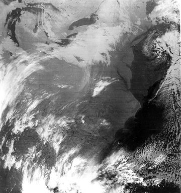
The present-day series of operational metsats can trace its inception to the launch of TIROS-M on January 23, 1970. Also called ITOS (for Improved TIROS Operational System), it included several vidicon cameras and an IR radiometer sensing between 3.4-4.2 µm. The first of the NOAA series (TIROS 2 to 5) followed this initial satellite. Here is a typical image, showing the eastern U.S., made by the NOAA-4 Very High Resolution Radiometer (VHRR), operating in the near-IR region.
A new series in this generation began with the launch of TIROS-N on October 13, 1978. This satellite was the first to carry the AVHRR (described on page14-2), along with the first sounder, TIROS Operational Vertical Sounder (TOVS), designed to profile temperature and water vapor. The TOVS is actually a three instrument complex: the High Resolution IR Sounder (HIRS-2), with 20 channels; the Stratospheric Sounding Unit (SSU), with three channels near 15 µm, and the Microwave Sounding Unit (MSU), a passive scanning microwave spectrometer with four channels in the 5.5 µm interval. These instruments are the mainstays of the subsequent NOAA-6 (launched on June 27, 1979) through NOAA-14 (December 30, 1994) metsats. The SBUV is also part of NOAA-9 and NOAA-11. Even-numbered NOAA metsats have North to South equatorial crossing times near 7:30 A.M. and have orbital repeat periods (re-occupy approximately the same paths) of four to five days. The odd-numbered ones cross the equator from North to South at night (2:30 A.M.) and have eight-nine day repeat periods.
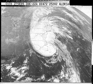
Here is a NOAA-9 AVHRR image in the visible region of Hurricane Gloria, as it neared the East Coast on September 27, 1997:
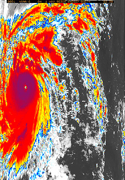
Next, a NOAA-6 IR image, in which lighter tones are color-enhanced to bring out details, of Super Typhoon Angela in the western Pacific, shows its status on November 11, 1995:
Like most multi-channel systems, we can combine different AVHRR-band images into color composites, as demonstrated by this rendition of Hurricane Fran on September 4, 1996:
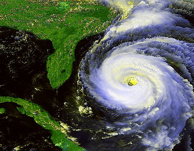
14-15: This is a classic portrayal of a hurricane's appearance. Deduce from the directions of motion implied by the swirls in the hurricane's spiral pattern which way the circulation (clockwise or counterclockwise) of the winds is taking place. ANSWER
The former Soviet Union/CIS has launched more than 25 polar-orbiting metsats in its three Meteor Series, starting in March of 1969, and continuing through 1994. Other metsats were part of their Kosmos series

Primary Author: Nicholas M. Short, Sr. email: nmshort@epix.net
Collaborators: Code 935 NASA GSFC, GST, USAF Academy
Contributor Information
Last Updated: September '99
Webmaster: Bill Dickinson Jr.
Site Curator: Nannette Fekete
Please direct any comments to rstweb@gst.com.