
EOS Platforms/Sensors and Mission Profiles
Addressing the scientific questions often requires that we design several instruments–each addressing a different but related issue–to work together. We mount this suite of instruments on a spacecraft that launches into a carefully-designed, Earth orbit. The instruments dictate the spacecraft’s size and its design, as well as the size of available launch vehicles, etc. The Earth Observing Satellite (EOS) series meet these specifications (get more details on this and the rest of the EOS-AM program at http://eos-am.gsfc.nasa.gov/).
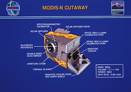
An example of a state-of-the-art instrument built for the first EOS flight (EOS-AM), is the Moderate Resolution Imaging Spectroradiometer, or MODIS. MODIS measures biological and physical processes on a global basis, every one to two days. The instrument provides long-term observations, from which we enhance our understanding of global dynamics and processes occurring on the Earth’s surface and in the lower atmosphere. The MODIS instrument employs a conventional imaging radiometer, consisting of a cross-track scan mirror and collecting optics, and a set of linear detector arrays with spectral interference filters located in four focal planes. The optical arrangement provides imagery in 36 discrete bands (hyperspectral mode), selected for diagnostic significance in Earth science. The spectral bands have spatial resolutions of 250 m, 500 m, or 1 km at nadir (the point directly below the instrument). The instrument's data rates range from 6.2 Mbps (average) to 10.6 Mbps (day) to 3.2 Mbps (night). It is temperature-controlled by radiative cooling. The instrument’s mass is 225 kg, it has a 100% duty cycle, and requires 175 W (average) and 225 W (peak) power. In its stowed (launch) configuration, its dimensions are about 95 x 158 x 134 cm.
Because MODIS is the pivotal instrument on EOS, it is appropriate to list in detail its specifications.
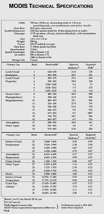
16-17: In the right column are two abbreviations: SNR and NE deltaT. What do these stand for and what do they measure? ANSWER
The instrument will provide long-term observations from which to derive an enhanced understanding of global dynamics and processes occurring on the surface of the Earth and in the lower atmosphere. The MODIS instrument employs a conventional imaging radiometer concept, consisting of a cross-track scan mirror and collecting optics, and a set of linear detector arrays with spectral interference filters located in four focal planes. The optical arrangement will provide imagery in 36 discrete bands (quasi-hyperspectral mode) selected for diagnostic significance in Earth science. The instrument's data rates range from 6.2 Mbps (average) to 10.6 Mbps (day) to 3.2 Mbps (night). It is temperature-controlled by radiative cooling. In its stowed (launch) configuration, its dimensions are about 95 x 158 x 134 cm.
16-18: Looking over the channels listed in the "specs", and their intended uses, how would you categorize MODIS as a satellite class? ANSWER
To ensure that measurements provided by the instrument are accurate, it uses a complex series of on-board calibrators. As the instrument’s scan mirror makes a revolution, these calibrators provide information on a per-scan basis that places the measurements in a trustworthy framework.
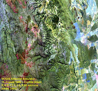
Here is an example of a characteristic 3-band color composite made with the MODIS Airborne Simulator (MAS) sensor using selected MODIS bands, showing a scene in Central Brazil taken in August of 1995.
MODIS has its own Home Page that gives updated information about that sensor.
In the case of the first EOS flight, known as AM-1 because of its designated morning equator-crossing time, four other instruments join MODIS, two of them coming from some of the program's International Partners:
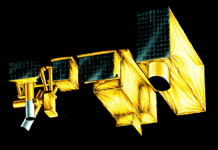
These instruments are on the EOS AM-1 spacecraft, as shown here (the order in the list conforms to the instruments in the diagram from left to right, plus MODIS on the far right):
Of special interest in this battery of instruments is ASTER , shown here.
A combination of wide-bandwidth coverage, high-resolution mapping, and stereo DEM is unique to ASTER. It operates in tandem with MODIS. ASTER contains a radiometer in the VNIR, which images in three bands (between 0.52 and 0.86 µm (15-m spatial resolution). A second radiometer uses six bands in the SWIR region between 1.6 and 2.43 µm (30-m resolution). The TIR (thermal emission) radiometer has five bands between 8.3 and 11.3 µm (90-m resolution). There is also a separate single band at 0.76-0.86 µm, inclined backward at 27.6Á from nadir that provide along-track imagery, capable of stereoscopic viewing with one of the VNIR bands to permit images in the DEM (Digital Elevation Model) mode. The VNIR bands measure snow, water, vegetation, and degree of oxidation of the land surface. The SWIR bands are optimized for mineral identification, especially hydrated minerals in clay-rich soils. The TIR bands identify major rock types and also take land-surface temperatures.
16-19: What groups of scientists and technologists are most likely to use ASTER? ANSWER
Each instrument on EOS has a mathematical (computer-based) model that allows scientists and engineers to determine its response to operating conditions. In addition, because each data-collecting measurement goes through an algorithm (a set of mathematical and operational instructions), a detailed analysis of all algorithms is available in an Algorithm Theoretical Basis Document (ATBD). The ATBD presents the scientific and physical basis for the measurement, and documents how to translate that basis into computer code that converts the physical measurement into data products. The data products give the geophysical parameters required to answer the questions that scientists and government planners ask.
Designed to have an orbital lifetime of at least six years, EOS AM-1 provides data on clouds, aerosols, and radiative balance. It allows us to characterize the terrestrial surface and provide data on the global carbon cycle.
Because EOS AM-1 is complex, it has neither the proper instrument complement nor the longevity to handle many of the other issues addressed by MTPE and related programs. How, then, do we acquire all the needed data?
EOS is a multi-year mission, with eighteen different orbit-based components, similar in concept (if not in detail) to AM-1. By designing many such spacecraft, based on the guidelines outlined above, we formulate a mission profile. The mission profile, over time, provides the necessary data. We present the EOS Mission Profile here:

To allow for flexibility in the mission, we haven’t assigned every instrument to specific flights. In several places we may fly an instrument as a "flight of opportunity," or "FOO." While this profile extends only to 2006, the full suite of instruments and flights continue beyond 2006 to provide a full 15-year-long data set, as required by scientific drivers to the program, as described above.
Landsat-7 launched in ??? of 1998. It operates independently and in synergistic support of EOS. We now consider it an integral part of the MPTE program. It mounts only one sensor, the Enhanced Thematic Mapper (ETM+) that has identical spectral wavelength coverage as earlier TMs (with the same 30-m resolution, except that the thermal band improved to 60 m). It also has (the +) a panchromatic (0.5-0.9µm) band with 15-m resolution. The special feature of Landsat-7 is its launch and orbital parameters, which allow the space vehicle to trail (follow) the EOS-AM platform (within its swath) by 15-30 minutes each day. Thus, we can integrate observations from both systems, and we can use atmospheric data from EOS sensors to correct for the effects of water vapor and temperature on Landsat images.

Primary Author: Nicholas M. Short, Sr. email: nmshort@epix.net
Collaborators: Code 935 NASA GSFC, GST, USAF Academy
Contributor Information
Last Updated: September '99
Webmaster: Bill Dickinson Jr.
Site Curator: Nannette Fekete
Please direct any comments to rstweb@gst.com.