
Fluvial/ Deltaic/ Coastal Landforms
Switching to fluvial landforms, of which there are many varieties, we show first an archetype of dendritic drainage and then below, a part of a Landsat mosaic, in which the dendritic drainage has highly dissected the topography in flat-lying rocks.
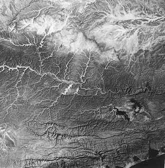
The South Yemen Landsat scene above extends over part of the Hadhramut Plateau, an uplifted section of Tertiary limestones and shales, which experienced folding into a broad syncline (center) and two anticlines (top and bottom of the image, but not visibly evident). Typical dendritic drainage develops as the Wadi al Masilah, which, along with its tributaries, is a sometimes ephemeral stream (its valley is sand-filled) that obtains flow mostly after large storms but maintains enough water to support local farming. Much of this drainage likely developed during a wet period before the regional climate shifted to its present arid state. Note the typical headwaters pattern for dendritic drainage in the system in the upper right. The drainage pattern near the coast has become trellis-like.
17-7: The term "dendritic" was introduced above, but not defined. Using the image as a clue, what do you think this word means, in a geomorphic sense? ANSWER
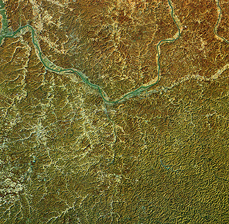
The above subscene (about 100 km [62 mi] wide) is in West Virginia, next to the Kentucky border. The Ohio River flows just to the north of the image top. The area is part of the Appalachian Plateau, an uplifted sector of the crust involved in the Appalachian orogeny that did not experience folding, so that the rocks remain horizontal. The drainage has reached a level referred to as mature, in which a distinctive high-density dissection has reduced divides to sharp ridges, with little of the earlier uplands remaining, and narrow valleys. Although this pattern leads to maximum relief, the differences in elevation are seldom more than about 200 meters (656 ft).
In Section 4, we showed one example of a river delta: the bird's foot delta of the Mississippi River as it builds into the Gulf of Mexico in Louisiana, south of New Orleans. Here are two more classic examples:
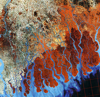
This Landsat image shows about half (the western part) of the Ganges Delta in Bangladesh (the India border is near the left edge, and Calcutta is at the center of the left edge). This is the world's largest delta, being more than 200 km (124 mi) in straight distance along the Bay of Bengal. The delta results from deposition of heavily silt-laden waters of the Ganges and the Brahmaputra Rivers, transporting sediment from the Himalayas far to the north.
The present-day Ganges drains southward just off the image to the right. That segment is now the active delta region. In the scene above, we see the so-called abandoned delta which formed in the past when the Ganges flowed in various positions and shifted gradually eastward. Other rivers still flow into the Bay adding somewhat to the delta, as seen in the light blue sediment flowing into marine waters. These quasi-distributaries become tidal channels that tidal currents highly influence. The dark red tones along the coast are mangrove forests and swamps. In the upper left quadrant, the area is part of the depauperate delta, where the clay soils now support sporadic agriculture. People seeking farmland removed much of the forest that was once there. The entire region, especially the low flat areas near the coast, is vulnerable to frequent cyclones (hurricanes) that cause widespread damage and loss of life, because of high winds and tidal surges.
This next Landsat Band 7 (IR) image covers the central west coast of Alaska. Here the Yukon River flows into Norton Sound on the northeastern Bering Sea.
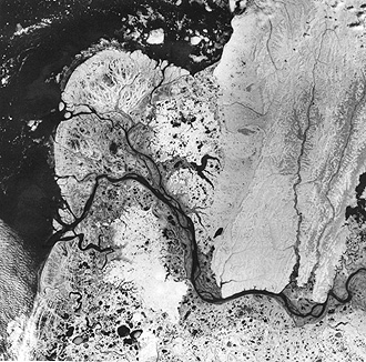
The main branch now carries sediment to the south end of a large semi-circular delta. It is actively extending the delta but an offshoot tributary is doing much of the deposition in the central part. This present delta is young (perhaps only a few thousand years since its start) that began with a major shift of the Yukon from a location not in this scene. Within and inland from the delta are numerous small lakes of ice origin. Along the coast at the bottom of the image are linear bands, which are beach ridges, developed when sea level was higher.
17-8: What is/are the main difference(s) between the Ganges and Yukon deltas? ANSWER
The two, coastal-landform examples display special types that also fall into two general categories: coastlines of submergence and emergence.

The above scene lies in the Coastal Ranges along the Pacific Ocean in the region where the Alaskan Panhandle extends along Canada (near the top of the image). Juneau, Alaska's capital, is near the center. The region is tectonically active, with major faults separating individual crustal units known as terranes (see below). These faults and other structural features served as lines of weakness for erosional attack by streams and glaciers, which together carved out deep valleys. Some present day glaciers are visible in the Glacier Bay National Park area northeast of Juneau and elsewhere. After the close of the last major glaciation, melting glaciers are now in retreat to the extent that the ocean flowed into some large valleys cut earlier to below sea level by the ice, effectively drowning them. The resulting landform is a fjord–a Norwegian name assigned to submerged coastal valleys once occupied by ice.
17-9: How do you think the scenery shown in the above image has strongly influenced the economy of the region? ANSWER
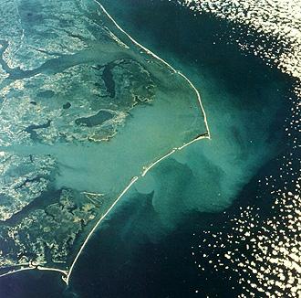
The Atlantic seaboard, seen above, is generally now a coast of emergence associated with regional uplift. Over the past 50 million years or so, seas have lapped well onto the eastern North American continent, laying down thick, subhorizontal sedimentary layers, but the ocean has been gradually retreating eastward. In the last few thousand years, a rise in sea level, resulting from glacial ice melt, has reversed this trend as marine waters drown coastal valleys (e.g., Chesapeake Bay) and push shorelines inland. Along much of the Atlantic coast from New Jersey to Florida, thin narrow lines of sand deposits, built up above sea level by deposits from ocean waters encroaching on shallow bottom slopes, form barrier islands. The image is a photo taken by an Apollo 9 astronaut of the famed Outer Banks of North Carolina. The point farthest east is Cape Hatteras, and the southern point is Cape Lookout. The wide stretch of water towards the mainland is Pamlico Sound, which, with Albemarle Sound inland to the north, we term a lagoon. Offshore, submerged sandbars–incipient islands–form hazards to shipping. Because of the irregular, cuspate coastline west of the barrier, geomorphologists argue that the island had already formed prior to current onlap by ocean waters, thus protecting the inner shores from wave erosion.
17-10: Why is it risky to live on the Outer Banks? ANSWER

Primary Author: Nicholas M. Short, Sr. email: nmshort@epix.net
Collaborators: Code 935 NASA GSFC, GST, USAF Academy
Contributor Information
Last Updated: September '99
Webmaster: Bill Dickinson Jr.
Site Curator: Nannette Fekete
Please direct any comments to rstweb@gst.com.