
How has remote sensing played a role in the search for or verification of a supposed impact crater? In two ways: 1) recognizing morphological features that are compatible with an impact origin (but this does not rule out certain volcanic craters) and 2) detecting shock-induced changes as spectral changes. The strategy is one of simply using remote sensing to identify landform anomalies consistent with an impact origin and then confirming them by on-site inspection and examination of rocks for shock metamorphic effects. The absence of shock effects leads to ambiguities, making volcanic craters an alternative hypothesis. We have discovered at least four new impact structures through remote sensing.
We can gain a feel for what to look for, and the variations in morphologic expression due to differences in erosional state, at a crater site, by switching again to the Geological Survey of Canada's Web Page on Impact Cratering (http://gdcinfo.agg.emr.ca/crater/world_craters.html). Go to the list of individual craters and check these especially interesting sites: North America: Brent/Clearwater East and West/ Deep Bay/ New Quebec; South America: Araguainha; Africa: Aorounga/ Bosumtwi/Rotor Kamm/Vredefort; Europe: Ries; Asia: Bigach/Popigai; and Australia: Henbury/Wolfe Creek.
18-12: With this practice behind you, we challenge you to find the crater in this Landsat scene. ANSWER
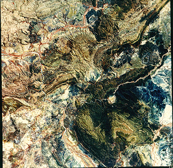
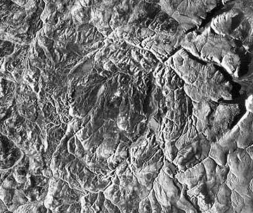
If you succeed in the hunt, you will have pinpointed the 6 km (4 mile) wide Goat Paddock crater in Western Australia. Interior Australia is the home of perhaps the most dramatic exposure of the central peak of a complex crater anywhere in the world, seen below in this aerial oblique view of a ringed mountain at the Gosses Bluff Crater.
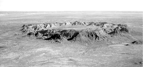
The 6 km (4 mi) wide ring consists of layers of resistant sandstone, tilted at steep angles as the strata were driven upwards on end, during the rebound of the crater floor into the peak. They have since been breached so that the lower interior now exposes softer rocks being eroded. In the Large Format Camera photo below, taken from the Shuttle, this central peak stands out in sharp contrast to the folded rocks of the McDonnel Range to its north.
Erosion nearly obliterated the outer sections of the crater, but they are faintly expressed as a dark band in the photo. Field studies show the approximate diameter of the full crater is 22 km (14 mi).
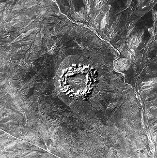
Water often fills complex craters sufficiently intact to retain a central depression. A Seasat radar image of the Elgygytgyn Crater in Siberia (its diameter is 18 km [11 mi]) is a good example. The aerial oblique view offers a different perspective.
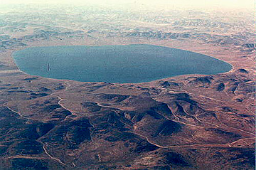
18-13: The Elgygytgyn Crater interior, defined by the lake, seems almost squarish rather than round. Speculate on the cause of this departure from the normal inner shape of impact craters. ANSWER
A different kind is Manicouagan, a 100 km (62 mi) structure in southern Quebec, Canada, which has a great central peak area of igneous and metamorphic rocks, among which are feldspar-rich rocks. In these rocks, much of the feldspar has transformed by shock into glass, known as maskelynite. Similar to Manson, there is a depression or moat between the peak and rim (now eroded) that formed annular valleys, which filled with water when a hydroelectric power dam blocked the draining rivers.
Because of this outline, astronauts journeying back from the Moon could see this crater from well out in space.
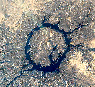
A SIR-B radar image of southern Ontario highlights two juxtaposed but unrelated craters that are very different in age, in size, and in structural state.
The partially circular lake-filled structure on the right (east) is the 8 km (5 mi) wide Wanapitei crater, estimated to have formed 34 million years (m.y.) ago. The far larger Sudbury structure appears as a pronounced elliptical pattern, more strongly expressed by the low hills to the north. This huge impact crater () was created about 1800 m. y. ago. Some scientists argue that it was at least 245 km (152 mi) across when it was circular. The strong northwestward thrusting of the Grenville Province terrane against the Superior Province (containing Sudbury) subsequently deformed it, more than 900 m. y. later. After Sudbury was initially excavated, magmas from deep in the crust invaded the breccia filling, to emplace against its walls. Some investigators think that the resulting norite rocks are actually melted target rocks. This igneous rock is host to vast deposits of nickel and copper, making this impact structure a multi-billion dollar source of ore minerals.
14: Which part of the elliptical rim of Sudbury seems to have better topographic expression? ANSWER
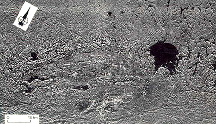
Radar can sharpen the appearance of an impact structure, as demonstrated with this aerial radar image of the Haughton crater (24 km, 15 mi wide) in Canada. Although about 23 m. y. old, much of the crater's morphology has survived erosion.
18-15: Where does the crater rim of Haughton appear to be? ANSWER

Primary Author: Nicholas M. Short, Sr. email: nmshort@epix.net
Collaborators: Code 935 NASA GSFC, GST, USAF Academy
Contributor Information
Last Updated: September '99
Webmaster: Bill Dickinson Jr.
Site Curator: Nannette Fekete
Please direct any comments to rstweb@gst.com.