
In the Plateau, there is one structural exception to this. In places, the rocks are gently folded in broad warps called anticlines and synclines, in which rock layers become inclined (we say they dip) in opposing directions. Even more common are a type of folds called monoclines.
The scene below is a beautiful Landsat MSS full scene taken on June 13, 1977. That shows the northwestern section of the Colorado Plateau, including parts of the so-called Canyonlands.
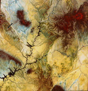
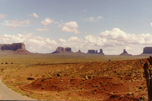
Most of the upper scene lies in Utah but the lowermost areas fall within northern Arizona. Passing through the scene is the Colorado River that, backed up from the Glen Canyon Dam (lower left) near Page, fills the steep-walled canyons to form Lake Powell. The San Juan River joins the Colorado from the east. The prevalent yellow color in this image (printed on Cibachrome, which improves both color quality and definition of features) corresponds mainly to sandstone's and some shales that are reds and oranges in nature. The brown tones associate with rocks that are dark reds and browns in the field. Some fields are tinged with reds in the image because vegetation in this IR version. Blues associate with shales that in the field are often grayish. Areas with strong red (IR) tones include the Abajo Peaks (upper right), the Henry Mountains (upper left), and the smaller, isolated Navajo Mountain east of Lake Powell. The northernmost end of the forested Black Mesa appears along bottom center. The cluster of brownish, isolated mountains to its north are the collection of mesas and buttes, which are erosional remnants of red and brown sandstone-capped hills that make up Monument Valley, a popular scenic backdrop in many classic western TV shows (a favorite haunt of the actor, John Wayne) and present day-TV ads. Compare the ground appearance of these striking prominences (look for them in the commercials, especially for autos) with their Landsat image.
Along the right side of the image is a long band of folded rocks that comprise Comb Ridge. In the upper left is the monoclinal fold known as the Waterpocket Fold, which is the topic of the next few pages of Section 2. The black line across it delineates the flight path of the aircraft mission flown by NASA for this writer, as discussed in the next several pages.
In a monocline, forces cause rocks to change their inclination in only one direction and then resume the initial direction, as depicted in this sketch
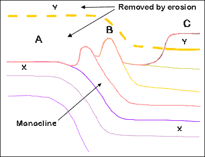
which presents a side view (as though it was along a vertical cut into Earth) of a monocline. At the top is a line which represents a profile of the ground surface. At B, above the inclined layers, rocks that are more resistant to erosion are shown as ridges (often called "hogbacks" or "flatirons"). At A, a rock unit labeled X lies just beneath the surface, but at B it has dipped downward such that it is now well below the ground. A unit labeled Y at C is well on top of X. These rock units and the rocks in between follow the stratigraphic Law of Superposition, which states the obvious: younger rocks are deposited on, and thus rest above, older rocks. If we follow Y to the left along a dashed line, it bends upward at B and also lies above the ground at A. In other words, it was once there but has been removed by erosion.
2-4: The two most common types of folds are called anticlines and synclines. Do you know what these structural terms mean? If not, check the answer. ANSWER
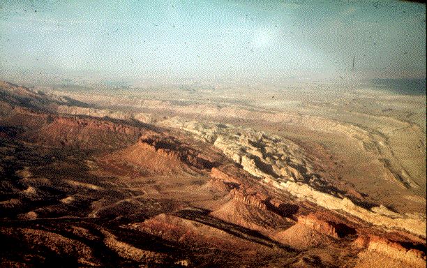
This is the situation at the Waterpocket Fold, a monocline which runs across this subscene. A black & white view
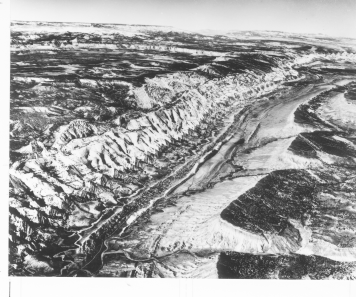
followed by a color view, both taken looking to the northwest from low-flying airplanes, show a hogback ridge
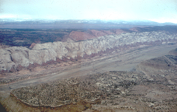
dominated by a whitish unit, the famed Navajo Sandstone (the principal rock formation at Zion National Park) and several other (reddish) units near its base. The thick red unit beyond (west) the Navajo Sandstone is the Wingate Formation. These several units dip at angles as steep as 45 degrees. Younger gently dipping rocks in the foreground (bottom of photo) are part of the lower bench of the Tarantula Mesa whose top (east of the photo; equivalent to C in the above diagram) is actually higher in elevation than the fold. We can barely see older rocks (equivalent to A) below the distant western horizon. These make up the Circle Cliffs. A third aerial view taken from the west side of the fold looking to the northeast, presents these older rocks to the left and younger rocks in the distance, with the Fold highlighted by the Navajo Sandstone and standing out as a narrow band of outcrops along the structurally-controlled topographic ridge.
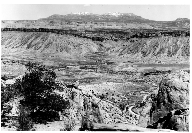
Now, we take two close-up looks from the ground, one looking up against the Fold
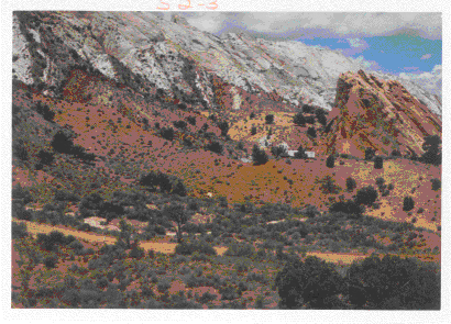
with the Navajo Sandstone near the top and the Entrada Sandstone (reddish) below it but stratigraphically young. The second photo looks eastward at Tarantula Mesa (a stepped, flat-topped, plateau) with the Mesaverde Sandstone capping it; the famous Henry Mountains (where Gilbert conceived the idea of a laccolithic intrusion) against the skyline; and the Dakota Sandstone as a blocky outcrop in the foreground.
2-5: In the first color photo (which the writer made literally hanging out the window of a light aircraft), how many rock units within the steeply inclined limb of the monocline can you separate visually. In the black and white aerial oblique photo, the slightly inclined rock units along the right side margin seem blackish; why? ANSWER

Collaborators: Code 935 NASA GSFC, GST, USAF Academy
Contributor Information
Last Updated: September '99
Webmaster: Bill Dickinson Jr.
Site Curator: Nannette Fekete
Please direct any comments to rstweb@gst.com.