
The U.S. Capital: Washington, D.C.
4-9: This general question, or activity, applies to this whole page. Each of the images represents a higher resolution version of the preceding image, generally with a different sensor/satellite system. Try to fit each successive one to its predecessor. Locate the landmarks and features that are described in the text. Your biggest challenge will be to relate features in the radar image to the others. ANSWER
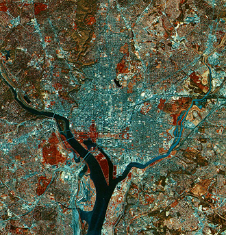
We now move to the eastern seaboard to focus on the southern part of the great metropolitan corridor that runs from Boston, through New York and Philadelphia, and past Baltimore and Washington, D.C. We show the latter two cities below in a subscene (about 113 km [70 mi] across) that was taken from the October 11, 1972 pass of Landsat-1 on a remarkable viewing day in which the air was crystal clear after a major storm passed.

The effects of that storm are evidenced by the light blue tones in the Potomac River, resulting from a heavy silt load dumped by runoff from the rainfall upstream. The increase in sediment does not affect the Chesapeake Bay to the east, of course, the inner city areas of Baltimore and Washington are by the blue tones that signify numerous large buildings and a limited number of trees. More than five million people live in this urban region but much of the population dwells in residential areas in which tree-dotted landscapes remain (recent surveys identified the Washington area, in particular, as the most heavily forested urban locale in the eastern U.S.). A large blotch of deep red (abundance of trees) in the northeast part of the Washington suburbs represents the largely undeveloped tract of land comprising the Beltsville Agricultural Experiment Station, which the U.S. Department of Agriculture operates. Interstate 95 between Washington and Baltimore - the heaviest traveled major road in the East - stands out in contrast to its vegetated edges. We can also see Highway 50 past Annapolis, the capital of Maryland,and, the high Bay Bridge over the Chesapeake narrows is just visible.
We use a SIR-C L-band radar image, which we obtained on April 18, 1994, from the Space Shuttle to look closer at the metropolitan area surrounding the U.S. capital.
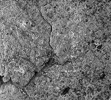
In this image, north is to the upper right. No distinct tonal patterns marking the more densely populated and built-up sections of the area are evident, but many of the major roads leading in and out appear as thin dark lines. Two dark patches coincide with the National Airport (just below the center) and Andrews Air Force base (lower right). Farmlands (diminishing as outlying areas develop) make up many of the other darker patterns. We find most of these farms to the east in the Coastal Plains.
The Coastal Plains' precise juncture (at the Fall Line) with the hilly Piedmont (see map on page 6-1 and following text) to the west is obscure but the rolling terrain on the left side of the image infers where the Piedmont begins. A remarkable feature of this image is the three light-toned lines forming part of a square. These lines coincide with the boundary between the District of Columbia and Maryland. Staff at the Jet Propulsion Laboratory (SIR-C's operators) interpreted this tonal phenomenon as expressing strong reflections from building corners that line avenues along the boundaries. But, this writer, who lived in the area for 21 years, is skeptical of the explanation, because there is no unusual concentration of large buildings lining the streets along the boundaries. Along the NE-SW edge many building are residences no different than other homes away from the boundary streets. The line next to the boundary running NW-SE (right side of square) that continues beyond the District is a power line.
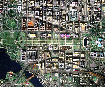
The next two SPOT images present much more detail. The false color version at the left (about 24 km [15 mi] on a side) is made by the HRV multispectral sensor that provides 20 meter resolution. On the right is a 10 meter panchromatic image that extends about 13 km (8 mi) on a side, showing the central city and its many federal buildings.
 |
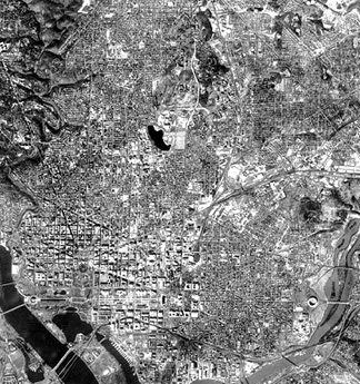 |
The HRV image nearly encompasses the Capitol Beltway which rings the Washington area but does not stand out here. Several vegetated areas are worth identifying: the wooded area known as Rock Creek Park; Roosevelt Island in the Potomac; the Arlington National Cemetery; and the National Arboretum. The circular Robert F. Kennedy (RFK) stadium is easily identified. (Check an atlas to locate these features.)
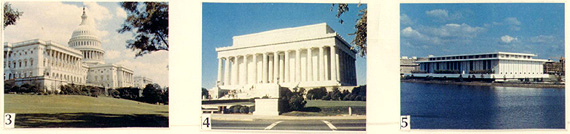
The centerpoint in this and the next two images is the Mall that runs from the Lincoln Memorial (4) eastward to the U.S. Capitol building (3). These two buildings (see below), along with the Kennedy Center for the Performing Arts (5), are examples of the graceful white marble edifices that house many of the government offices, monuments, and cultural centers, in what many believe is one of the most beautiful capital cities in the world.
This aerial oblique color photograph, which was taken from the Virginia side of the Potomac affords a "birds-eye" view of this central area.
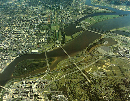
Viewers who have visited the capital city should recognize many of the landmarks. On the lower right is the Pentagon, and part of the National Cemetery is in the foreground. Beyond Roosevelt Island is the Kennedy Center. Nearby are the Lincoln Memorial and, on the Tidal Basin, the Jefferson Memorial. The White House is hidden by trees but the Ellipse (a near-circular drive and parkland) is just to its south. The Washington Monument is too thin to be seen clearly in this photo. But, many government office buildings lining the mall are evident.
The panchromatic SPOT image above shows the layout of buildings around the Mall and the downtown business area, as well as, homes (many are joined row houses) in the District. Consult a map to confirm the location of most of the well-known individual edifices. Use major streets such as Independence, Constitution, Pennsylvania, New York, and Massachusetts Avenues, and the Interstate 395 extension, so help locate sites.
Next is an identification challenge in this last image of Washington, D.C. We constructed it by merging a Landsat TM subscene rendered in the IHS (Intensity; Hue; Saturation) color system and a 2-meter (6.6 feet) resolution space photo made by cosmonauts using the Kosmos KVR-1000 camera onboard the Russian Mir space station.
Use a map to locate the following: Washington Monument; Jefferson Memorial; U.S. Capitol Building; Union Station; National Air and Space Museum; Hirschorn Gallery; National Gallery of Art; National Museum of Natural History; Smithsonian Administration Building; Federal Bureau of Investigation (FBI); The White House; U.S. Dept. of State; and the U.S. Dept. of the Treasury. However, don't look for the NASA building if you have an older map, because its headquarters has moved and most atlases don't show this new location.
4-10: There is something (a structure) in this image (related to the Kosmos part) that can give you the approximate time of day when Kosmos was passing over. Can you figure this out and estimate the hour. What important monument is out of the picture? ANSWER

Collaborators: Code 935 NASA GSFC, GST, USAF Academy
Contributor Information
Last Updated: September '99
Webmaster: Bill Dickinson Jr.
Site Curator: Nannette Fekete
Please direct any comments to rstweb@gst.com.