Paris, France; Florence, Italy
The next city we visit is another nation's capital and is quite familiar to those who've traveled Europe. Paris to many is the most beautiful urban area in the world. The city as depicted in a Spring 1976 Landsat MSS image looks like this:
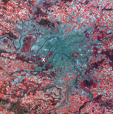
Especially prominent is the strongly meandering (bending) River Seine, which is joined by the Oise (west) and Marne (east) rivers of World War I fame. The large wooded area (red tones) within a river loop near the western limits of denser population is the Foret de St. Germaine. Central Paris, with its many famed monuments and buildings, lies just to the west of the juncture of the Marne with the Seine. Note that by April many of the outlying farms have actively growing crops (bright red tones).
Look now at a small part of this great metropolis as seen at 10 m resolution by the panchromatic sensor on SPOT.
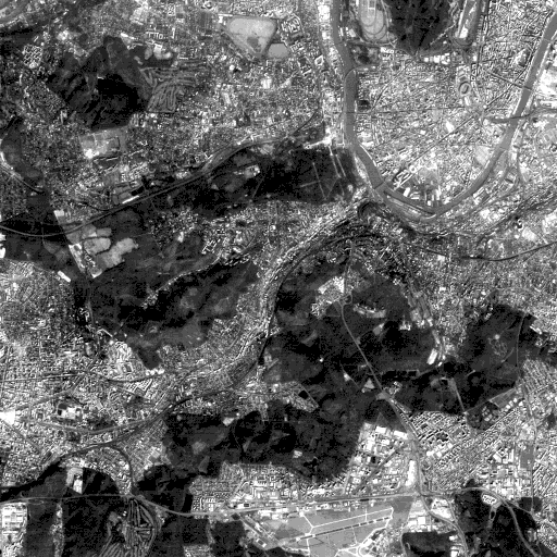
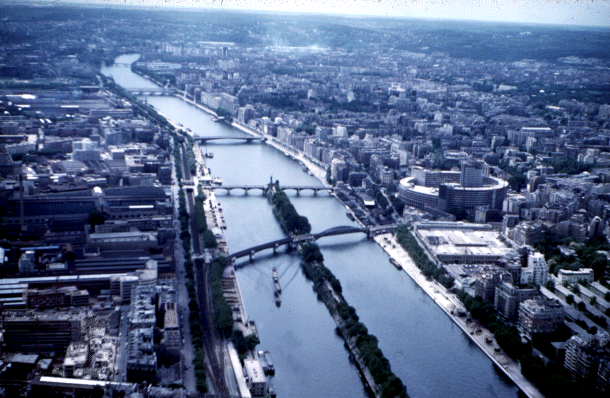
The upper right corner is about 1.2 km (0.75 mi) southwest of the Eiffel Tower, the symbol of this city. The panorama seen in the next picture is a view from this tower looking generally southwest towards the SPOT scene.
4-11:In the Landsat image above there is a white X. What does this refer to? ANSWER
4-12: Is any of the SPOT scene in the Eiffel photograph? ANSWER
The south end of a great meander loop of the Seine River that passes across this section of the city is prominent in the SPOT image. Within the loop is a community known as Boulogne Billancourt. The southern end of the Bois de Boulogne, the city's largest park, appears as a dark area at the top right. Note the nearby Longchamp and Aueteil race courses. The immediate district to the west is the Hauts de Seine (suggesting low hills). The feature that looks like a distorted pentagon is the Hippodrome de St. Cloud and to its left is the Fôret de la Malmaison, a forested tract just south of Rueil Malmaison. Next to it is an area resembling a golf course that actually is a U.S. Military Cemetery for the fallen of World War I.
The major road crossing this image center is a large expressway, the AutoRoute de l'Ouest (A13) to Rouen and then Le Havre on the English Channel. Adjacent is the Parc de St. Cloud, within the inner suburb by that name. The lower half of the image shows the highway A86 just above the Villacoublay airport. Route 10 winds northeast between the two irregular wooded areas bounded by Meudon on the east and the center of Versailles on the west. Route 118 passes northward through Velizy-Villacoubay, joining 10 near the Seine loop.
The last stop on this urban tour is another, but smaller (about a half million people) European city: This one is Firenza or Florence, nestled in the Tuscany hills several hundred kilometers north of Rome in Italy. Florence is known as the cradle of the Renaissance, the home of Michelangelo, and a treasure house of art and culture. Here it is in a radar color composite (LHH = red; LHV = green; CHV = blue. See Section 8 for an explanation of these bands and polarization modes) made by the SIR-C radar from the Space Shuttle on April 14, 1994:
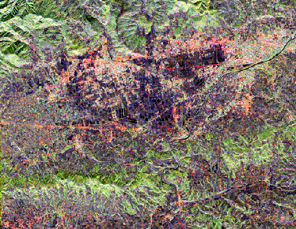
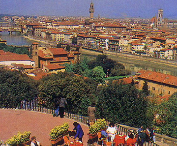
This view is at an odd orientation but north is towards the top. The River Arno passes through the image as a narrow, winding black band. That same river runs through the ground scene (below) taken from the Piazza Michelangelo on the south side of the city. The famed Ponte Vecchio (a 15th century covered bridge with shops and stalls still in business today) is one landmark. The tower in the town hall at the Piazza Vecchio lies near the photo center and part of the Duomo (cathedral) with Giotto's Tower is at the right edge.
In the radar composite (above), much of the city stands out in very dark gray to black tones, signifying low radar beam returns. The large, dark, partial "V" in the central city is the railroad station, which has a flat roof.
4-13: Speculate on a possible cause of the black tones. Check the ground photo again. ANSWER

Collaborators: Code 935 NASA GSFC, GST, USAF Academy
Contributor Information
Last Updated: September '99
Webmaster: Bill Dickinson Jr.
Site Curator: Nannette Fekete
Please direct any comments to rstweb@gst.com.