
MINERAL AND PETROLEUM EXPLORATION
We can synopsize the role of aerial photography and space imagery in searching for natural mineral, metal, and hydrocarbon resources in this diagram of an exploration model.
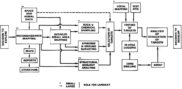
5-1: Before reading the next paragraph, try to deduce from the above diagram what is the single most critical step in determining whether the explorer has found, and proved, a mineral or petroleum deposit worthy of commercial development. ANSWER
Starting with the first stage (reconnaissance mapping of a broad region), the flow of activities leads us to select specific targets that reduce the total area to a few locations that we can effectively and economically examine in detail. Landsat, SPOT, and other space systems provide the regional inputs to visual databases that we must correlate with existing information from maps and publications. Computer image processing converts raw data into specialized thematic maps that emphasize certain characteristics of surface materials (telltale guides) and structures. We know from experience that these characteristics associate with concentrations of ore deposits and hydrocarbons . Once we designate candidate target areas , we begin more precise mapping, using imagery as a base but support it with ground checks and even detailed (local) mapping to pinpoint final targets. These targets can also be examined by appropriate subsurface geophysical methods, such as seismic refraction and gravity surveys. These methods may be applied early as a means of focusing on these ultimate targets. While information to this point may strongly indicate the presence of economically-viable deposits, the decisive test is nearly always to drill into the promising site(s). By drilling, we recover samples to evaluate the economic worth or, in the case of oil/gas, we encounter commercially-viable hydrocarbons.
Space-acquired data (principally images) supercede previous approaches, which relied on extensive ground and aerial surveys, simply by showing regional tracts of land. A full Landsat scene covers more than 34,000 square kilometers (13,000 square miles). The images can be examined as units by photointerpreters and by computer-aided image analysts, including the approach known as Geographic Information Systems (GIS) described in Section 15. After appropriate processing, these full scenes often reveal much smaller locales that display guides to mineralization or oil/gas deposits. This process potentially can save major exploration costs, because large unsuitable areas can be eliminated and field efforts confined to favorable areas. We illustrate this concept by demonstrating Landsat's capability to bring out surface signs of mineralization and then by evaluating a case study, which considers surface alteration and structural control that may point to underlying oil and gas traps.
Prospectors and miners for centuries, and exploration geologists for the last one hundred years or so, have sought certain telltale signs of valuable mineralization, especially gold, silver, copper, nickel and other metals. These metals often appear as abnormalities or anomalies at the Earth's surface. Most widespread among these guides is "gossan", a miner's term for rust. It is, in fact, a mix of several forms of hydrated iron oxides, including the mineraloid group limonite (FeO(OH) nH2O), that develop most commonly when iron-bearing minerals react with water and other chemicals during the natural weathering or alteration processes. The brownish to yellow-brown soil color and yellows and oranges of many sandstones (especially in the U.S. West) owe those distinctive tints to these secondary iron compounds. The reds in rocks usually result from the presence of hematite, a non-hydrated iron oxide (Fe2O3). The chief reason that gossan forms in areas where useful metals are concentrated is that pyrite, (FeS2), a common mineral also known as "fools gold" because of its brassy-yellow metallic color, is deposited with these other substances. Pyrite and other substances come from hydrothermal (hot water) and other kinds of solutions that usually come from deep, hot magmas to migrate upward into the Earth’s crust until they encounter conditions favoring precipitation as ore minerals. The most common ores of silver, copper, lead, zinc, nickel and cobalt are compounds of these metals with sulphur (as sulphides). While several of these also have discrete alteration products, the most conspicuous (whether seen from a pack mule or in a color aerial photo) is normally gossan and related iron products, that derive from the chemical breakdown of pyrite. Secondary minerals (including sulphates, carbonates, and clay minerals) that also may form by alteration, afford additional clues to the possible location of prized metals. Of course, the presence of gossan does not automatically guarantee the presence of economically extractable metals, because iron sulphides (usually worthless) may be the only or dominant mineralization.
The most common ores of silver, copper, lead, zinc, nickel and cobalt are compounds of these metals with sulphur (as sulphides). While several of these also have discrete alteration products, the most conspicuous (whether seen from a pack mule or in a color aerial photo) is normally gossan and related iron products, that derived from the chemical breakdown of pyrite. Secondary minerals (including sulphates, carbonates, and clay minerals) that also may form by alteration afford additional clues to the possible location of prized metals. Of course, the presence of gossan does not automatically guarantee the presence of economically extractable metals, because iron sulphides (usually worthless) may be the only or dominant mineralization.
5-2: Would you expect there to be some kind(s) of surface manifestations of petroleum reservoirs; if so, what? ANSWER
Geological Setting at White Mountain, Utah
We now investigate a superb illustration of this last situation. Here is a Landsat Thematic Mapper (TM) subscene of an area in southwestern Utah:

The subscene, about 35 km (22 mi) on a side, resides within Beaver Co., Utah. It is about 24 km (15 mi) west of the small town of Milford and 64 km (40 mi) north of Cedar City, gateway to Zion National Park to its south. The physiographic setting places this area well within the Basin and Range Province, which, geologically, is a series of generally north-south trending mountain blocks that are upfaulted between downdropped valleys or basins. The area lies within the High Desert country of the U.S. Southwest. On the left side of the image is a part of the Wah Wah Range, a typical block-fault mountain system. To the right are a group of isolated hills composed of eroded volcanic flows and small outliers, such as White Mountain (gray roundish landform near the image center), of Paleozoic sedimentary rocks. Lowlands within the scene extend into basins filled with eroded debris from the uplands, including alluvial wash (such as the bright-toned area in left center) that form sloping aprons. Distinguish this terrain from the clouds and their shadows. Just to the left of White Mountain is an elongated (east-west) area, about 8 km (5 mi) long, characterized in this false color version (bands 2-4) by blotchy orange-brown to tan tones. These colors are a classic expression of gossan staining associated with a mineralized zone.
5-3: Make sure you find this mineralized area with its distinctive staining; is there evidence for similar gossan elsewhere in the image? ANSWER

Collaborators: Code 935 NASA GSFC, GST, USAF Academy
Contributor Information
Last Updated: September '99
Webmaster: Bill Dickinson Jr.
Site Curator: Nannette Fekete
Please direct any comments to rstweb@gst.com.