
Central Pennsylvania Fold Belt
Our odyssey proceeds west into the heart of the Appalachian fold belt that dominates the land forms of central Pennsyvania.
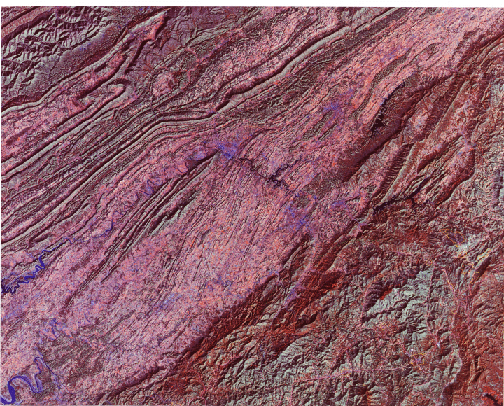
Most of the interior of this Landsat image depicts the Valley and Ridge province which runs from southernmost New York state to Alabama. Here, the sedimentary rocks that compiled thicknesses up to 15,250 m (50,000 ft) in parts of the geosynclinal deposition basin during the Paleozoic era, were strongly folded into anticlines (uparches) and synclines (downbends). These rocks were also shoved westward along thrust fault sheets. Erosion since the Appalachian Revolution has repeatedly sculpted ridges out of harder rocks (most commonly, sandstones) and valleys out of weaker rocks (such as shales). This erosion results in a zig-zag pattern developed from folds that also curve sharply as they pinch out, as seen in plan or horizontal perspective. The ridges, few of which are higher than 460 m (1,500 ft), remain heavily forested but the valleys are mostly cleared for agriculture. Toward the lower right corner, shales and limestones of early Paleozoic age underlay a broader lowlands, the Great Valley of Pennsylvania (the northern extension of the Shenandoah Valley of Virginia). The wide isolated ridge to the southeast is South Mountain/Catoctin Mountain, a complex of igneous-sedimentary-metamorphic rocks, which connects with similar rocks in the Blue Ridge in Virginia. The Appalachian Plateau occupies the western (left) part of the image and continues for several hundred kilometers into eastern Ohio. Its rocks are also Paleozoic sedimentary units that were not strongly folded (the compression effects die down in this region) and are still subhorizontal. However, the rock units were lifted en masse during the orogeny and, more recently, to elevations high enough to foster deep local stream cutting. The stream courses here are typical of the dendritic drainage pattern that develops on elevated terrain underlain by rocks of similar resistance to erosion.
6-6: The town of State College is the home of the Nittany Lions, the football team at Penn State University. It is situated in "Happy Valley" and is overlooked by Nittany Mountain; find it. Deep i the woods of South Mountain is a famed location where U.S. Presidents like to go; name it. ANSWER
The U.S. Appalachians extend into northern Georgia and Alabama, south of which they go underground, being buried by sediments comprising the Coastal Plains. Actually, the general orogenic belt that includes the Appalachian Mountains of eastern North America extends westward across the Mississippi River through the Ouachita Mountains of Arkansas/Oklahoma before dying out in Texas. Its northern end passes through Maine into Nova Scotia and Newfoundland and has been traced into mountain systems in the British Isles and Norway. The Atlas Mountains of northwestern Africa also link to the Appalachians. This once continuous belt split at the end of the Paleozoic Age, as the present continents broke apart and their tectonic plates then drifted in several directions.
We now take a momentary detour in our flight to look at parts of the central and southern Appalachians. The first scene shows much of the Appalachian Belt from Pennsylvania through North Carolina, as depicted in this Day-Vis (0.5 - 1.1 µm) image made by the Heat Capacity Mapping Radiometer on HCMM (see Section 9 for a description of this 1978 mission).
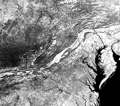
The swath width covered by the image is 715 km (444 miles); spatial resolution is 500 m (1,640 ft). To get your bearings at this scale, locate Washington, D.C. and Pittsburgh, PA on an atlas. This overview scene is shows the entire central part of the Appalachian Mountain system in a single view. The fold belt of the Valley and Ridge Province is distinctive. At the northern end, in Pennsylvania, the zig-zag pattern described above is determined by the closed or pitching anticlines and synclines. This type of folding largely disappears to the south, being replaced by subparallel ridges separated by valleys. Note the sharp bend or kink in the belt near Roanoke, VA. This feature is, in part, fault-controlled. We can see the Blue Ridge because it lies to the east of the Shenandoah Valley in Virginia that continues as the Great Valley through Pennsylvania (both in light tones). The Piedmont to the southeast is not particularly obvious in this image. Its terrain does not express well because of generally low relief. Its boundary with the Coastal Plains is the Fall Line, so-called because waterfalls form along some streams as they descend from harder Piedmont rocks to softer rocks toward the coast. This boundary is also diffuse, but generally its tone is darker than that of the Coastal Plains (more farming and less trees). The Cumberland Plateau, west of the belt, is much darker because of heavy forestation. As that province grades into the Allegheny Plateau, the dissected morphology remains, but forest cover diminishes.
6-7: Where is the Delmarva peninsula; locate the Shenandoah Valley of Civil War battle fame. Where is Pittsburgh. What state occupies the upper left 1/6th of the image? Name all the states that are entirely or partly present in the image. ANSWER
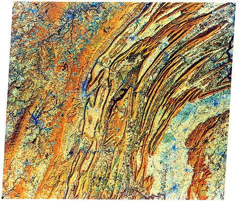
The second image is a Landsat subscene, covering about 100 km (62 miles) left-right, that contains parts of Tennessee, Virginia, and North Carolina. Kingsport, TN is the fuzzy blue patch in the center about 1/3 down. Douglas Lake on the French Broad River lies at the lower left corner.
A section of the Great Smoky Mountains, north of Ashville, occupies the lower right corner of the image. This is an assemblage of relatively homogeneous crystalline rocks that includes the Blue Ridge on their eastern side. Running diagonal through the image center is part of the Tennessee Valley, which is rolling hills underlain by more easily eroded limestones that tie into the Shenandoah Valley to the north. The Valley and Ridge is represented here by continuous folds of steeply dipping rocks that are also involved in the Pine Mountain thrust. The upper left is the beginning of the Cumberland Plateau, a southern extension of the Allegheny Plateau of Pennsylvania. Note the similarities and differences of this subscene and the earlier one. Here the South Mountain counterparts are much wider.

Collaborators: Code 935 NASA GSFC, GST, USAF Academy
Contributor Information
Last Updated: September '99
Webmaster: Bill Dickinson Jr.
Site Curator: Nannette Fekete
Please direct any comments to rstweb@gst.com.