
Chicago, Illinois
Proceeding westward, the plateau topography gradually gives way to gentle rolling hills and then (in central Ohio) to flat lands converted principally to farms and urban areas. Typical of the Interior Lowlands is the region around Chicago, Illinois, shown in this October scene.
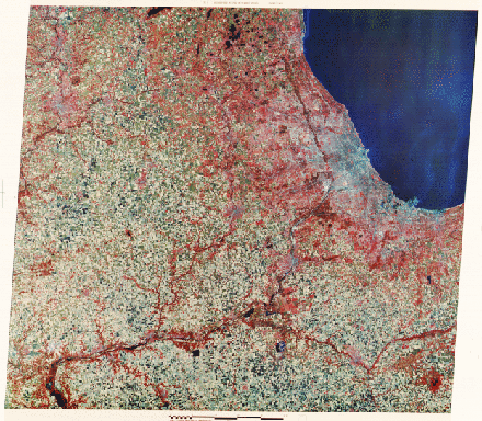
The governing rock type in this province is limestone, but nearly all of the surface here is controlled by glacial deposits. The rich soils from these materials promote farming, of which corn, soybeans, and oats make up the major crops. Most of fields in this scene are rectangular, and many now are fallow (tan-colored) after harvesting. Trees cluster along the banks of rivers such as the Illinois, Des Plaines, and Kankakee that stand out among the farms. The Chicago Loop and other dense buildings in central Chicago are visible in blue tones, while much of the surrounding metropolitan areas are expressed by the reds denoting trees in suburban settings. Chicago sits along the southwest tip of Lake Michigan, one of the five Great Lakes. All of them originated as basins cut by glacial scouring and, in places, from damming by moraines. Gary, Indiana is the blue area at the southern tip of the Lake.
6-8: What time of the year was this image probably made? Near Gary, IN, note the wispy clouds extending north-northeast into the Lake; what might they be? ANSWER

Collaborators: Code 935 NASA GSFC, GST, USAF Academy
Contributor Information
Last Updated: September '99
Webmaster: Bill Dickinson Jr.
Site Curator: Nannette Fekete
Please direct any comments to rstweb@gst.com.