
Denver, Colorado
In the next scene, we leave the Great Plains abruptly as the Front Range of the Rocky Mountains rises dramatically from the gently sloping high plains.
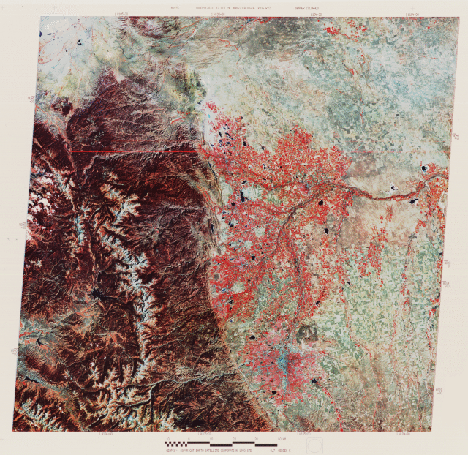
These mountains form the eastern edge of the North American Cordillera, which is made of groups of diverse, usually complexly-folded and faulted blocks of crust. These blocks are uplifted or thrust against other blocks separated by structural basins. They were deformed and emplaced during periods of major orogenies that were often disconnected in time and place. Rock units in the Rockies were finally compressed and shoved upwards about 65-70 million years ago. The present topography of these mountains is the result of strong erosion thereafter that has lowered their original heights to under 4,420 meters (14,500 ft). Alpine glaciation has steepened and widened already deep valleys, creating the rugged vistas that make this region especially popular for tourists and skiers. The barren (whitish) area along the crest of the Front Range coincides with the Continental Divide where it sits above the treeline. The slopes below are forested with Douglas fir, spruce, pine, and aspen trees. Rocky Mountain National Park is in the left center of the image. The southern end of the Medicine Bow Range in Wyoming extends into the image at the top left.
Denver, CO, appears at the edge of the plains in the lower center. To the right of the bluish downtown is a large square which is the Rocky Mountain Arsenal, once used for storage of military weapons. To Denver’s west, against the mountains, are thin elongated strips with yellowish and brownish colors. These strips are "hogbacks," which were steeply dipping sedimentary rocks, inclined down to the east as the Front Range rocks were pushed upwards. Those hogbacks with yellow tones are actually reddish (the Red Rocks Park contains them) but have this color variant in the false-color mode. Red colors within Denver and around Boulder and Fort Collins signify trees and crops still bright in the near-IR in this October scene. Their distribution is affected by proximity to the Platte and other rivers. These rivers provide irrigation for the alfalfa, hay, oats, corn, beets, and barley grown in this part of the Plains. Uncultivated areas, such as the Pawnee Grasslands (brownish patch at the right center), contain buffalo and grama grasses.
A January 1973 winter view of Denver places the region in a rather different perspective.
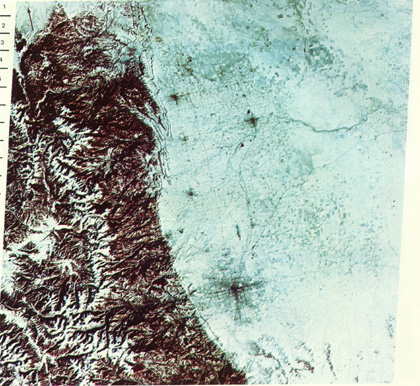
6-9: This winter scene brings out the infrastructure of much of Denver. Four large towns are now visible to the north; name them. Are they visible in the summer scene. Explain the brownish color associated with the Rockies. Is there snow above the treeline? What factor(S) help(s) to indicate drainage patterns. What happened to the lakes so visible in the summer image? ANSWER

Collaborators: Code 935 NASA GSFC, GST, USAF Academy
Contributor Information
Last Updated: September '99
Webmaster: Bill Dickinson Jr.
Site Curator: Nannette Fekete
Please direct any comments to rstweb@gst.com.