
The Nevada Basin and Range
The Colorado Plateau ends in western Utah. Almost the entire state of Nevada falls within the Basin and Range province. This image shows part of that province in
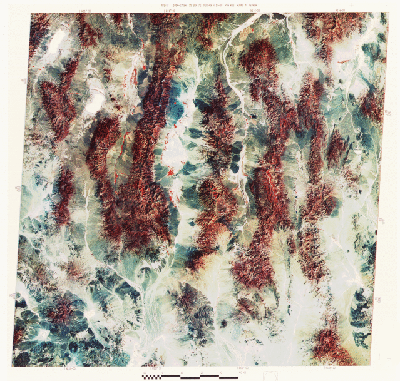
central Nevada. Major C.E. Dutton, an early explorer of the American West, described these mountains as they appeared on a map as resembling "an army of caterpillars crawling northward out of Mexico". Such characteristic topography results from a complex structural history dominated by block faulting (somewhat like the faulting we described in Kenya in Section 3). The region, as it underwent tensional stresses during uplift of the crust, responded by fracturing. The fractures trend mostly north-south, along which segments dropped down (faulted), leaving adjacent range blocks higher. The present elevations can be greater than 2,700 m (8,900 ft), producing relief of 900 to 1,520 m (3000 to 5000 ft) relative to the basins. The five major ranges in this scene are (left to right) the Shoshone, Toyabe, Toquima, Monitor, and Hot Creek Mountains; higher slopes are forested, as suggested by the reds in this September scene.
The intermontane basins between ranges are back-filled with great amounts of rock debris descending downslope, so that the valley floors move upwards as the ranges wear down. The central (lowest) surfaces of some of the basins contain playas (deposits of fine sediment left after intermittent lakes evaporate following the rainy season) that are light-toned in the image. Between playas and ranges, along the transitional zone known as a piedmont (literally, "foot of the mountain"), are deposits of coarser sediment (up to cobbles and boulders in size), mixed with clays that make up alluvial fans (dark gray in the image). Dry stream beds are also evident in the scene. Patches of red, especially in the central Big Smoky Valley, indicate local grasses and small farms that take advantage of moisture left from flow along intermittent streams (dry at this time). Tonapah and Warm Springs are the only towns located in this image. Note the dark basaltic lava flows just above the lower right corner.
By now, you have gained experience with picking out features in the landscape at the medium scales presented in Landsat imagery. Before finishing our trip, we challenge you to apply your experience by locating or identifying geographic and geologic landmarks in a space image somewhat to the south of our main flight line. This image is much smaller in scale, covering about 1,100 km (684 miles) on a side. Make this a game of finding the places listed below. Look over the black and white Day-Vis HCMM image that shows most of the southwestern U.S. (part of southern California and Nevada, most of Arizona, a bit of Utah, and small segments of the Mexican states of Baja California and Sonora), including some of the Basin and Range.
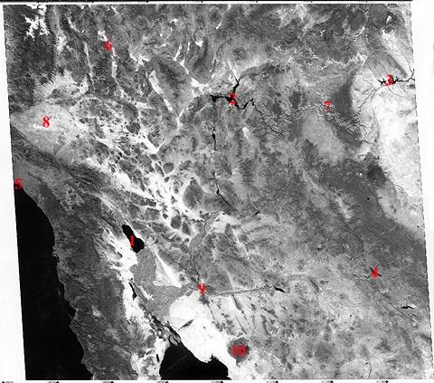
6-11: Use a U.S or World Atlas to aid in correlating landmarks in the scene with mapped features. To help you get oriented, the red numbers 1, 2, and 3 are the Salton Sea, Lake Mead, and Lake Powell, respectively. Pin these down on an atlas to give you a feel for the scale. Then, relying on the maps, identify what is at or around the numbers 4 through 10. (The answers are below). Finally, without the aid of number guides, try to find the Gulf of California, San Diego, the Imperial Valley, the Sierra Nevada range, Las Vegas, Phoenix, and Tucson. Also, what is the name of the great geologic fault that marks (as a straight tonal boundary) the southern edge of the Mojave Valley? ANSWER

Collaborators: Code 935 NASA GSFC, GST, USAF Academy
Contributor Information
Last Updated: September '99
Webmaster: Bill Dickinson Jr.
Site Curator: Nannette Fekete
Please direct any comments to rstweb@gst.com.