
The San Francisco Bay Area, California
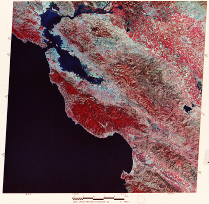
Our imaginary flight finally nears the Pacific Coastal and Interior Mountains. We proceed across the Sierra Nevadas, the large, strongly glaciated tilt block of crust composed mostly of igneous and metamorphic rocks. This mountain range rises precipitously to 4,421 m (14,494 ft) at Mt Whitney on its east side along great faults. We then pass over rolling ground in its Foothills across the Central Valley into the Coast Ranges around the San Francisco Bay area, shown in this October image
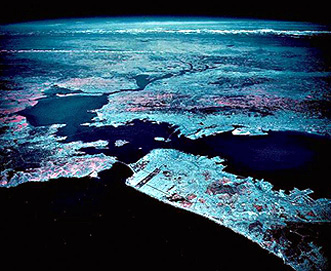
Most of the landmarks we describe next, we can see in this high-altitude aerial oblique image taken by a camera onboard a NASA U-2 aircraft. The view from this perspective looks east-northeast from a point over the Pacific Ocean. In the distance are the snow-capped Sierra Nevadas and the Sacramento Valley. Try to match specific features in this IR photo (which, incidentally, is blue-dominated because the sky blue effect was not compensated by a haze filter) with their counterparts in the Landsat image.
The Central Valley, known in its northern half as the Sacramento Valley (the southern half is the San Joaquin Valley), is one of the great agricultural regions of the world. The numerous farms visible in the above imagery attest to this dominant land use. Cash crops include beans, cotton, rice, barley, and sugar beets. Stockton and Modesto are the two large valley towns.
The Coast Ranges are the most recent products of still active orogeny that results from the collision of the Pacific and North American lithospheric plates. The mountains consist of granular (clastic) sediments in places metamorphosed by high temperatures and pressures or intruded by igneous magmas. Their rocks have been severely deformed, but the ranges generally rise only a few thousand feet above the Pacific sea level. Passing near the coast but inland is the great wrench (horizontal movement) fracture known as the San Andreas Fault (look for the abrupt termination of red [from California oaks, redwoods, and other vegetation] in the mountains south of San Franciso), which is the plane dividing the north-moving Pacific side of the fault from the more static North American side.
Two coastal bays stand out in this image: Monterey Bay near the bottom (noted for its rich aquatic and bird life) and San Francisco Bay, which to its north becomes San Pablo Bay, along which San Francisco (west), Oakland (east), San Jose (south) and many other Bay Area towns are situated. The fault-bounded hills to the east are part of the Diablo Range, which becomes progressively less vegetated towards the Great Valley (at this time of year it is covered with the same brown, dried grasses we examined in the Morro Bay subscene).
Most of San Francisco appears in grayish-blue tones that indicate a sparsity of trees in the city (rather surprising to any resident or visitor who is struck by its great beauty). The exceptions are the lush vegetation (many eucalyptus trees) in Golden Gate Park (long rectangle) and the Presidio (a now deactivated military facility). Your monitor resolution may allow you also to pick out a tine (blue) line of ships (mothballed Liberty Ships and others from World War II) right of the narrow Carquinez Straits off the east end of San Pablo Bay. In the southern part of the Bay are large patches with lighter blue or green tints. These are salt evaporating basins. The greenish ones are actually basins with red sediments (bright tones in Thematic Mapper band 3 that thus pass green light in a transparency).
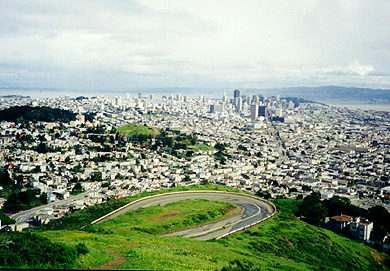
Many, including this writer, consider San Francisco the most beautiful city in the U.S. Here is a photo taken in 1994, by the writer that shows the central city from the tourist vista called Twin Peaks.
Lets take a closer look by enlarging the Bay Area portion of the image.
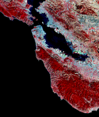
6-12: In the above subscene, find Berkeley, Oakland,Hayward; San Jose; the San Francisco Airport, Palo Alto, and Mount Diablo (near to which the writer lived for 2 glorious years). ANSWER
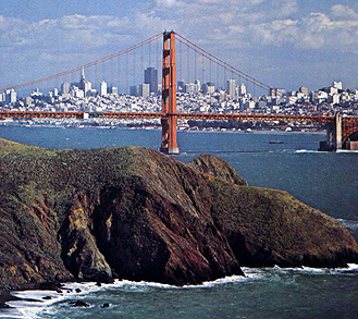
Carrying this enlargement even further to highlight the most famous bridge leading into the Peninsula, the Golden Gate Bridge. The view of "the City" through the bridge (image on the right) is from the vantage of a small park on the Marin County side (at X). The Presidio and Golden Gate Park are also obvious.
 |
 |
With this scene, we end our transcontinental sojourn. If you have crossed the states before, you can use this tour as a reminder of what you saw. If such a trip is in your future, this tour is a splendid preview of what you could look for. Bon voyage!
But wait! You should really be aiming to become a world traveler. Would be nice to have a world atlas composed of Landsat images (except, since up to 11000 are needed to cover all land areas, such an atlas would have more pages the a multi-book encyclopedia; we recommend using only images for areas where you expect to spend a lot of time). To affirm that you have now the skills needed to "read" a Landsat image, we are going to give you another (littler) test. On the next page are 8 full Landsat scenes, taken from any of the other continents besides North America. They are labeled from A to H. Using any means at your disposal (but a world atlas is best) try to locate each scene. To help you in this, we will put a few key word hints beneath each image. So, to proceed with the game, press "next".

Collaborators: Code 935 NASA GSFC, GST, USAF Academy
Contributor Information
Last Updated: September '99
Webmaster: Bill Dickinson Jr.
Site Curator: Nannette Fekete
Please direct any comments to rstweb@gst.com.